- National Register of Historic Places listings in Vermillion County, Indiana
-
 Location of Vermillion County in Indiana
This is a list of the National Register of Historic Places listings in Vermillion County, Indiana.
This is intended to be a complete list of the properties and districts on the National Register of Historic Places in Vermillion County, Indiana, United States. Latitude and longitude coordinates are provided for many National Register properties and districts; these locations may be seen together in a Google map.[1]
There are 8 properties and districts listed on the National Register in the county.
-
- This National Park Service list is complete through NPS recent listings posted November 10, 2011.[2]
Current listings
[3] Landmark name [4] Image Date listed Location City or town Summary 1 Clinton Downtown Historic District March 15, 2000 Roughly between S. Water and S. 3rd Sts., and Elm St. to the CSX railroad right-of-way
39°39′34″N 87°23′54″W / 39.659306°N 87.398278°WClinton 2 Eugene Covered Bridge 
June 10, 1994 Former County Road 00 over the Big Vermillion River
39°58′09″N 87°28′23″W / 39.969167°N 87.473056°WEugene 3 Hill Crest Community Center December 15, 1997 505 N. 8th St.
39°40′25″N 87°24′25″W / 39.673611°N 87.406944°WClinton 4 Newport Covered Bridge June 10, 1994 County Road 50N over the Little Vermillion River
39°53′28″N 87°26′00″W / 39.891111°N 87.433333°WNewport 5 Possom Bottom Covered Bridge June 10, 1994 Northern side of U.S. Route 36, 0.2 miles east of its junction with East Rd.
39°47′50″N 87°27′12″W / 39.797222°N 87.453333°WDana 6 Salem Methodist Episcopal Church February 22, 1979 North of Clinton on State Road 63
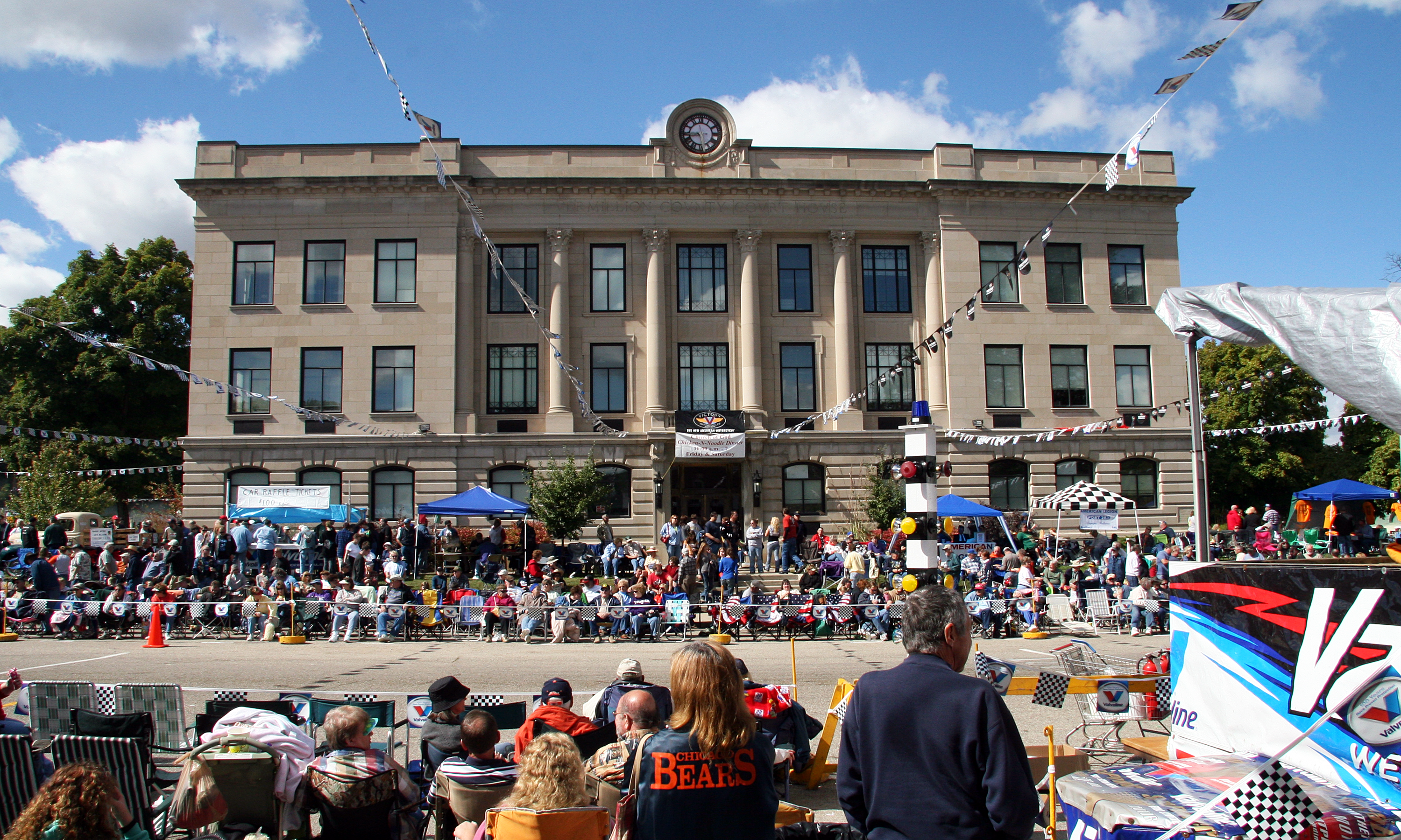
39°43′55″N 87°23′58″W / 39.731944°N 87.399444°WClinton 7 Vermillion County Courthouse 
December 19, 2007 255 S Main St.
39°53′05″N 87°24′34″W / 39.884722°N 87.409444°WNewport 8 Vermillion County Jail and Sheriff's Residence March 12, 1999 220 E. Market St.
39°51′27″N 87°24′22″W / 39.8575°N 87.406111°WNewport See also
- List of National Historic Landmarks in Indiana
- National Register of Historic Places listings in Indiana
References
- ^ The latitude and longitude information provided in this table was derived originally from the National Register Information System, which has been found to be fairly accurate for about 99% of listings. For about 1% of NRIS original coordinates, experience has shown that one or both coordinates are typos or otherwise extremely far off; some corrections may have been made. A more subtle problem causes many locations to be off by up to 150 yards, depending on location in the country: most NRIS coordinates were derived from tracing out latitude and longitudes off of USGS topographical quadrant maps created under North American Datum of 1927, which differs from the current, highly accurate GPS system used by Google maps. Chicago is about right, but NRIS longitudes in Washington are higher by about 4.5 seconds, and are lower by about 2.0 seconds in Maine. Latitudes differ by about 1.0 second in Florida. Some locations in this table may have been corrected to current GPS standards.
- ^ "National Register of Historic Places: Weekly List Actions". National Park Service, United States Department of the Interior. Retrieved on November 10, 2011.
- ^ Numbers represent an ordering by significant words. Various colorings, defined here, differentiate National Historic Landmark sites and National Register of Historic Places Districts from other NRHP buildings, structures, sites or objects.
- ^ "National Register Information System". National Register of Historic Places. National Park Service. . http://nrhp.focus.nps.gov/natreg/docs/All_Data.html.
U.S. National Register of Historic Places Topics Lists by states Alabama • Alaska • Arizona • Arkansas • California • Colorado • Connecticut • Delaware • Florida • Georgia • Hawaii • Idaho • Illinois • Indiana • Iowa • Kansas • Kentucky • Louisiana • Maine • Maryland • Massachusetts • Michigan • Minnesota • Mississippi • Missouri • Montana • Nebraska • Nevada • New Hampshire • New Jersey • New Mexico • New York • North Carolina • North Dakota • Ohio • Oklahoma • Oregon • Pennsylvania • Rhode Island • South Carolina • South Dakota • Tennessee • Texas • Utah • Vermont • Virginia • Washington • West Virginia • Wisconsin • WyomingLists by territories Lists by associated states Other  Category:National Register of Historic Places •
  Portal:National Register of Historic Places
Municipalities and communities of Vermillion County, Indiana County seat: Newport City 
Towns Cayuga | Dana | Fairview Park | Newport | Perrysville | Universal
Townships Clinton | Eugene | Helt | Highland | Vermillion
Unincorporated
communitiesAlta | Blanford | Bono | Centenary | Crompton Hill | Easytown | Eugene | Flat Iron | Gessie | Highland | Hillsdale | Jonestown | Klondyke | Needmore | Rhodes | Rileysburg | Saint Bernice | Sandytown | Summit Grove | Syndicate | Tree Spring | West Clinton | West Dana
Ghost towns Categories:- Vermillion County, Indiana
- National Register of Historic Places in Indiana by county
-


Wikimedia Foundation. 2010.