- Indiana State Road 63
Infobox road
state=IN
type=IN
route=63
alternate_name=George Rogers Clark Trail
maint=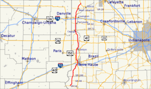
length_mi=96.17
length_round=2
length_ref= [http://www.in.gov/indot/3361.htm INDOT Roadway Referencing System] ]
established=1970s
direction_a=South
starting_terminus= in Merom
junction= in Terre Haute
in Terre Haute
in Terre Haute
in Terre Haute
near Montezuma
near Covington
near Covington
direction_b=North
ending_terminus= US 41 near Carbondale
counties=Sullivan, Vigo, Vermillion, Warren
cities=Terre Haute, Clinton
previous_type=IN
previous_route=62
next_type=IN
next_route=64State Road 63 in the U. S. state of
Indiana is a north-south route in the western portion of the state. It covers a distance of just over 96 miles. In the city of Terre Haute it becomes a four-lane divided highway and replacesU.S. Route 41 as the major route until it meets that highway again 63 miles to the north.Route description
State Road 63 starts as two-lane highway in the small town of Merom in Sullivan County at the terminus of State Road 58. From there it winds generally northward through the small towns of Graysville, Fairbanks, Prairie Creek and Prairieton.
The highway then passes through Terre Haute in Vigo County, where it is concurrent with US 41 and US 150 starting at Hulman Street; US 150 departs to the west after about a mile at Cherry Street. After another two miles, at Maple Avenue, State Road 63 separates from US 41, becomes a four-lane divided highway, and crosses to the west side of the
Wabash River ; US 41 continues on the east side of the river. From this point northward, State Road 63 remains within a few miles to the west of the river, and remains a four-lane divided highway; US 41 is primarily a two-lane highway from this point northward until it meets State Road 63 again.Continuing north, the highway passes through the city of Clinton in Vermillion County. North of Clinton, it does not pass through any other cities, but it does pass close to (in order from south to north) Montezuma, the
Newport Chemical Depot , Newport, Cayuga, Perrysville, Covington, and West Lebanon.At its northern terminus, it re-joins US 41 in northern Warren County, near the small town of Carbondale. At this point, US 41 once again becomes a four-lane divided highway, taking over from State Road 63.
History
The new State Road 63 was built in the early 1970s, bypassing West Lebanon and resulting in the 13-mile business route State Road 263 (which is a portion of the original route) through the town. The four-lane highway is often called "New 63" by local residents, and the business route is often called "Old 63".
Major intersections
INint
county=Sullivan
cspan=2
mile=0.00
road=
location=Merom
notes=Southern terminusINint
mile=10.62
road=
location=Sullivan CountyINint
county=Vigo
cspan=7
mile=16.25
road=
location=Vigo CountyINint
mile=28.70
road=
notes=Underpass
location=Terre Haute
lspan=6INint
mile=29.97
road=
notes=Concurrency begins at Hulman Street
type=concurINint
mile=31.15
road=INint
mile=31.15
road=
notes=Concurrency ends after 1.18 miles at Cherry Street
type=concurINint
mile=33.08
road=
notes=Concurrency ends after 3.11 miles at Maple Avenue
type=concurINint
mile=33.25
road=
notes=OverpassINint
county=Vermillion
cspan=6
mile=44.95
road=
location=ClintonINint
mile=54.92
road=
location=MontezumaINint
mile=63.17
road=
location=Vermillion CountyINint
mile=66.71
road=
location=Cayuga
notes=Ferry StreetINint
mile=73.66
road=
location=Vermillion County
lspan=2
notes=West of PerrysvilleINint
mile=78.31
road=
notes=OverpassINint
county=Warren
cspan=6
mile=79.84
road=
notes=Underpass
location=Warren County
lspan=4INint
mile=80.33
road=
notes=Southern terminus of SR 263 business routeINint
mile=89.87
road=
notes=West of West LebanonINint
mile=92.76
road=
notes=Northern terminus of SR 263 business routeINint
mile=95.62
location=Carbondale
lspan=2
road=
notes=UnderpassINint
mile=96.17
road=
notes=Northern terminusReferences
* [http://illi-indi.com/EndsPage.php?id=1063§ion=1 Indiana Highway Ends - SR 63]

Wikimedia Foundation. 2010.