- National Register of Historic Places listings in Rosebud County, Montana
-
 Location of Rosebud County in Montana
This is a list of the National Register of Historic Places listings in Rosebud County, Montana. It is intended to be a complete list of the properties and districts on the National Register of Historic Places in Rosebud County, Montana, United States. The locations of National Register properties and districts for which the latitude and longitude coordinates are included below, may be seen in a Google map.[1]
There are 20 properties and districts listed on the National Register in the county, including 1 National Historic Landmark.
-
- This National Park Service list is complete through NPS recent listings posted November 10, 2011.[2]
Listings county-wide
[3] Landmark name Image Date listed Location City or town Summary 1 Herman and Hannah Anderson House February 12, 1990 209 S. 7th Ave.
46°15′43″N 106°40′48″W / 46.261944°N 106.68°WForsyth 2 Blue Front Rooming House February 12, 1990 1187 Main St.
46°16′02″N 106°40′32″W / 46.267222°N 106.675556°WForsyth 3 Bones Brothers Ranch March 19, 2004 Along Hanging Woman Creek, 3 miles southeast of Birney and west of Custer National Forest
45°17′16″N 106°29′16″W / 45.287778°N 106.487778°WBirney 4 J.A. Bookman General Store September 2, 1994 Main St.
46°34′39″N 107°22′24″W / 46.5775°N 107.373333°WIngomar 5 Brotherhood of Locomotive Engineers Hall February 12, 1990 262 S. 7th Ave.
46°15′42″N 106°40′49″W / 46.261667°N 106.680278°WForsyth 6 Cold Springs Ranch House January 26, 1990 U.S. Route 12, W.
46°16′46″N 106°43′09″W / 46.279444°N 106.719167°WForsyth 7 First Presbyterian Church and Manse February 12, 1990 1160-1180 Cedar St.
46°16′03″N 106°40′32″W / 46.2675°N 106.675556°WForsyth 8 Forsyth Bridge February 12, 1990 3rd Ave. at the Yellowstone River
46°15′57″N 106°41′31″W / 46.265833°N 106.691944°WForsyth 9 Forsyth Main Street Historic District 
February 12, 1990 Roughly bounded by Cedar St., 11th Ave., Main St., and 8th St.
46°15′57″N 106°40′42″W / 46.265833°N 106.678333°WForsyth 10 Forsyth Residential Historic District February 12, 1990 Roughly bounded by Cedar St., 11th Ave., Willow St., 12th Ave., Oak St., and 14th Ave.
46°16′11″N 106°40′35″W / 46.269722°N 106.676389°WForsyth 11 Forsyth Water Pumping Station February 12, 1990 3rd Ave. at the Yellowstone River
46°15′58″N 106°41′23″W / 46.266111°N 106.689722°WForsyth 12 Howard School December 23, 2004 Old Montana Highway 10
46°16′12″N 106°53′58″W / 46.27°N 106.899444°WForsyth 13 Ingomar Public School September 2, 1994 2nd Ave.
46°34′38″N 107°22′17″W / 46.577222°N 107.371389°WIngomar 14 Claude O. Marcyes House February 12, 1990 390 S. 7th Ave.
46°15′38″N 106°40′45″W / 46.260556°N 106.679167°WForsyth 15 Rosebud County Courthouse 
April 17, 1986 1250 Main St.
46°16′04″N 106°40′28″W / 46.267778°N 106.674444°WForsyth 16 Rosebud County Deaconess Hospital November 16, 1979 N. 17th Ave
46°16′17″N 106°40′10″W / 46.271389°N 106.669444°WForsyth 17 St. Philip's Episcopal Church November 20, 2007 701 Main St.
46°16′33″N 106°26′24″W / 46.275833°N 106.44°WRosebud 18 Vananda Historic District 
April 19, 1990 U.S. Route 12, 17 miles west of Forsyth
46°23′29″N 107°00′07″W / 46.391389°N 107.001944°WForsyth 19 Wiley, Clark & Greening Bank September 2, 1994 Main St.
46°34′39″N 107°22′24″W / 46.5775°N 107.373333°WIngomar 20 Wolf Mountains Battlefield-Where Big Crow walked Back and Forth January 10, 2001 About four miles southwest of Birney, along the Tongue River
45°17′17.628″N 106°34′53.256″W / 45.28823°N 106.58146°W[4]Birney See also
- List of National Historic Landmarks in Montana
- National Register of Historic Places listings in Montana
References
- ^ The latitude and longitude information provided in this table was derived originally from the National Register Information System, which has been found to be fairly accurate for about 99% of listings. For about 1% of NRIS original coordinates, experience has shown that one or both coordinates are typos or otherwise extremely far off; some corrections may have been made. A more subtle problem causes many locations to be off by up to 150 yards, depending on location in the country: most NRIS coordinates were derived from tracing out latitude and longitudes off of USGS topographical quadrant maps created under the North American Datum of 1927, which differs from the current, highly accurate WGS84 GPS system used by Google maps. Chicago is about right, but NRIS longitudes in Washington are higher by about 4.5 seconds, and are lower by about 2.0 seconds in Maine. Latitudes differ by about 1.0 second in Florida. Some locations in this table may have been corrected to current GPS standards.
- ^ "National Register of Historic Places: Weekly List Actions". National Park Service, United States Department of the Interior. Retrieved on November 10, 2011.
- ^ Numbers represent an ordering by significant words. Various colorings, defined here, differentiate National Historic Landmark sites and National Register of Historic Places Districts from other NRHP buildings, structures, sites or objects.
- ^ Location and coordinates are derived from its National Historic Landmark nomination, pages 3 and 4; the NRIS lists it as "Address Restricted"
U.S. National Register of Historic Places Topics Lists by states Alabama • Alaska • Arizona • Arkansas • California • Colorado • Connecticut • Delaware • Florida • Georgia • Hawaii • Idaho • Illinois • Indiana • Iowa • Kansas • Kentucky • Louisiana • Maine • Maryland • Massachusetts • Michigan • Minnesota • Mississippi • Missouri • Montana • Nebraska • Nevada • New Hampshire • New Jersey • New Mexico • New York • North Carolina • North Dakota • Ohio • Oklahoma • Oregon • Pennsylvania • Rhode Island • South Carolina • South Dakota • Tennessee • Texas • Utah • Vermont • Virginia • Washington • West Virginia • Wisconsin • WyomingLists by territories Lists by associated states Other Municipalities and communities of Rosebud County, Montana Cities 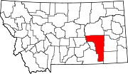
CDPs Unincorporated
communitiesIndian reservation Footnotes ‡This populated place also has portions in an adjacent county or counties
Categories:- National Register of Historic Places in Montana by county
- Rosebud County, Montana
-


Wikimedia Foundation. 2010.