- Northern Cheyenne Indian Reservation
-
 Northern Cheyenne Indian Nation flag
The Northern Cheyenne Indian Reservation, formerly named the Tongue River Indian Reservation, is an Indian reservation that is home to the Northern Cheyenne tribe of the Native Americans. It is located around the small towns of Lame Deer and Ashland, Montana, in parts of Rosebud and Big Horn counties. This land is located approximately 100 miles (160 km) east of the site of the 1876 Battle of Little Big Horn, or "Battle of Greasy Grass", as it is called by the Lakota. Small parcels of non-contiguous off-reservation trust lands are in Meade County, South Dakota, northeast of the city of Sturgis. The total land area is 706.976 square miles (1,831.059 km2), and a population of 4,789 was reported in the 2010 census.[1]
Approximately 91% of the population were Native Americans (full or part race), with 72.8% identifying as Cheyenne. Some Crow also live in this reservation. Slightly more than a quarter of the population 5 years or older spoke a language other than English.
The Northern Cheyenne were allies of the Lakota in the Black Hills War of 1876–77. Many of the people still care for this land. Numerous Cheyenne work as foresters, fire fighters and Emergency medical services employees, to help save the land they have left.
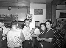 A bar in Birney, Montana near the Northern Cheyenne Indian Reservation in 1941 with a sign that reads "POSITIVELY NO BEER SOLD TO INDIANS".
A historical buffalo jump, burial sites of Indian chiefs, the site of Custer's last camp before the Battle of the Little Bighorn, the Cheyenne Indian Museum, Ten Bears Gallery, St. Labre Indian School, and the Ashland Powwow are sites of special interest in the Ashland area. Lame Deer is tribal headquarters and home of the Northern Cheyenne Powwow.
The Northern Cheyenne are close relatives of the Southern Cheyenne, an AmerInd nation located in Oklahoma. Following the Black Hills War and earlier conflicts in Colorado (see Sand Creek Massacre and Washita Massacre), the Northern Cheyenne were sent to Oklahoma to join their southern relatives. Unacclimated to the hot conditions of western Oklahoma (Indian Territory at the time), the northerners began dying like flies. In desperation, a small band left the reservation and headed north in 1878, an odyssey that later inspired Mari Sandoz's novel, Cheyenne Autumn.
The Northern Cheyenne briefly settled around Fort Keogh (Miles City, Montana). In the early 1880s, many families began to migrate south to the Tongue River watershed area and established homesteads in the northern edge of the Powder River Basin, which they considered their natural home. The United States established the Tongue River Indian Reservation, now named the Northern Cheyenne Indian Reservation, of 371,200 acres (1,502 km2) by executive order of President Chester A. Arthur on November 16, 1884.
The boundaries excluded Cheyenne who had homesteaded further east near the Tongue River. Those people were served by the St. Labre Catholic Mission. The western boundary is the Crow Indian Reservation. On March 19, 1900, President William McKinley extended the reservation to the west bank of the Tongue River, for a total of 444,157 acres (1,797.44 km2). Those Cheyenne who had homesteaded east of the Tongue River were relocated to reservation lands west of the river.[2] The Reservation's timbered ridges in southeastern Montana and northwestern South Dakota are also part of the Crow Reservation and Custer National Forest.
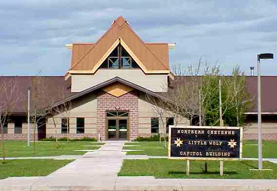
 Northern Cheyenne Reservation Headquarters 2003
Contents
Communities and neighborhoods
Lame Deer, Montana with about 4,000 residents, 92% of them American Indian, and is the capital of the Northern Cheyenne Tribe. Chief Dull Knife College is located there. To the west is Muddy, Montana with about 600 residents, 94% American Indian, and further west Busby, Montana with about 700 residents, 90% American Indian. Busby was the site of the Tongue River Boarding School opened in 1904, and later would become quite avid in Basketball. Also playing the Globe Trotters and beating them in a Basketball game also they would go to state and win from the 1950's. by the Indian Bureau (later called the Bureau of Indian Affairs (BIA).) The Busby White River Cheyenne Mennonite Church is located in Busby. Which is still standing and have regular Sunday church ceremonys.[3]
Ashland, Montana is to the east. In 1884 a Catholic boarding school, the St. Labre Indian School was established there.[4] The 460 residents of Ashland are about 75% American Indian. They would too start a basketball legend there and become very good in basketball. They would soon have Busby in their district and rivalry basketball games in the late 1940's and so on. Birney, Montana, population about 100, 86% Indian, is south of Lame Deer and Ashland. Part of Birney, "White Birney", lies south of the reservation.[5] Colstrip, Montana with about 2,300 residents, where some Cheyenne attend the Colstrip Public School, is about 20 miles north of the reservation.[6] About 240 American Indians live in Colstrip, making up 11% of the population. Colstrip is an industrial city devoted to coal mining and electrical generation. It was very tough to make it in Colstrip high school due to the case that most of all the students were white and Colstrip was around thirty miles away from the Northern Cheyenne reservation. But also they would soon realize that the Cheyenne people were very avid sports players and help lead them state in many sports they had to offer at Colstrip high school.
Education
Chief Dull Knife College, a Native American tribal community college and land grant institution, is located on the reservation in Lame Deer. The reservation is the recipient of a 2010 Promise Neighborhoods grant from the United States Department of Education, through the local Boys & Girls Clubs of America.[7]
References
- ^ "Census shows growth at 4 Montana reservations". helenair.com/Independent Record. 28 March 2011. http://helenair.com/news/article_98cba378-5967-11e0-a41b-001cc4c002e0.html. Retrieved 2 April 2011.
- ^ Page 30, We, the Northern Cheyenne People, accessed September 20, 2009
- ^ "Busby White River Cheyenne Mennonite Church", Global Anabaptist Mennonite Encyclopedia Online, accessed September 20, 2009
- ^ Page 91, We, the Northern Cheyenne People, accessed September 20, 2009
- ^ Page 48, We, the Northern Cheyenne People, accessed September 20, 2009
- ^ Page 91, We, the Northern Cheyenne People, accessed September 20, 2009
- ^ [1]
- We, the Northern Cheyenne People: our land, our history, our culture (2008), Ambler, Marjane; Little Bear, Richard E; Wilson, Dave; Tall Bull, Linwood; Hantz, Joan; Ward, Carol; Wertman, Bill; Chief Dull Knife College, Lame Deer, Montana
- Northern Cheyenne Reservation and Off-Reservation Trust Land, Montana/South Dakota United States Census Bureau
External links
- Northern Cheyenne Tribe Official site of the Tsétsêhéstâhese and Só'taeo'o people
Categories:- American Indian reservations in Montana
- American Indian reservations in South Dakota
- Geography of Big Horn County, Montana
- Buffalo jumps
- Cheyenne tribe
- Geography of Meade County, South Dakota
- Geography of Rosebud County, Montana
- 1884 establishments


Wikimedia Foundation. 2010.