- National Register of Historic Places listings in Montgomery County, Virginia
-
This list includes properties and districts listed on the National Register of Historic Places in Montgomery County, Virginia. Click the "Map of all coordinates" link to the right to view a Google map of all properties and districts with latitude and longitude coordinates in the table below.[1]
-
- This National Park Service list is complete through NPS recent listings posted November 10, 2011.[2]
[3] Landmark name [4] Image Date listed Location City or town Summary 1 Alleghany Springs Springhouse November 13, 1989 VA 637
37°07′43″N 80°15′49″W / 37.128611°N 80.263611°WAlleghany Springs 2 Amiss-Palmer House November 13, 1989 Mountain View Dr. and Penn St. off Eakin St.
37°13′36″N 80°24′27″W / 37.226667°N 80.4075°WBlacksburg 3 Barnett House November 13, 1989 US 460/11, 0.3 mi. S of jct. with VA 631
37°12′39″N 80°14′00″W / 37.210833°N 80.233333°WElliston 4 William Barnett House November 13, 1989 Off VA 637, 0.1 mi. N of VA 638
37°08′35″N 80°16′01″W / 37.143056°N 80.266944°WAlleghany Springs 5 Big Spring Baptist Church November 13, 1989 VA 631, 0.1 mi. E of US 460/11
37°12′55″N 80°13′30″W / 37.215278°N 80.225°WElliston 6 Bishop House November 13, 1989 0.1 mi. N of jct. of VA 693 and 613
37°02′16″N 80°33′19″W / 37.037778°N 80.555278°WGraysontown 7 Blacksburg Historic District January 31, 1991 Roughly, area N of jct. of Main and Jackson Sts. including sections out along Lee and Progress Sts.
37°13′54″N 80°24′46″W / 37.231667°N 80.412778°WBlacksburg 8 Blacksburg Motor Company, Inc. February 21, 2008 400 S. Main St.
37°13′43″N 80°24′42″W / 37.228611°N 80.411667°WBlacksburg 9 Blankenship Farm November 13, 1989 0.4 mi. S of jct. of VA 733 and 603
37°11′03″N 80°21′53″W / 37.184167°N 80.364722°WEllett 10 Bowyer-Trollinger Farm February 1, 1991 VA 600 N of jct. with VA 693
37°04′02″N 80°30′24″W / 37.067222°N 80.506667°WChildress 11 Pompey Callaway House November 13, 1989 VA 754, 0.2 mi. E of US 460
37°12′59″N 80°13′48″W / 37.216389°N 80.23°WElliston 12 Cambria Freight Station December 12, 1985 630 Depot St.
37°08′28″N 80°24′15″W / 37.141111°N 80.404167°WChristiansburg 13 Cambria Historic District January 10, 1991 500-600 blocks Depot St., 500-600 block Montgomery St., 900-1000 blocks Cambria St., and railroad depots
37°08′30″N 80°24′22″W / 37.141667°N 80.406111°WChristiansburg 14 James Charlton Farm November 13, 1989 VA 666, 1.3 mi. SW of VA 724
37°05′54″N 80°29′54″W / 37.098333°N 80.498333°WRadford 15 Christiansburg Presbyterian Church January 30, 1978 107 W. Main St.
37°07′42″N 80°24′41″W / 37.128333°N 80.411389°WChristiansburg 16 Crockett Springs Cottage November 13, 1989 1 mi. S of jct. of VA 637 and 609
37°05′37″N 80°15′13″W / 37.093611°N 80.253611°WPiedmont 17 Cromer House November 13, 1989 Off VA 787, 0.25 mi. E of VA 693
37°03′07″N 80°31′35″W / 37.051944°N 80.526389°WChildress 18 Currie House September 14, 1994 1105 Highland Cir.
37°13′25″N 80°23′39″W / 37.223611°N 80.394167°WBlacksburg 19 Earhart House November 13, 1989 VA 723, 0.3 mi. W of VA 603
37°11′44″N 80°21′59″W / 37.195556°N 80.366389°WEllett 20 George Earhart House November 13, 1989 VA 712, 0.5 mi. N of VA 723
37°12′25″N 80°21′44″W / 37.206944°N 80.362222°WNew Ellett 21 East Main Street Historic District January 10, 1991 E. Main St. from Roanoke and Pepper Sts. to the old high school and Park St. from E. Main to Lester St.
37°07′57″N 80°24′22″W / 37.1325°N 80.406111°WChristiansburg 22 Edgemont Church November 13, 1989 VA 666, 1 mi. E of VA 645
37°06′27″N 80°28′44″W / 37.1075°N 80.478889°WChristiansburg 23 Evans House No. 2 November 13, 1989 VA 685, 0.5 mi. W of VA 657
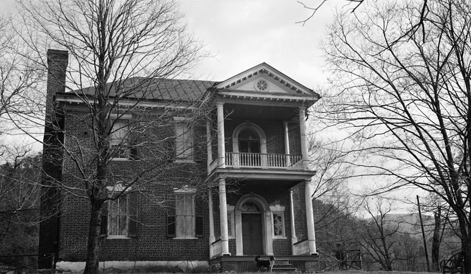
37°12′48″N 80°28′42″W / 37.213333°N 80.478333°WPrices Fork 24 Fotheringay 
November 12, 1969 S of jct. of Rtes. 11 and 631
37°10′43″N 80°14′36″W / 37.178611°N 80.243333°WElliston 25 Nealy Gordon Farm November 13, 1989 Off VA 637, 0.5 mi. S of jct. with VA 603
37°11′40″N 80°18′07″W / 37.194444°N 80.301944°WBrush Harbor 26 John Grayson House November 13, 1989 0.5 mi. NE of VA 613 bridge over Little River
37°02′52″N 80°33′28″W / 37.047778°N 80.557778°WGraysontown 27 Grayson-Gravely House November 13, 1989 VA 613 at Little River Bridge
37°02′36″N 80°33′46″W / 37.043333°N 80.562778°WGraysontown 28 Graysontown Methodist Church November 13, 1989 VA 613
37°02′13″N 80°33′40″W / 37.036944°N 80.561111°WGraysontown 29 Guerrant House November 13, 1989 VA 612 at VA 615
37°03′14″N 80°21′30″W / 37.053889°N 80.358333°WPilot 30 Thomas Hall House November 13, 1989 VA 667, 0.5 mi. SE of VA 600
37°04′40″N 80°30′43″W / 37.077778°N 80.511944°WChildress 31 Hornbarger Store November 13, 1989 VA 659, 0.1 mi. E of VA 719
37°09′50″N 80°29′10″W / 37.163889°N 80.486111°WVicker 32 Howard-Bell-Feather House November 13, 1989 VA 669 at Elliot Creek
37°04′01″N 80°24′32″W / 37.066944°N 80.408889°WRiner 33 Ingles Bottom Archeological Sites December 5, 1978 Address Restricted Radford 34 Keister House November 13, 1989 607 Giles Rd.
37°14′25″N 80°25′02″W / 37.240278°N 80.417222°WBlacksburg 35 Kentland Farm Historic and Archeological District July 3, 1991 At end of VA 623 along New R.
37°11′23″N 80°34′35″W / 37.189722°N 80.576389°WBlacksburg Boundary increase (listed September 6, 2006): W terminus Whitethorne Rd. 36 Michael Kinzer House November 13, 1989 VA 655, 1 mi. E of VA 624
37°14′01″N 80°27′32″W / 37.233611°N 80.458889°WBlacksburg 37 Lafayette Historic District January 10, 1991 Roughly, High St. from Main to Washington Sts., Main from High to Water Sts. and Church St. from Main to Washington
37°14′07″N 80°12′39″W / 37.235278°N 80.210833°WLafayette 38 Frank Lawrence House November 13, 1989 VA 612, 0.5 mi. E of VA 614
37°03′08″N 80°19′05″W / 37.052222°N 80.318056°WBasham 39 Linkous-Kipps House November 13, 1989 VA 657
37°12′27″N 80°27′32″W / 37.2075°N 80.458889°WMerrimac 40 Edgar A. Long Building March 5, 2001 140 Scatttergood Dr.
37°08′33″N 80°25′02″W / 37.1425°N 80.417222°WChristiansburg 41 Madison Farm Historic and Archeological District January 25, 1991 E and W sides of US 460 N of jct. with VA 633
37°11′00″N 80°14′12″W / 37.183333°N 80.236667°WElliston 42 Joseph McDonald Farm February 1, 1991 VA 657 NW of jct. with VA 685, at end of Spur Rd.
37°13′35″N 80°28′27″W / 37.226389°N 80.474167°WPrices Fork 43 Miller-Southside Residential Historic District January 11, 1991 Roughly bounded by Miller St., S. Main St., Airport Rd. and Preston Ave.
37°13′18″N 80°24′26″W / 37.221667°N 80.407222°WBlacksburg 44 Montgomery Primitive Baptist Church November 13, 1989 VA 624, SW of jct. with US 460/11
37°11′01″N 80°24′40″W / 37.183611°N 80.411111°WMerrimac 45 North Fork Valley Rural Historic District February 1, 1991 Along the North Fork of the Roanoke R. from the Roanoke Co. line S to Lusters Gate
37°15′58″N 80°18′56″W / 37.266111°N 80.315556°WBlacksburg 46 The Oaks July 15, 1994 311 E. Main St.
37°07′58″N 80°24′18″W / 37.132778°N 80.405°WChristiansburg 47 Odd Fellows Hall July 27, 2005 203 Gilbert St.
37°14′09″N 80°25′16″W / 37.235833°N 80.421111°WBlacksburg 48 Old Christiansburg Industrial Institute April 6, 1979 570 High St.
37°08′21″N 80°24′21″W / 37.139167°N 80.405833°WChristiansburg 49 Phillips-Ronald House November 13, 1989 Draper Rd. at Washington St.
37°13′37″N 80°24′49″W / 37.226944°N 80.413611°WBlacksburg 50 Phlegar Building November 13, 1989 2 S. Franklin St.
37°07′46″N 80°24′30″W / 37.129444°N 80.408333°WChristiansburg 51 Piedmont Camp Meeting Grounds Historic District January 10, 1991 Jct. of VA 637 and VA 602
37°06′14″N 80°13′03″W / 37.103889°N 80.2175°WPiedmont 52 Prices Fork Historic District January 10, 1991 Prices Fork Rd. from VA 737 roughly to VA 654
37°12′33″N 80°29′29″W / 37.209167°N 80.491389°WPrices Fork 53 Rife House November 13, 1989 VA 633 at US 460/11
37°10′38″N 80°14′13″W / 37.177222°N 80.236944°WShawsville 54 Riner Historic District January 10, 1991 Roughly, E and S of jct. of Main St. and Franklin Sts.
37°03′57″N 80°26′23″W / 37.065833°N 80.439722°WRiner 55 Shawsville Historic District January 10, 1991 Main St. E and W of jct. with VA 637
37°10′08″N 80°15′17″W / 37.168889°N 80.254722°WShawsville 56 Smithfield 
November 12, 1969 W of Blacksburg
37°13′26″N 80°25′56″W / 37.223889°N 80.432222°WBlacksburg 57 Solitude May 5, 1989 Greenhouse Rd. on Virginia Polytechnic Institute campus
37°13′34″N 80°25′38″W / 37.226111°N 80.427222°WBlacksburg 58 South Franklin Street Historic District January 10, 1991 100-308 S. Franklin St.
37°07′39″N 80°24′23″W / 37.1275°N 80.406389°WChristiansburg 59 Surface House November 13, 1989 High St., E of Depot St.
37°08′20″N 80°24′30″W / 37.138889°N 80.408333°WChristiansburg 60 Trinity United Methodist Church November 13, 1989 VA 723, 0.1 mi. S of VA 603
37°11′19″N 80°22′08″W / 37.188611°N 80.368889°WEllett 61 US Post Office-Christiansburg February 1, 1991 NW corner of public square
37°07′49″N 80°24′33″W / 37.130278°N 80.409167°WChristiansburg 62 Virginian Railway Underpass November 13, 1989 Jct. of Norfolk Southern Railway tracks and VA 723, S of New Ellett
37°11′58″N 80°21′51″W / 37.199444°N 80.364167°WNew Ellett 63 Adam Wall House November 13, 1989 VA 657, 0.5 mi. S of VA 685
37°12′28″N 80°28′04″W / 37.207778°N 80.467778°WPrices Fork 64 Walnut Grove Farm January 17, 1991 VA 609, 0.2 mi. SE of US 460/11
37°10′03″N 80°14′14″W / 37.1675°N 80.237222°WShawsville 65 Walnut Spring November 13, 1989 VA 655, 0.5 mi. E of jct. with VA 654
37°13′41″N 80°29′23″W / 37.228056°N 80.489722°WKanodes Mill 66 Whitethorn November 13, 1989 VA 685, 1 mi. W of jct. with US 460
37°12′31″N 80°27′04″W / 37.208611°N 80.451111°WBlacksburg 67 Yellow Sulphur Springs September 20, 1979 N of Christiansburg on VA 643
37°10′38″N 80°23′50″W / 37.177222°N 80.397222°WChristiansburg See also
- National Register of Historic Places listings in Virginia
- National Register of Historic Places listings in Radford, Virginia
- List of National Historic Landmarks in Radford, Virginia
References
- ^ The latitude and longitude information provided in this table was derived originally from the National Register Information System, which has been found to be fairly accurate for about 99% of listings. For about 1% of NRIS original coordinates, experience has shown that one or both coordinates are typos or otherwise extremely far off; some corrections may have been made. A more subtle problem causes many locations to be off by up to 150 yards, depending on location in the country: most NRIS coordinates were derived from tracing out latitude and longitudes off of USGS topographical quadrant maps created under the North American Datum of 1927, which differs from the current, highly accurate WGS84 GPS system used by Google maps. Chicago is about right, but NRIS longitudes in Washington are higher by about 4.5 seconds, and are lower by about 2.0 seconds in Maine. Latitudes differ by about 1.0 second in Florida. Some locations in this table may have been corrected to current GPS standards.
- ^ "National Register of Historic Places: Weekly List Actions". National Park Service, United States Department of the Interior. Retrieved on November 10, 2011.
- ^ Numbers represent an ordering by significant words. Various colorings, defined here, differentiate National Historic Landmark sites and National Register of Historic Places Districts from other NRHP buildings, structures, sites or objects.
- ^ "National Register Information System". National Register of Historic Places. National Park Service. . http://nrhp.focus.nps.gov/natreg/docs/All_Data.html.
U.S. National Register of Historic Places Topics Lists by states Alabama • Alaska • Arizona • Arkansas • California • Colorado • Connecticut • Delaware • Florida • Georgia • Hawaii • Idaho • Illinois • Indiana • Iowa • Kansas • Kentucky • Louisiana • Maine • Maryland • Massachusetts • Michigan • Minnesota • Mississippi • Missouri • Montana • Nebraska • Nevada • New Hampshire • New Jersey • New Mexico • New York • North Carolina • North Dakota • Ohio • Oklahoma • Oregon • Pennsylvania • Rhode Island • South Carolina • South Dakota • Tennessee • Texas • Utah • Vermont • Virginia • Washington • West Virginia • Wisconsin • WyomingLists by territories Lists by associated states Other Municipalities and communities of Montgomery County, Virginia Towns 
CDPs Belview | Elliston | Lafayette | Merrimac | Plum Creek | Prices Fork | Riner | Shawsville
Unincorporated
communitiesBradshaw‡ | Cambria | Centerville | McDonalds Mill | Midway Heights | Rogers | Sugar Grove
Footnotes ‡This populated place also has portions in an adjacent county or counties
Categories:- Montgomery County, Virginia
- National Register of Historic Places in Virginia
- Virginia-related lists
-


Wikimedia Foundation. 2010.