- National Register of Historic Places listings in Charlotte County, Virginia
-
This list includes properties and districts listed on the National Register of Historic Places in Charlotte County, Virginia. Click the "Map of all coordinates" link to the right to view a Google map of all properties and districts with latitude and longitude coordinates in the table below.[1]
-
- This National Park Service list is complete through NPS recent listings posted November 10, 2011.[2]
[3] Landmark name [4] Image Date listed Location City or town Summary 1 Annefield (Saxe, Virginia) 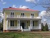
November 12, 2009 3200 Sunny Side Rd.
36°55′41″N 78°34′18″W / 36.928006°N 78.571639°WSaxe 2 Charlotte County Courthouse May 7, 1980 VA 40 and VA 47
37°03′20″N 78°38′16″W / 37.055556°N 78.637778°WCharlotte Court House 3 Charlotte Court House Historic District February 8, 1995 VA 40 between VA 645 and VA 47
37°03′26″N 78°38′39″W / 37.057222°N 78.644167°WCharlotte Court House 4 Clarkton Bridge January 26, 2007 VA 620 over the Staunton R
36°58′49″N 78°53′34″W / 36.980278°N 78.892778°WNathalie 5 Four Locust Farm December 3, 2009 U.S. Route 15
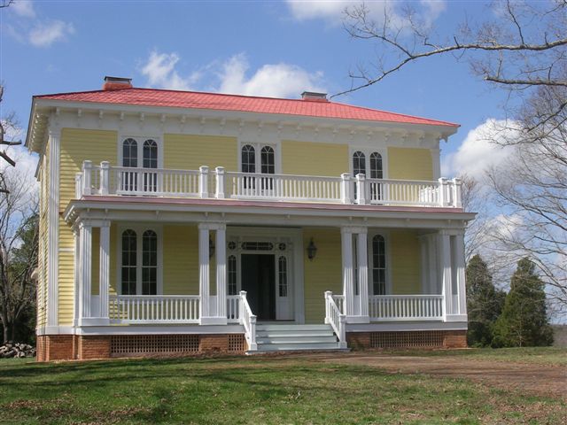
37°03′30″N 78°28′47″W / 37.058267°N 78.479611°WKeysville 6 Gravel Hill February 16, 2001 3990 Fearstown Rd.
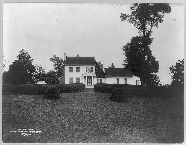
37°02′11″N 78°44′41″W / 37.036389°N 78.744722°WCharlotte Court House 7 Greenfield April 2, 1973 E of Charlotte Court House on VA 656
37°04′06″N 78°34′56″W / 37.068333°N 78.582222°WCharlotte Court House 8 Keysville Railroad Station November 12, 2008 Railroad Ave.
37°02′23″N 78°29′06″W / 37.039636°N 78.485033°WKeysville 9 Maple Roads September 14, 2002 1325 Richardson Rd.
37°03′48″N 78°31′19″W / 37.063333°N 78.521944°WKeysville 10 Mulberry Hill March 20, 1973 N of Randolph on VA 641
36°54′29″N 78°41′49″W / 36.908056°N 78.696944°WRandolph 11 Red Hill 
February 14, 1978 SE of Brookneal on SR 677
37°01′52″N 78°53′44″W / 37.031111°N 78.895556°WBrookneal 12 Roanoke Plantation April 11, 1973 W of Saxe off VA 746
36°54′45″N 78°42′50″W / 36.9125°N 78.713889°WSaxe 13 Salem School October 30, 1998 Jct. of Rtes. 608 and 632
36°46′10″N 78°38′14″W / 36.769444°N 78.637222°WRed Oak 14 Staunton Hill October 1, 1969 SW of jct. of Rtes. 619 and 693
37°00′27″N 78°51′59″W / 37.0075°N 78.866389°WBrookneal 15 Toombs Tobacco Farm January 28, 2000 1125 Tates Mill Rd.
36°47′04″N 78°35′36″W / 36.784444°N 78.593333°WRed Oak 16 Wade Archeological Site (44CH0062) October 23, 2003 1035 Fort Hill Trail
36°53′13″N 78°42′17″W / 36.886944°N 78.704722°WRandolph 17 Watkins House May 27, 2004 3115 Briery Rd.
37°04′27″N 78°30′24″W / 37.074167°N 78.506667°WKeysville 18 Westview February 4, 2000 1672 Terrell Rd.
37°01′37″N 78°51′53″W / 37.026944°N 78.864722°WBrookneal 19 Woodfork January 24, 2002 3704 Woodfork Rd.
37°06′05″N 78°39′56″W / 37.101389°N 78.665556°WCharlotte Court House See also
- National Register of Historic Places listings in Virginia
- List of National Historic Landmarks in Virginia
References
- ^ The latitude and longitude information provided in this table was derived originally from the National Register Information System, which has been found to be fairly accurate for about 99% of listings. For about 1% of NRIS original coordinates, experience has shown that one or both coordinates are typos or otherwise extremely far off; some corrections may have been made. A more subtle problem causes many locations to be off by up to 150 yards, depending on location in the country: most NRIS coordinates were derived from tracing out latitude and longitudes off of USGS topographical quadrant maps created under North American Datum of 1927, which differs from the current, highly accurate GPS system used by Google maps. Chicago is about right, but NRIS longitudes in Washington are higher by about 4.5 seconds, and are lower by about 2.0 seconds in Maine. Latitudes differ by about 1.0 second in Florida. Some locations in this table may have been corrected to current GPS standards.
- ^ "National Register of Historic Places: Weekly List Actions". National Park Service, United States Department of the Interior. Retrieved on November 10, 2011.
- ^ Numbers represent an ordering by significant words. Various colorings, defined here, differentiate National Historic Landmark sites and National Register of Historic Places Districts from other NRHP buildings, structures, sites or objects.
- ^ "National Register Information System". National Register of Historic Places. National Park Service. . http://nrhp.focus.nps.gov/natreg/docs/All_Data.html.
U.S. National Register of Historic Places Topics Lists by states Alabama • Alaska • Arizona • Arkansas • California • Colorado • Connecticut • Delaware • Florida • Georgia • Hawaii • Idaho • Illinois • Indiana • Iowa • Kansas • Kentucky • Louisiana • Maine • Maryland • Massachusetts • Michigan • Minnesota • Mississippi • Missouri • Montana • Nebraska • Nevada • New Hampshire • New Jersey • New Mexico • New York • North Carolina • North Dakota • Ohio • Oklahoma • Oregon • Pennsylvania • Rhode Island • South Carolina • South Dakota • Tennessee • Texas • Utah • Vermont • Virginia • Washington • West Virginia • Wisconsin • WyomingLists by territories Lists by associated states Other  Category:National Register of Historic Places •
  Portal:National Register of Historic Places
Municipalities and communities of Charlotte County, Virginia County seat: Charlotte Court House Towns 
Unincorporated
communitiesCategories:- Charlotte County, Virginia
- National Register of Historic Places in Virginia
- Virginia-related lists
-

Wikimedia Foundation. 2010.