- National Register of Historic Places listings in Adair County, Oklahoma
-
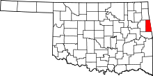 Location of Adair County in Oklahoma
This is a list of the National Register of Historic Places listings in Adair County, Oklahoma.
This is intended to be a complete list of the properties on the National Register of Historic Places in Adair County, Oklahoma, United States. The locations of National Register properties for which the latitude and longitude coordinates are included below, may be seen in a Google map.[1]
There are 5 properties listed on the National Register in the county.
-
- This National Park Service list is complete through NPS recent listings posted November 10, 2011.[2]
Current listings
[3] Landmark name [4] Image Date listed Location City or town Summary 1 Adair County Courthouse 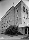
August 23, 1984 Division St.
35°48′51″N 94°37′43″W / 35.814167°N 94.628611°WStilwell art deco courthouse built in 1930 2 Buffington Hotel 
February 23, 1984 Main St.
35°59′36″N 94°34′05″W / 35.993333°N 94.568056°WWestville historic hotel built in 1910 3 Rev. Jesse Bushyhead Grave December 6, 2004 State Highway 59
36°02′08″N 94°34′58″W / 36.035556°N 94.582778°WWestville grave of Cherokee religious and political leader topped with 15-foot-tall (4.6 m) marble monument 4 Golda's Mill November 9, 1972 12 miles northwest of Stilwell
35°51′34″N 94°45′53″W / 35.859444°N 94.764722°WStilwell water mill built in 1882 and operated until destroyed by fire in 1983 5 Opera Block February 23, 1984 Main St.
35°59′35″N 94°34′05″W / 35.993056°N 94.568056°WWestville built in 1912 and demolished in 1998 See also
- List of National Historic Landmarks in Oklahoma
- National Register of Historic Places listings in Oklahoma
References
- ^ The latitude and longitude information provided in this table was derived originally from the National Register Information System, which has been found to be fairly accurate for about 99% of listings. For about 1% of NRIS original coordinates, experience has shown that one or both coordinates are typos or otherwise extremely far off; some corrections may have been made. A more subtle problem causes many locations to be off by up to 150 yards, depending on location in the country: most NRIS coordinates were derived from tracing out latitude and longitudes off of USGS topographical quadrant maps created under North American Datum of 1927, which differs from the current, highly accurate GPS system used by Google maps. Chicago is about right, but NRIS longitudes in Washington are higher by about 4.5 seconds, and are lower by about 2.0 seconds in Maine. Latitudes differ by about 1.0 second in Florida. Some locations in this table may have been corrected to current GPS standards.
- ^ "National Register of Historic Places: Weekly List Actions". National Park Service, United States Department of the Interior. Retrieved on November 10, 2011.
- ^ Numbers represent an ordering by significant words. Various colorings, defined here, differentiate National Historic Landmark sites and National Register of Historic Places Districts from other NRHP buildings, structures, sites or objects.
- ^ "National Register Information System". National Register of Historic Places. National Park Service. . http://nrhp.focus.nps.gov/natreg/docs/All_Data.html.
U.S. National Register of Historic Places Topics Lists by states Alabama • Alaska • Arizona • Arkansas • California • Colorado • Connecticut • Delaware • Florida • Georgia • Hawaii • Idaho • Illinois • Indiana • Iowa • Kansas • Kentucky • Louisiana • Maine • Maryland • Massachusetts • Michigan • Minnesota • Mississippi • Missouri • Montana • Nebraska • Nevada • New Hampshire • New Jersey • New Mexico • New York • North Carolina • North Dakota • Ohio • Oklahoma • Oregon • Pennsylvania • Rhode Island • South Carolina • South Dakota • Tennessee • Texas • Utah • Vermont • Virginia • Washington • West Virginia • Wisconsin • WyomingLists by territories Lists by associated states Other  Category:National Register of Historic Places •
  Portal:National Register of Historic Places
National Register of Historic Places in Adair County, Oklahoma Stilwell 
Westville See also: National Register of Historic Places listings in Adair County, Oklahoma and List of National Historic Landmarks in Oklahoma Categories:- Adair County, Oklahoma
- National Register of Historic Places in Oklahoma by county
-


Wikimedia Foundation. 2010.