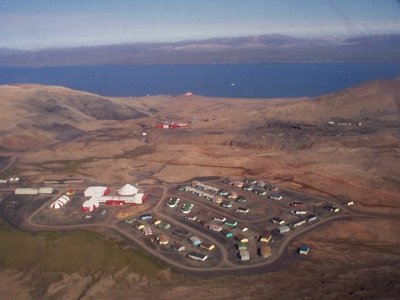
- Nanisivik
-
Nanisivik — Company town — Aerial view of Nanisivik
 Nanisivik
Coordinates: 73°02′05″N 84°32′13″W / 73.03472°N 84.53694°W Country  Canada
Territory  Nunavut
Region Qikiqtaaluk Highest elevation 341 m (1,119 ft) Lowest elevation 0 m (0 ft) Population (2006) - Total 0 Time zone EST (UTC-5) - Summer (DST) EDT (UTC-4) Postal Code X0A 0X0 Area code(s) 867 Telephone Exchange 436 GNBC Code OALHI NTS Map 048C01 Nanisivik (Inuktitut syllabics: ᓇᓂᓯᕕᒃ, translation for the place where people find things) was a company town which was built in 1975 to support the lead-zinc mining and mineral processing operations for the Nanisivik Mine, in production between 1976 and 2002. The townsite was located just inland from Strathcona Sound, about 20 km (12 mi) east of the community of Arctic Bay in the Canadian territory of Nunavut.
There is a port and dock about 3.7 km (2.3 mi) north of the former mine site which was used for shipping concentrate from the site, and receiving supplies (73°04′08″N 084°32′57″W / 73.06889°N 84.54917°W). It is currently used by the Canadian Coast Guard for training.[1]
Nanisivik Airport located 8 NM (15 km; 9.2 mi) south[2] was used as the main airport for Arctic Bay until 2010 when the lengthened Arctic Bay Airport took over. The airport is about 19 km (12 mi) directly southeast of Arctic Bay but the road between them is 32 km (20 mi).[3]
Contents
Mine closure
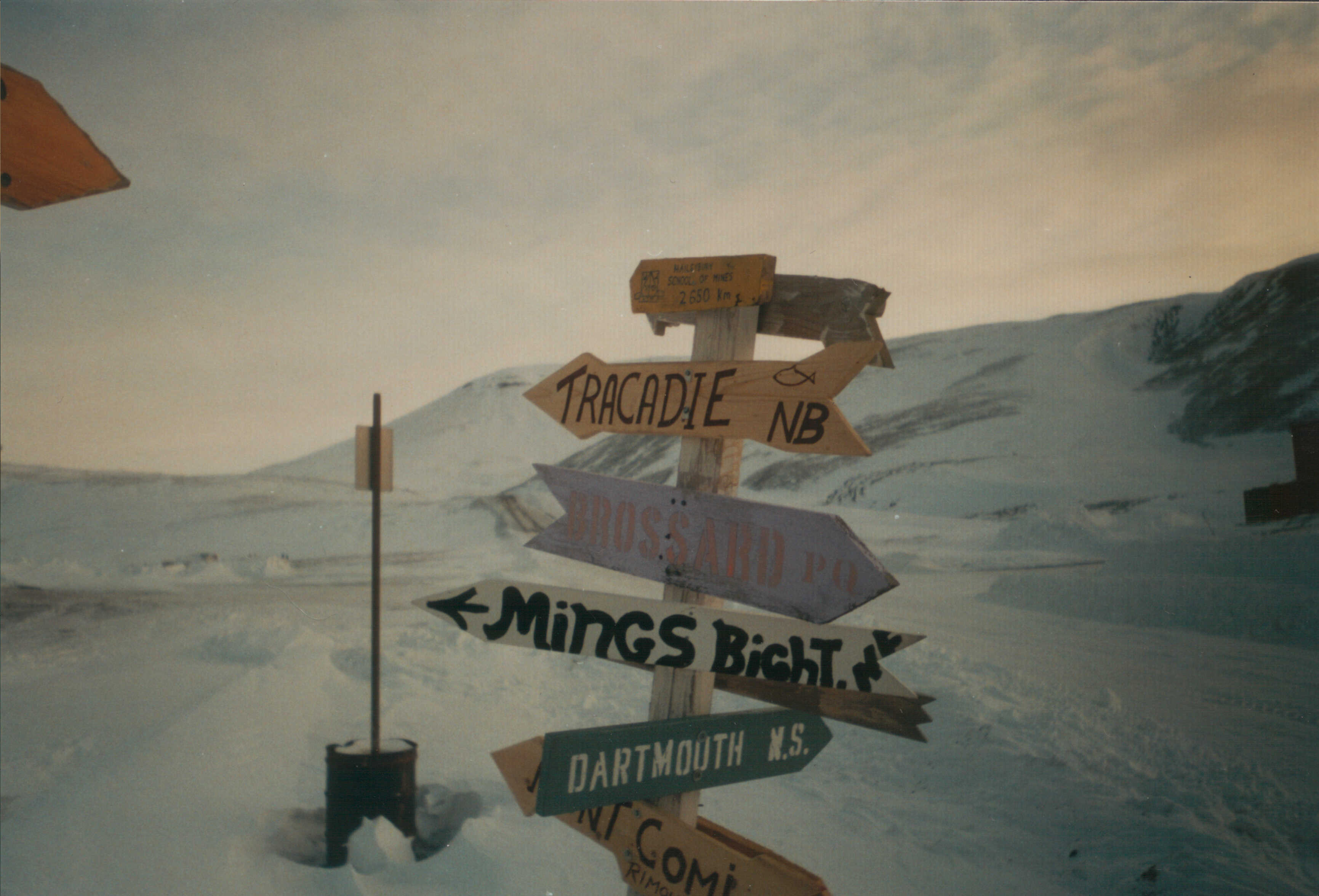
 One of three signposts in Nanisivik showing directions to various cities and towns
Since the closure of the mine in 2002, reclamation has been ongoing and the town is abandoned. Residents of Arctic Bay had hoped that the Government of Nunavut would be able to find a new use for the former townsite, potentially a trades training centre. They had also hoped to be able to move some of the buildings and equipment to their community.[4] Due to heavy lead-zinc contamination, this was not possible and the homes have been demolished.[5] Local telephone service was discontinued on February 19, 2007 on approval from CRTC.
As of the 2006 census the population was 0, a drop from the 2001 census with a population of 77.[6][7]
Main article: Nanisivik Naval FacilityOn August 8, 2007, CBC News reported that Canadian Forces documents showed plans to convert the site into a naval station. The plan, which would turn the former mine's existing port into a deepwater facility, would cost $60 million and it was expected that Prime Minister Stephen Harper would make an announcement during his stop in Resolute.[8]
On August 10, 2007, Prime Minister Stephen Harper announced construction of a new docking and refueling facility in Nanisivik for the Canadian Forces, in an effort to maintain a Canadian presence in Arctic waters during the navigable season (June–October). The choice for Nanisivik as a site was partially based on its location within the eastern entrance to the Northwest Passage, and the existence of a deep-water berthing facility at the site, as well as a "jet-capable" airstrip nearby.
Detailed planning for the project began in August 2007, with environmental studies and assessments being carried out in the summer of 2008. Construction at the site is expected to begin in the summer of 2010, with early operating capability available in 2012. The facility is planned to be fully operational by 2015.[9]
Once completed, the naval station will likely be home to the proposed Arctic Off-Shore Patrol Ships under the current Harper government plan.[10][11] These ships will have ice-breaking capability and help the current government's goal to enforce Canada's sovereignty over the region. These ships will likely allow the Victoria-class submarines to travel in the Arctic regions.
The facility was to have an initial operational capability in 2012, and be fully complete in 2015 but is behind schedule.[12][13]The facility was planned to be fully operational by 2015[14][15]
Climate
Climate data for Nanisivik Airport Month Jan Feb Mar Apr May Jun Jul Aug Sep Oct Nov Dec Year Humidex -3.0 -3.3 -7.1 -1.4 6.5 14.5 18.4 15.9 9.0 1.0 -6.3 -5.3 18.4 Record high °C (°F) −2
(28.4)2.0
(35.6)−5.5
(22.1)−0.5
(31.1)7.0
(44.6)18.5
(65.3)18.2
(64.8)15.0
(59.0)8.0
(46.4)0.5
(32.9)−6
(21.2)−4.4
(24.1)18.5
(65.3)Average high °C (°F) −26.1
(−15.0)−27.5
(−17.5)−24.8
(−12.6)−16.6
(2.1)−7.8
(18.0)1.9
(35.4)7.4
(45.3)3.7
(38.7)−3.7
(25.3)−12.5
(9.5)−19.9
(−3.8)−23.7
(−10.7)−12.47
(9.56)Daily mean °C (°F) −29.2
(−20.6)−30.3
(−22.5)−27.8
(−18.0)−20
(−4.0)−10.7
(12.7)−0.4
(31.3)4.9
(40.8)1.5
(34.7)−5.6
(21.9)−14.9
(5.2)−22.7
(−8.9)−26.6
(−15.9)−15.15
(4.73)Average low °C (°F) −32.1
(−25.8)−33.1
(−27.6)−30.8
(−23.4)−23.4
(−10.1)−13.5
(7.7)−2.8
(27.0)2.5
(36.5)−0.8
(30.6)−7.4
(18.7)−17.2
(1.0)−25.4
(−13.7)−29.4
(−20.9)−17.78
(−0.01)Record low °C (°F) −48.5
(−55.3)−53
(−63.4)−47.5
(−53.5)−42
(−43.6)−28.3
(−18.9)−14
(6.8)−6
(21.2)−10
(14.0)−19.5
(−3.1)−35
(−31.0)−39.4
(−38.9)−45.5
(−49.9)−53
(−63.4)Wind chill −62.9 −72.3 −67 −54.8 −39.4 −24.9 −12.8 −21 −30.3 −50 −53.5 −60.6 −72.3 Precipitation mm (inches) 7.6
(0.299)3.9
(0.154)6.6
(0.26)9.8
(0.386)17.2
(0.677)23.5
(0.925)35.3
(1.39)40.9
(1.61)43.5
(1.713)30.9
(1.217)16.0
(0.63)7.3
(0.287)242.5
(9.547)Rainfall mm (inches) 0.0
(0)0.0
(0)0.0
(0)0.0
(0)0.0
(0)7.0
(0.276)27.5
(1.083)22.5
(0.886)4.4
(0.173)0.0
(0)0.0
(0)0.0
(0)61.4
(2.417)Snowfall cm (inches) 4.4
(1.73)3.8
(1.5)6.4
(2.52)9.8
(3.86)16.9
(6.65)15.7
(6.18)7.6
(2.99)17.3
(6.81)36.9
(14.53)31.2
(12.28)15.8
(6.22)7.3
(2.87)173.1
(68.15)Avg. precipitation days 4.3 4.4 5.7 6.1 8.7 8.5 11.3 12.4 14.2 13.1 8.1 5.3 102.1 Avg. rainy days 0.0 0.0 0.0 0.0 0.0 2.2 9.2 7.8 1.7 0.05 0.0 0.0 20.95 Avg. snowy days 4.2 4.4 5.7 6.1 8.7 6.9 2.7 5.7 12.9 13.1 8.2 5.4 84 Source: 1971-2000 Environment Canada[16] References
- ^ "Arcticnet - Naval gazing: Looking for a High Arctic port". http://www.arcticnet-ulaval.ca/index.php?fa=News.showNews&home=4&menu=55&sub=1&id=244. Retrieved 2007-08-07.
- ^ Canada Flight Supplement. Effective 0901Z 20 October 2011 to 0901Z 15 December 2011
- ^ Arctic Bay and Nanisivik
- ^ "Arctic Bay impatient with slow Nanisivik transfer talks". http://www.nunatsiaq.com/archives/nunavut021101/news/nunavut/21101_07.html. Retrieved 2007-08-17. mirror
- ^ "CBC - Contamination concerns grow at Nanisivik". CBC News. 2004-06-04. http://www.cbc.ca/canada/north/story/2004/06/04/nun-nanisivikconcern04062004.html. Retrieved 2007-08-17. mirror
- ^ "Stats Canada - 2006 Community Profiles". http://www12.statcan.ca/english/census06/data/profiles/community/Details/Page.cfm?Lang=E&Geo1=CSD&Code1=6204019&Geo2=PR&Code2=62&Data=Count&SearchText=nanisivik&SearchType=Begins&SearchPR=01&B1=All&Custom=. Retrieved 2007-08-07. mirror
- ^ "Stats Canada 2001 Data". http://www12.statcan.ca/english/Profil01/CP01/Details/Page.cfm?Lang=E&Geo1=CSD&Code1=6204019&Geo2=PR&Code2=01&Data=Count&SearchText=nunavut&SearchType=Begins&SearchPR=01&B1=All. Retrieved 2007-08-07. mirror
- ^ > "Planned army base, port in North heat up Arctic quest". CBC News. 2007-08-08. http://www.cbc.ca/canada/north/story/2007/08/08/arctic-setup.html?ref=rss. Retrieved 2008-08-10. mirror
- ^ "Backgrounder - Expanding Canadian Forces Operations in the Arctic". http://www.pm.gc.ca/eng/media.asp?id=1785. Retrieved 2007-08-17. mirror
- ^ "Nanisivik Naval Facility: Project Summary". Department of National Defence. 2009-03-26. http://ftp.nirb.ca/SCREENINGS/ACTIVE%20SCREENINGS/09DN018-DND%20-%20Nanisivik%20Naval%20Facility/1-SCREENING/01-APPLICATION/090326-09DN018-Project%20Summary-IMAE.pdf. Retrieved 2009-10-23.[dead link]
- ^ "Nanisivik Naval Facility Project: Overview Presentation to Stakeholders – 27 October 08". Department of National Defence. 2008-10-27. http://ftp.nirb.ca/SCREENINGS/ACTIVE%20SCREENINGS/09DN018-DND%20-%20Nanisivik%20Naval%20Facility/1-SCREENING/01-APPLICATION/090326-09DN018-Project%20Overview%20Presentation-IMAE.pdf. Retrieved 2009-10-23.[dead link]
- ^ Al Blondin (2007-09-05). "Breaking the ice to Nanisivik". The Maple Leaf. http://www.forces.gc.ca/site/commun/ml-fe/vol_10/vol10_25/1025_full.pdf. Retrieved 2009-10-23.
- ^ Al Blondin (2007-09-05). "New deep water facility to support Arctic offshore patrol ships". The Maple Leaf. http://www.forces.gc.ca/site/commun/ml-fe/vol_10/vol10_25/1025_full.pdf. Retrieved 2009-10-23.
- ^ "Backgrounder - Expanding Canadian Forces Operations in the Arctic". http://www.pm.gc.ca/eng/media.asp?id=1785. Retrieved 2007-08-17. mirror
- ^ "PM's Arctic tour delayed following Resolute Bay crash". CBC News. 2011-08-22. http://www.cbc.ca/news/politics/story/2011/08/22/pol-harper-arctic.html. Retrieved 2011-08-23. ]
- ^ Environment Canada—Canadian Climate Normals 1971–2000. Retrieved 22 June 2011.
External links
- Government will continue seeking positive legacy from Nanisivik mine closure, minister says. Government of Nunavut. October 1, 2002. Last accessed September 12, 2006.
- Welcome to the Arctic Bay & Nanisivik, Nunavut Photo Album!. Photographs by Vincent K. Chan. Last accessed September 12, 2006.
- "Arctic Bay and Nanisivik 2007". 2007. http://www.cbec.ca/nu/eng/nunavut_community_business_inventory_2007-2008/Arctic.pdf. Retrieved 2009-10-23.
 Subdivisions of Nunavut
Regions Communities Arctic Bay · Arviat · Baker Lake · Bathurst Inlet · Cambridge Bay · Cape Dorset · Chesterfield Inlet · Clyde River · Coral Harbour · Gjoa Haven · Grise Fiord · Hall Beach · Igloolik · Iqaluit Apex · Kimmirut · Kugaaruk · Kugluktuk · Pangnirtung · Pond Inlet · Qikiqtarjuaq · Rankin Inlet · Repulse Bay · Resolute · Sanikiluaq · Taloyoak · Whale CoveWeather stations
and Canadian Forces basesMine sites Proposed Baffinland Iron MineUnder construction Defunct Bent Horn Mine · Cullaton Lake/Shear Lake Mine · Jericho Diamond Mine · Lupin Mine · Nanisivik Mine · Polaris mine · Rankin Inlet MineDEW line and NWS sites Bernard Harbour · Bray Island · Brevoort Island · Broughton Island · Byron Bay · Cambridge Bay · Cape Dyer · Cape Hooper · Cape Mcloughlin · Cape Mercy · Cape Peel West · Cape Young · Clifton Point · Clinton Point · Croker River · Dewar Lakes · Durban Island · Edinburgh Island · Ekalugad · Gjoa Haven · Gladman Point · Hall Beach · Harding River · Hat Island · Jenny Lind Island · Kangok Fjord · Keats Point · Keith Bay · Kivitoo · Lady Franklin Point · Lailor River · Loks Land · Longstaff Bluff · Mackar Inlet · Matheson Point · Nudluardjuk Lake · Pelly Bay · Resolution Island · Ross Point · Rowley Island · Scarpa Lake · Shepherd Bay · Simpson Lake · Sturt PointFormer Amadjuak · Brooman Point Village · Craig Harbour · Dundas Harbour · Iglunga · Killiniq · Native Point · Nuwata · Padlei · Port Leopold · TavaniHudson's Bay Company
trading postsAmadjuak · Apex · Arctic Bay · Baker Lake · Bathurst Inlet · Bay Chimo · Belcher Islands · Blacklead Island · Cambridge Bay · Cape Dorset · Charlton Island Depot · Chesterfield Inlet · Clyde River · Coats Island · Dundas Harbour · Eskimo Point · Fort Hearne · Fort Ross · Frobisher Bay · Gjoa Haven · Igloolik · Kent Peninsula · King William Island · Kugaryuak · Lake Harbour · Mansel Island · Nueltin House · Padley · Pangnirtung · Pangnirtung Fox Farm · Perry River · Ponds Inlet · Port Leopold · Port Burwell · Repulse Bay · Southampton Island · Tavane · Tree River · Wager InletCoordinates: 73°02′05″N 084°32′13″W / 73.03472°N 84.53694°W
Categories:- Baffin Island
- Company towns in Canada
- Mining communities in Nunavut
- Ports and harbours of Nunavut
- Former populated places in Arctic Canada
- Former populated places in the Qikiqtaaluk Region

Wikimedia Foundation. 2010.