- Caeroesi
-
The Caeroesi (spelling variants include Caeraesi, Ceroesi, Cerosi) were a tribe living in Belgic Gaul when Julius Caesar's Roman forces entered the area in 57 BCE. They are know from his account of the Gallic War. They are generally also equated with the Cæracates mentioned briefly by Tacitus in his Histories.[1]
They were one of a group of tribes listed by his local informants as the Germani, along with the Eburones, Condrusi, Paemani (or Caemani), and Segni.[2] These tribes are referred to as the "Germani Cisrhenani", to distinguish them from Germani living on the east of the Rhine, outside of the Gaulish and Roman area.
Whether this meant that they actually spoke a Germanic language or not, is still uncertain, but it was claimed by Tacitus that these Germani were the original Germani, and that the term Germani as it came to be widely used was not the original meaning. He also said that the descendants of the original Germani in his time were the Tungri.[3]
The general area of the Belgian Germani was between the Scheldt and Rhine rivers, and north of Luxemburg and the Moselle, which is where the Treverii lived. In modern terms this area includes eastern Belgium, the southern parts of the Netherlands, and a part of Germany on the west of the Rhine, but north of Koblenz. The Caeroesi appear to have lived in the south of this range, in the Eifel region, in the area which later because the Roman pagus of Carucum, a sub-division of the Treveri. Later this became the Frankish pagus called Caroascus.[4]
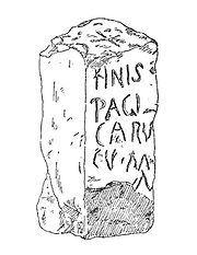 Boundary marker of the Pagus Carucum.
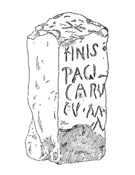
A Roman era boundary marker has been found near Neidenbach bei Kyllburg marked "FINIS PAGI CARV CVM" (the boundary or end of the Carucum pagus). This was on the Roman road between Trier, the main Roman city of the Treverii, and Cologne.
This was a wooded area, forming a boundary between regions. To the east of Neidenbach, the Vinxtbach, a small river flowing eastwards to the Rhine, marked the boundary between the Roman provinces of Germania Superior and Germania Inferior. The name Vinxtbach is in fact thought to derive from the Latin word finis, meaning an end or boundary. Today the Vinxtbach is still a boundary between modern German dialects, with Ripuarian to the north, and Moselle Frankish to the south. Also nearby is the modern boundary of modern German Länder of Rheinland-Pfalz and Nordrhein-Westfalen.
Their name is believed to mean "sheep people", and to be Celtic in origin.[4]
References
- ^ "Histories" 4.70.
- ^ Julius Caesar, Commentarii de Bello Gallico 2.4 and 6.32
- ^ Tacitus, Germania, II 2. ceterum Germaniae vocabulum recens et nuper additum, quoniamqui primi Rhenum transgressi Gallos expulerint ac nunc Tungri, tunc Germani vocati sint: ita nationis nomen, nongentis, evaluisse paulatim, ut omnes primum a victore obmetum, mox et a se ipsis invento nomine Germani vocarentur.
- ^ a b Wightman, Edith Mary (1985), Gallia Belgica, University of California Press, http://books.google.com/books?id=aEyS54uSj88C, page 31.
External links
Belgica Ambiani · Atrebates · Atuatuci · Bellovaci · Caeroesi · Catalauni · Condrusi · Eburones · Leuci · Mediomatrici · Menapii · Morini · Nervii · Paemani · Remi · Segni · Silvanectes · Suessiones · Toxandri · Treveri · Vellocasses · Viromandui

Celtica Abrincatui Aedui · Ambarri · Andes (Andecavi) · Arverni · Baiocasses · Bituriges Cubi · Cadurci · Caletes · Carnutes · Caturiges · Cenomani · Curiosolitae · Diablintes · Eburovices · Esuvii · Gabali · Helvetii · Lemovici · Lexovii · Lingones · Meldi · Namnetes · Nitiobriges · Osismii · Parisii · Petrocorii · Pictones · Redones · Ruteni · Santones · Senones · Segusiavi · Sequani · Tricasses · Turones · Unelli · Vellavi · Veneti · ViducassesAquitania Narbonensis Allobroges · Arecomici · Cavares · Caturiges · Ceutrones · Deciates · Helvii · Nantuates · Salluvii · Volcae (Arecomici and Tectosages) · Tricastini · VocontiiGermanic peoples Languages Prehistory Roman Iron Age Migration Period Germanic Iron Age · Alamanni · Anglo-Saxons (Angles · Jutes · Saxons) · Burgundians · Dani · Franks · Frisii · Geats · Goths (Visigoths · Ostrogoths · Valagoths · Gothic Wars) · Gotlanders · Lombards · Suebi · Suiones · Vandals · Varangians · Christianization of the Germanic peoples · RomanizationSociety and culture Mead hall · Poetry · Migration Period art · Runes (Runic calendar) · Sippe · Law (Lawspeaker · Thing) · Calendar · King · Names · Numbers · Romano-Germanic cultureReligion Wodanaz · Veleda · Tuisto · Mannus · Paganism (Anglo-Saxon · Continental Germanic mythology · Frankish · Norse) · Christianity (Arianism · Gothic)Dress Warfare Burial practices Categories:- Ancient peoples
- Ancient Germanic peoples
- Germanic peoples
- Ethnic groups in Europe
- History of the Germanic peoples
- Iron Age Europe
- Tribes of ancient Gaul
- Tribes involved in the Gallic Wars

Wikimedia Foundation. 2010.