- Eastville, Bristol
-
Coordinates: 51°28′30″N 2°33′27″W / 51.4750°N 2.5574°W
Eastville 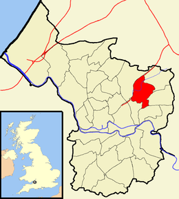
Boundaries of the city council ward.Population 10,852 [1] OS grid reference ST613752 Unitary authority Bristol Ceremonial county Bristol Region South West Country England Sovereign state United Kingdom Post town BRISTOL Postcode district BS5 Dialling code 0117 Police Avon and Somerset Fire Avon Ambulance Great Western EU Parliament South West England UK Parliament Bristol East List of places: UK • England • Bristol Eastville is the name of both a council ward in the city of Bristol in the United Kingdom and a suburb of the city that lies within that ward. The Eastville ward covers the areas of Eastville, Crofts End (also known as Clay Hill), Stapleton and part of Fishponds. Notable places within the ward include Bristol Metropolitan College ( formerly Whitefield Fishponds Community School) and Colston's School, and the Bristol & Bath Railway Path also passes through the ward.[2]
Contents
Eastville
 Eastville Park
Eastville is an inner-suburb of the English city of Bristol, situated between Lower Easton and Whitehall/Fishponds in the central north of the city. In the west its boundary is the River Frome (or the M32 motorway, which follows a similar route).
Eastville Stadium (on the west bank of the Frome) used to be the home of Bristol Rovers Football Club, as well as being a site for greyhound racing and speedway, but this site has now been developed by IKEA.
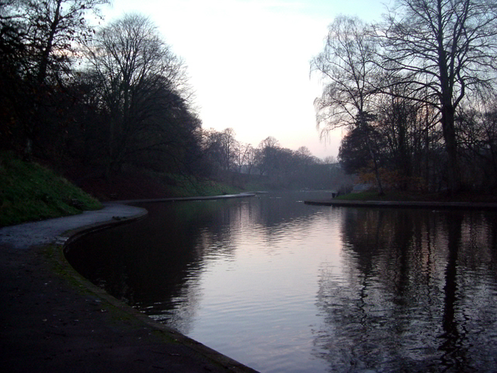
Eastville Park is a large park with a small lake, just to the east of the M32.[3] The lake at Eastville Park was instigated as part of a social scheme by Ernest Bevin (a well-respected westcountryman), who later became Minister of Labour under Churchill in the coalition government of WW2 and later Foreign Secretary in the Attlee Government from 1945 until his death.
A large railway viaduct known as 'The Thirteen Arches' for obvious reasons, once ran through the area, roughly parallel to the current Muller Road. This was part of the Clifton Extension Railway.
Eastville Workhouse was a former French Prison which was brought from the Government circa 1832, In 1930, the Stapleton workhouse became Stapleton Institution and by the Second World War the site was mainly used for the care of the mentally ill. It was bombed in 1940; the centre of the site is now May Park Primary School.
Pubs and bars in Eastville
There are four pubs officially designated as in Eastville. Each of them dates back at least to the reign of Queen Victoria. The Coach House was originally called The Beaufort Inn, and subsequently the Railway Tavern, while the Black Swan was licensed during the reign of King George IV. The White Lion was licensed to a John Williams as early as 1877, while the Queen's Head has perched above Eastville Park since the late 19th century. Many other pubs were sited in Eastville, but all have now been demolished or converted to other uses.
Crofts End
Crofts End (also known as Clay Hill) is a suburb of Bristol. It is an industrialised area, with many small Victorian houses, built when this area was a coal mining community.
Churches
Crofts End Church was established in 1895 by George Brown, as a Christian work for miner's children in The Freestone Rank, Whitehall Road, it became known as The Miner's Mission. It is now part of the local and much wider community but still very much a family church. The pastor is Andrew Yelland.[4]
The church was built on a site bounded by market gardens, a brick works and Deep Pit Colliery. When The Beaufort Arms, then known as The Beatem and Wackem and now called The Wackum Inn was the place where most miners spent their hard earned wages! Hence the need for a children's work in that community.
Another local church was Clay Hill Chapel which was demolished when the industrial estates were built.
Industry
Over many years, the Market Gardens became housing, White's Brick Works became Somers Wood Yard (now an industrial pallet site) - where many older people will remember going as children to collect a sack or trolley full of firewood - and Deep Pit Colliery became industrial estates. When Deep Pit closed, men were having to walk underground as far as Frenchay, to reach the coal face!
Housing
Crofts End House, located at the junction of Plummer's Hill and Whitehall Avenue, still exists, but no longer as a single dwelling. It has been refurbished and is now part of a housing association development.
The area is undergoing more change as the majority of 'prefabs' (built by American Service-men as post war housing) in the locality have been demolished. Planning applications will replace these with mixed style housing.
The old, redundant Civil Defence building on the junction of Crofts End Road and Brook Road was demolished and housing association flats were built on the site, now named "Craftes Court"
Fishponds
Fishponds is a predominantly residential area of Bristol that lies partially within the Eastville ward.
Stapleton
Stapleton is a suburb of Bristol which lies in the east of the city.
References
- ^ "Eastville". 2001 Census Ward Information Sheet. http://www.bristol.gov.uk/WardFinder/pdfs/eastville-wis.pdf. Retrieved 2007-02-21.
- ^ Bristol City Council. "Eastville map" (PDF). Ward Finder. http://www.bristol.gov.uk/WardFinder/pdfs/eastvillemap-high.pdf. Retrieved 2007-11-08.
- ^ Factsheet - Eastville Park. Avon Gardens Trust. http://www.parkdetectives.org/pdfs/ep-factsheet.pdf. Retrieved 2009-03-19.
- ^ "Crofts End Church". http://www.croftsend.org. Retrieved 2006-10-25.
Categories:- Districts of Bristol
- Wards of Bristol

Wikimedia Foundation. 2010.