- Clifton Extension Railway
-
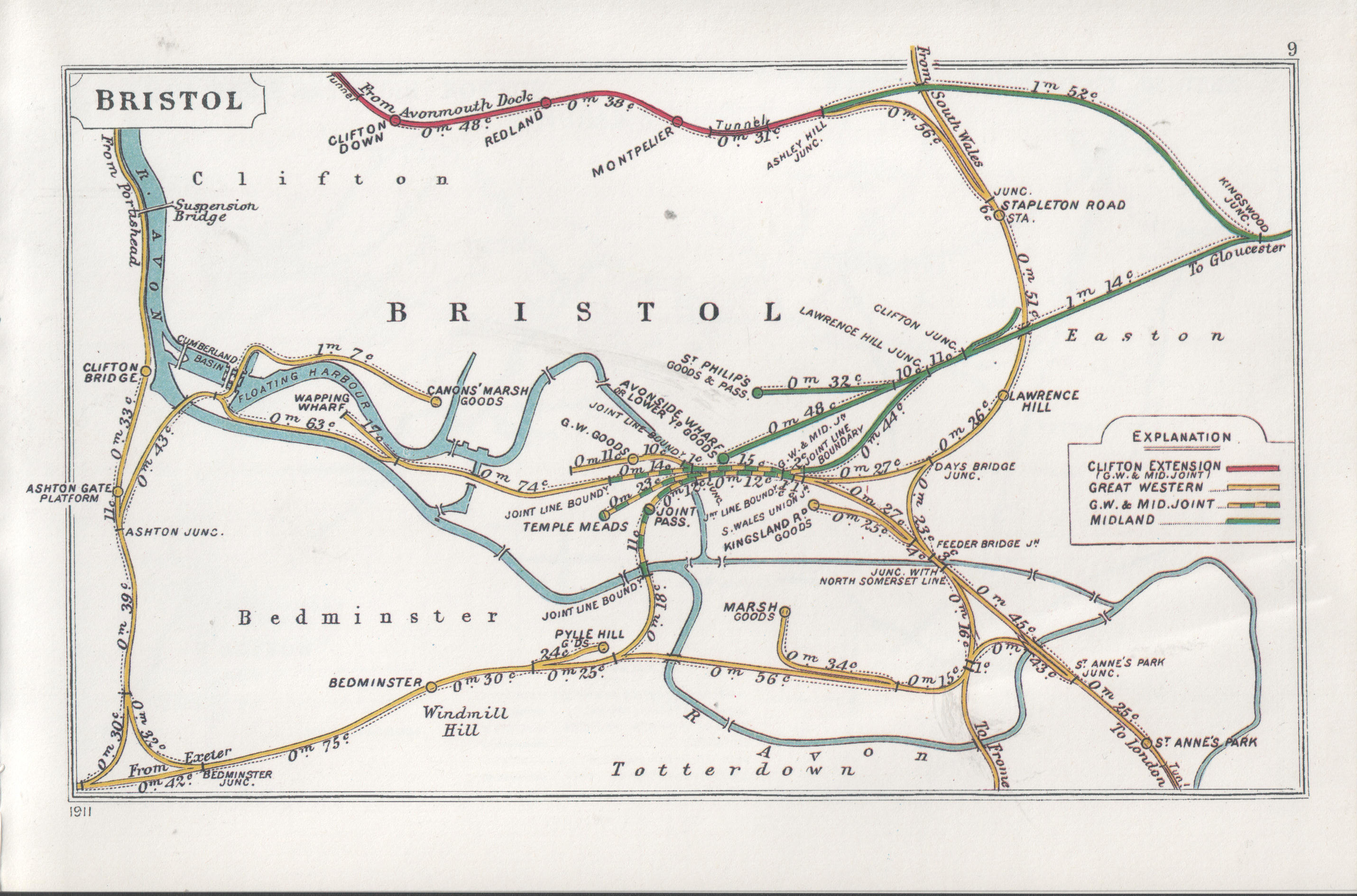
 Clifton Extension Railway runs along the top of this 1911 Bristol railway map
The Clifton Extension Railway was a joint railway in Bristol, owned by the Great Western Railway (GWR) and the Midland Railway (MR) companies.
Contents
Description of line
The railway ran from a junction with the GWR at Narroways Hill, just north of Stapleton Road railway station, to Avonmouth Docks. The branch was joined at Ashley Hill junction, just beyond Narroways Hill, by a line which left the Midland main line at Kingswood Junction, south-west of Fishponds station.
The first section of line through Montpelier to Clifton Down opened on 1 October 1874. The greatest engineering feature of the branch was a mile-long tunnel underneath Clifton Down. The section through the tunnel from Clifton Down station to Sneyd Park Junction, where it connected to the Bristol Port Railway, opened to goods traffic in 1877 and to passenger trains on 1 September 1885.[1]
Legal history
Originally the railway was promoted by the Bristol Port Railway and Pier Company, incorporated under the Bristol Port Railway and Pier Act of 17 June 1862. In 1871 the railway was transferred to the Great Western and Midland railway companies jointly, under the Great Western and Midland railway companies (Clifton and Bristol) Act of 25 May 1871, and the Midland Railway (Additional Powers) Act of 25 July 1890. The line was administered by the Clifton Extension Railway Joint Committee until 1894, and from then the Great Western and Midland Railways Joint Committee.[2]
Recent history
Severn Beach Line detailed map Legend

South Wales Main Line 


Pilning 
Cross Hands Halt 


River Severn 


New Passage Pier 
New Passage Halt 
Severn Tunnel 


South Wales Main Line 
Station Road 
Severn Beach 


A403 Severn Road 

Border of Bristol 


Henbury Loop 


A403 St Andrew's Road 

Kings Weston Lane Stores Road 
Zinc Road 


St Andrew's Road 


Avonmouth Docks 


Avonmouth 


Victoria Road River Severn 

M5 Avonmouth Bridge 
Portway (proposed) Station Road Shirehampton Hung Road 
Woodwell Road 
River Trym Sea Mills 
A4 Portway 
Sneyd Park Junction Clifton Down Tunnel (1751 yds) 
Circular Road 
Hotwells Halt Ladies Mile 
Hotwells River Avon 
A4176 Clifton Down B4467 Pembroke Road Downfield Road Apsley Road Beaufort Road Duchess Road 
Clifton Down Tunnel (1751 yds) St John's Road 
Clifton Down A4018 Whiteladies Road Hampton Park Hampton Road Redland Grove Redland Redland Road 
Kingsley Road 
A38 Cheltenham Road 
Montpelier St Andrew's Road Montpelier Tunnel (288 yds) 
B4052 Ashley Road 
Cross Country Route 
Mina Road 

Midland Railway 


Narroways Junction James Street 
M32 motorway A432 Stapleton Road Stapleton Road St Mark's Road Bannerman Road B4465 Easton Road 

Midland Railway 

To waste depot Lawrence Hill A420 Church Road Ducie Road Barton Hill Road Dr Days Junction Silverthorne Lane 
Great Western Main Line 

A4320 St Philips Causeway Silverthorne Lane 
Temple Meads Goods Depot 
Kingsland Road Gas Lane Avon Street 
Bristol Docks 

Bristol Temple Meads Cattle Market Road River Avon 
Bristol to Taunton Line The line from Narroways Hill is now part of the Severn Beach Line.
The connection to the Midland Railway closed in 1965, and the thirteen arch viaduct over the River Frome valley was demolished in 1968.[3]
References
- ^ Maggs, C. (1981) Rail Centres: Bristol Ian Allan ISBN 0-7110-1153-2
- ^ "Series reference RAIL 81 - Bristol Port Railway and Pier Company (including Clifton Extension Railway)". National Archives. http://www.nationalarchives.gov.uk/catalogue/DisplayCatalogueDetails.asp?CATID=11056&CATLN=3&FullDetails=True. Retrieved 21 April 2011.
- ^ Viaduct Demolished. British Pathe. 26 May 1968. 3311.14 / UN 4356 C. http://www.britishpathe.com/record.php?id=73140. Retrieved 21 April 2011.

This United Kingdom rail transport related article is a stub. You can help Wikipedia by expanding it.