- Dayton, Minnesota
-
Dayton, Minnesota — City — Location in Hennepin County, Minnesota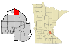
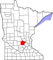
Coordinates: 45°11′47″N 93°28′51″W / 45.19639°N 93.48083°W Country United States State Minnesota Counties Hennepin, Wright Founded Incorporated Government - Mayor Douglas Anderson Area - City 25.2 sq mi (65.2 km2) - Land 23.5 sq mi (60.7 km2) - Water 1.7 sq mi (4.4 km2) Elevation 879 ft (268 m) Population (2010)[1] - City 4,671 - Density 200.4/sq mi (77.4/km2) - Metro 2,968,805 Time zone Central (UTC-6) - Summer (DST) Central (UTC-5) ZIP codes 55327, 55369 Area code(s) 763 FIPS code 27-15022[2] GNIS feature ID 0642665[3] Website www.cityofdaytonmn.com Dayton is a city in Hennepin and Wright counties in the U.S. state of Minnesota. The population was 4,671 at the 2010 census.[1] Dayton is mainly in Hennepin County, but a part of the city extends into Wright County as well. It is the northernmost city in Hennepin County.
The city of Dayton, platted in 1855, is named for city founder, Lyman Dayton (1810–1865). Through his energy and finances, Lyman Dayton was instrumental in bringing the railroad into Minnesota and development of the Lake Superior and Mississippi Railroad, of which he was President until 1865.[4]
Contents
Geography
According to the United States Census Bureau, the city has a total area of 25.2 square miles (65.2 km²), of which, 23.5 square miles (60.7 km²) of it is land and 1.7 square miles (4.5 km²) of it (6.83%) is water. On January 15, 2003 the city's most recent geographical expanse extended its boundaries. County Roads 121 and 144 are two of the main routes in the city. The neighboring cities are Champlin, Hassan Township, Maple Grove, Anoka, Ramsey, Elk River, and Otsego. The cities of Rogers and Corcoran are nearby, but do not border Dayton.
Dayton is located at the confluence of the Mississippi and Crow Rivers.
Economy
Dayton is a small town in regards to the economy scale with few retail outlets. Dayton's economy comes from mostly small business operations such as four golf courses, various car repair shops, famous local manor, and custom home builders. It is also home to a PDQ convenience store.
Demographics
As of the census[2] of 2000, there were 4,699 people, 1,550 households, and 1,292 families residing in the city. The population density was 200.4 people per square mile (77.4/km²). There were 1,566 housing units at an average density of 66.8 per square mile (25.8/km²). The racial makeup of the city was 95.28% White, 0.64% African American, 0.64% Native American, 0.81% Asian, 1.87% from other races, and 0.77% from two or more races. Hispanic or Latino of any race were 2.75% of the population. 31.6% were of German, 13.5% Swedish, 11.0% Norwegian and 7.9% Irish ancestry according to Census 2000.
There were 1,550 households out of which 45.7% had children under the age of 18 living with them, 71.9% were married couples living together, 7.9% had a female householder with no husband present, and 16.6% were non-families. 11.7% of all households were made up of individuals and 2.1% had someone living alone who was 65 years of age or older. The average household size was 3.03 and the average family size was 3.29.
In the city the population was spread out with 30.5% under the age of 18, 7.8% from 18 to 24, 33.2% from 25 to 44, 23.7% from 45 to 64, and 4.7% who were 65 years of age or older. The median age was 35 years. For every 100 females there were 103.1 males. For every 100 females age 18 and over, there were 105.1 males.
The median income for a household in the city was $66,875, and the median income for a family was $71,356. Males had a median income of $41,476 versus $30,386 for females. The per capita income for the city was $27,756. About 1.0% of families and 2.7% of the population were below the poverty line, including 3.7% of those under age 18 and none of those age 65 or over.
Points of interest
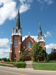 St. John The Baptist Catholic Church, July 2009
St. John the Baptist Catholic Church, constructed in 1904, is perched atop the highest hill in the city and can be seen for miles and from four different counties.
References
- ^ a b "2010 Census Redistricting Data (Public Law 94-171) Summary File". American FactFinder. U.S. Census Bureau, 2010 Census. http://factfinder2.census.gov/faces/tableservices/jsf/pages/productview.xhtml?pid=DEC_10_PL_GCTPL2.ST13&prodType=table. Retrieved 23 April 2011.
- ^ a b "American FactFinder". United States Census Bureau. http://factfinder.census.gov. Retrieved 2008-01-31.
- ^ "US Board on Geographic Names". United States Geological Survey. 2007-10-25. http://geonames.usgs.gov. Retrieved 2008-01-31.
- ^ Upham, Warren, "Minnesota Geographic Names, Their Origin and Historic Significance", St. Paul: Minnesota Historical Society, printed in 1920 and again in 1969, pages 221 and 393.
External links
Municipalities and communities of Hennepin County, Minnesota Cities Bloomington | Brooklyn Center | Brooklyn Park | Champlin | Chanhassen‡ | Corcoran | Crystal | Dayton‡ | Deephaven | Eden Prairie | Edina | Excelsior | Golden Valley | Greenfield | Greenwood | Hanover‡ | Hopkins | Independence | Long Lake | Loretto | Maple Grove | Maple Plain | Medicine Lake | Medina | Minneapolis | Minnetonka | Minnetonka Beach | Minnetrista | Mound | New Hope | Orono | Osseo | Plymouth | Richfield | Robbinsdale | Rockford‡ | Rogers | Shorewood | Spring Park | St. Anthony‡ | St. Bonifacius | St. Louis Park | Tonka Bay | Wayzata | Woodland

Township Unorganized
territoryFootnotes ‡This populated place also has portions in an adjacent county or counties
Municipalities and communities of Wright County, Minnesota Cities Albertville | Annandale | Buffalo | Clearwater‡ | Cokato | Dayton‡ | Delano | Hanover‡ | Howard Lake | Maple Lake | Monticello | Montrose | Otsego | Rockford‡ | St. Michael | South Haven | Waverly
Townships Albion | Buffalo | Chatham | Clearwater | Cokato | Corinna | Franklin | French Lake | Maple Lake | Marysville | Middleville | Monticello | Rockford | Silver Creek | Southside | Stockholm | Victor | Woodland
Unincorporated
communitySilver Creek
Ghost town Footnotes ‡This populated place also has portions in an adjacent county or counties
Categories:- Populated places in Hennepin County, Minnesota
- Populated places in Wright County, Minnesota
- Cities in Minnesota
- Minnesota populated places on the Mississippi River
- Populated places established in 1855


Wikimedia Foundation. 2010.