- Israel Putnam Wolf Den
-
Israel Putnam Wolf Den

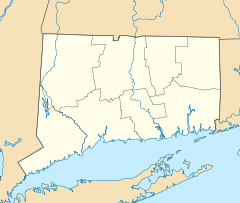
Location: Pomfret, Connecticut Coordinates: 41°50′36″N 71°59′4″W / 41.84333°N 71.98444°WCoordinates: 41°50′36″N 71°59′4″W / 41.84333°N 71.98444°W Built: 1742 Governing body: State NRHP Reference#: 85000949
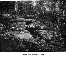
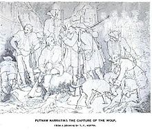
[1]Added to NRHP: May 2, 1985 Israel Putnam Wolf Den is an historic site off Wolf Den Road in Pomfret, Connecticut. At this location in 1742, Israel Putnam shot and killed Connecticut's last known wolf.[2] The site is maintained as a state park and was added to the National Register of Historic Places in 1985.[3]
References
- ^ "National Register Information System". National Register of Historic Places. National Park Service. 2008-04-15. http://nrhp.focus.nps.gov/natreg/docs/All_Data.html.
- ^ Jill Knight Weinberger (June 2, 2002). "Touring the Quiet Corner". The New York Times. http://query.nytimes.com/gst/fullpage.html?res=9E0DE2D7163BF931A35755C0A9649C8B63&sec=travel&spon=&pagewanted=2. Retrieved 2009-02-26.
- ^ "Military& Adventure:Israel Putnam". Connecticut Military Department. January 29, 2004. http://www.ct.gov/mil/cwp/view.asp?a=1351&q=258410. Retrieved 2009-02-26.
Protected areas of Connecticut National Park Service National Wildlife Refuges Silvio O. Conte • Stewart B. McKinney National Wildlife Refuge
National Trails State Parks Airline • Beckley Iron Furnace Industrial Monument • Bigelow Hollow • Black Rock • Bluff Point • Burr Pond • Camp Columbia • Campbell Falls • Chatfield Hollow • Collis P. Huntington • Connecticut Valley Railroad • Day Pond • Dennis Hill • Devil's Hopyard • Dinosaur • Fort Griswold Battlefield • Fort Trumbull • Gardner Lake • Gay City • George W. Seymour • Gillette Castle • Haddam Meadows • Haley Farm • Hammonasset Beach • Hampton Beach • Harkness Memorial • Haystack Mountain • Hop River State Park Trail • Hopeville Pond • Housatonic Meadows • Hurd • Indian Well • John A. Minetto • Kent Falls • Kettletown • Lake Waramaug • Larkin State Park Trail • Levy • Lovers Leap • Macedonia Brook • Mansfield Hollow • Mashamoquet Brook • Millers Pond • Mohawk Mountain • Moosup Valley State Park Trail • Mount Tom • Old Furnace • Osbornedale • Penwood • Putnam Memorial • Quaddick • Quinnipiac River • River Highlands • Rocky Neck • Selden Neck • Seth Low Pierrepont • Sherwood Island • Silver Sands • Sleeping Giant • Southford Falls • Squantz Pond • Stratton Brook • Talcott Mountain • Wadsworth Falls • West Rock Ridge • Wharton Brook • Windsor Locks Canal State Park Trail
State Forests Algonquin • American Legion • Centennial Watershed • Cockaponset • Enders • James L. Goodwin • Housatonic • Massacoe • Mattatuck • Meshomasic • Mohawk • Mohegan • Nassahegon • Natchaug • Nathan Hale • Nehantic • Nepaug • Nipmuck • Nye-Holman • Pachaug • Paugnut • People's • Pootatuck • Quaddick • Salmon River • Shenipsit • Topsmead • Tunxis • Wyantenock
Connecticut Department of Environmental Protection (web)U.S. National Register of Historic Places Topics Lists by states Alabama • Alaska • Arizona • Arkansas • California • Colorado • Connecticut • Delaware • Florida • Georgia • Hawaii • Idaho • Illinois • Indiana • Iowa • Kansas • Kentucky • Louisiana • Maine • Maryland • Massachusetts • Michigan • Minnesota • Mississippi • Missouri • Montana • Nebraska • Nevada • New Hampshire • New Jersey • New Mexico • New York • North Carolina • North Dakota • Ohio • Oklahoma • Oregon • Pennsylvania • Rhode Island • South Carolina • South Dakota • Tennessee • Texas • Utah • Vermont • Virginia • Washington • West Virginia • Wisconsin • WyomingLists by territories Lists by associated states Other Categories:- National Register of Historic Places in Connecticut
- Pomfret, Connecticut
- Protected areas established in 1899
- Connecticut Registered Historic Place stubs
Wikimedia Foundation. 2010.


