- Fort Ord
-
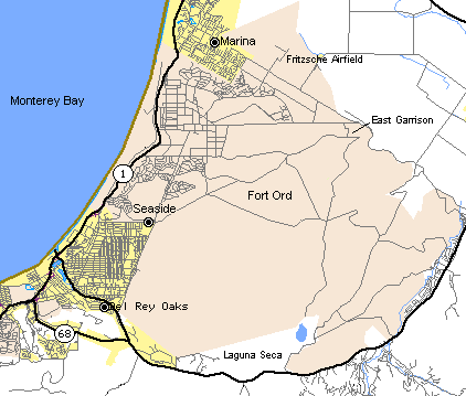
Fort Ord Monterey Bay area, California 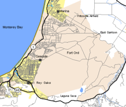
Type Army Post Coordinates Coordinates: 36°38′21″N 121°44′07″W / 36.6391667°N 121.7352778°W Built 1917 In use 1917 - 1994 Fort Ord was a U.S. Army post on Monterey Bay in California. It was established in 1917 as a maneuver area and field artillery target range and was closed in September 1994. Fort Ord was one of the most attractive locations of any U.S. Army post, because of its proximity to the beach and California weather. The 7th Infantry Division (Light) was its main resident for many years. When Fort Ord was converted to civilian use, space was set aside for the first nature reserve in the United States created for conservation of an insect, the endangered species Smith's blue butterfly.
While much of the old military buildings and infrastructure remain abandoned, many structures have been torn down for anticipated development. California State University Monterey Bay and Fort Ord Dunes State Park, along with some subdivisions, the Veterans Transition Center, a strip mall, military facilities and a nature preserve occupy the area today.
Contents
History

In 1917, land was purchased just north of the city of Monterey for use as an artillery training field for the Army. The area was known as the Gigling Reservation, U.S. Field Artillery Area, Presidio of Monterey and Gigling Field Artillery Range.
In 1933, the artillery field became Camp Ord, named in honor of Maj. Gen. Edward Ord, a Union Army leader during the American Civil War who also served in the Second Seminole War and Indian Wars. Primarily, horse cavalry units trained on the camp until the military began to mechanize and train mobile combat units.
In 1940, the 23-year-old Camp Ord was expanded to 2,000 acres (8.1 km2; 3.1 sq mi). In August 1940, it was re-designated Fort Ord and the 7th Infantry Division was reactivated, becoming the first major unit to occupy the post.
In 1941, Camp Ord became Fort Ord. For the next thirty years, the fort was the primary facility for basic training for the Army.
In 1947, Fort Ord became the home of the 4th Replacement Training Center. During the 1950s and 1960s, Fort Ord was a staging area for units departing for war, and at one time had 50,000 troops on the installation. The 194th Armored Brigade was activated there under Combat Development Command in 1957, but departed for Fort Knox in 1960.
In 1957, land on the eastern side of the post was used to create the Laguna Seca Raceway which served to replace the Pebble Beach road racing course that ceased operations for safety reasons in that same year.
The post continued as a center for instruction of basic and advanced infantrymen until 1976, when the training area was deactivated and Fort Ord again became the home of the 7th Infantry Division, following their return from South Korea after twenty-five years on the DMZ.
In 1988, Base Realignment and Closure (BRAC) legislation was passed by Congress.
In 1991, the decision to close Fort Ord was made.
In 1994, Fort Ord was officially closed. The fort was the largest U.S. military base to be closed at the time.
During the last few years, basic training for National Guard and Reservists was conducted by regular army personnel, but there was a shift at that time to focus on the mental and emotional, as well as the traditional physical aspects of basic training. This was done to prepare the Guard and Reservists to better handle the unique challenges of serving in the domestic "theatre," acknowledging the unique mental and emotional stresses inherent in a typical reservist deployments.
Closing the Fort
The BRAC Commission of 1991 recommended closing the post and moving the units stationed at Fort Ord to Fort Lewis, Washington. In 1992, Army elements from Fort Ord and Marines from Camp Pendleton participated in quelling the 1992 Los Angeles Riots. In 1994 Fort Ord was finally closed. Most of the land was returned to the state of California and became the home of the California State University, Monterey Bay. The remainder was given to UC Santa Cruz to be developed into the UC MBEST (Monterey Bay Education, Science and Technology) Center. The MBEST Center is a regional economic development effort focused on developing collaborative research-business opportunities in the Monterey Bay region.
The city of Marina is developing a large part of land within its city limits, building over 1,000 new homes. A large strip mall along Highway 1 at the former north entrance to Fort Ord opened in late 2007, housing popular retail stores such as Target, R.E.I., Michaels, Old Navy, Kohl's, and Best Buy. A substantial amount of land on the east side of the base has been set aside for preservation as open space. This preserve includes a network of hiking trails and other recreational amenities.
After some 77 years of military use, the base was found to be highly and widely contaminated with toxic materials including lead from bullets at the beach rifle training ranges, unexploded ordnance (UXO) spread across more than 10,000 acres of impact ranges, and unlined landfills leaking trichloroethane and carbon tetrachloride into ground water under residential areas, some detected in drinking water wells. This contamination finding resulted in Fort Ord's placement on the National Priorities List, a subset of the most contaminated Superfund sites.
The subsequent cleanup was controversial soon after it started, drawing lawsuits from the Regional Air Quality protection agency and one of the three non-profits formed specifically to force the Army and the Environmental Protection Agency to adequately and responsibly clean up the toxics and explosives. The beach area, which became Fort Ord Dunes State Park in 2009, still contains extensive lead dust which can harm children's health with lead poisoning because 96 percent of the area was not cleaned up. (Post-Remediation Health and Ecological Risk Assessments, 2007)
Fort Ord's former golf courses, Bayonet and Black Horse, are now public golf courses. They have hosted PGA golf events and were recently renovated.[1]
A small portion of Ft. Ord remains under Army control and is now called the Presidio of Monterey Annex. It includes the Ord Military Community (explained below), California National Guard posts, the DoD Center, and the gunnery ranges.
The military still has a presence at Fort Ord, in the form of several California Army National Guard units, facilities administered by the Presidio of Monterey, and the continued operation of the base PX and Commissary catering to the active duty military stationed in the Monterey area as well as retirees who chose to settle in the area and are entitled to shop at such facilities. Management of the military housing has been outsourced to private firms, but the homes are still occupied by personnel stationed at the Presidio of Monterey and Naval Postgraduate School and retired military members. Ft. Ord's housing, PX, chapel, and Commissary are now called Ord Military Community.
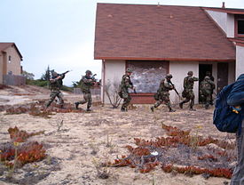 A snapshot taken during a "Secrets of Fort Ord" Tour, with real soldiers training in progress.
Recent events
In June 2006, Ed Salven, one of Ft. Ord's veterans from the Vietnam era, published a book, The Soldier Factory, chronicling his personal history as a soldier, and reflecting upon a return visit to the Fort in the late '90s. Along with poetic reflections, the book includes color reproductions of paintings of soldiers that Salven found hung from barracks' windows as he explored the grounds, rendered by students from California State University, Monterey Bay.
An annual "Secrets of Fort Ord" tour is given, beginning from the campus of CSUMB. Locations are reached by bus, and the tour takes approximately two hours. Though much of the fort appears abandoned, tourists learn otherwise upon seeing the buildings in full use with soldiers in training within the broken down buildings. Much of the tour takes place beyond public reach, behind closed off limit areas. Some places are only viewable from the outside, though, such as the former prison, recently used for paintball and airsoft competitions, now house a concrete works and other industry.
The Marina Equestrian Center by the stockade has a fascinating history,[2] having started as an equine veterinary hospital in 1941 to serve the 1400 horses of the 76th Field Artillery Regiment (United States). Community horse boarding and prime riding-trail access on BLM land is still available, but is in danger of being eliminated by the City of Marina. This is the only remaining example of a major World War II-construction medical facility for warhorses. Twelve of the original twenty-one stables built to house the warhorses and mules in 1940 are about 200 yards away from the equestrian center, on Fourth Avenue/Gen Jim Moore Blvd. They are owned by CSUMB and slated for demolition.
Several other abandoned locations which may or may not have been included in the tour, and which may have even been knocked down as of 2007, include the Doughboy Theater, an Olympic sized swimming pool, a bowling alley, and an incinerator.
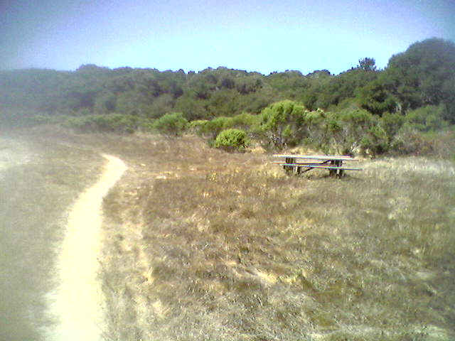
 A view of some of Fort Ord's Public Lands.
Veterans Transition Center
The Veterans Transition Center (VTC) is also located on the site of the former Ford Ord. Since its inception it has served 4,155 single veterans and 351 veterans with families. The center is currently looking to expand by adding more housing units and a non-profit store (to be run by partner company, Vocational Rehabilitation Specialists Inc.) with the express purpose of employing as many veterans as possible.[3][4]
California State University, Monterey Bay
California State University, Monterey Bay opened on the Fort's former ground shortly after Fort Ord's closing as part of President Bill Clinton's peace dividends program. The University has a currently enrolled of roughly 4,500 students and the Leon Penetta Institute is located on its campus.
Fort Ord Dunes State Park and Public Lands
At the end of the same street that the DOD Building sits is one of many entrances to the Fort Ord Public Lands, which includes miles of trails, vegetation and wildlife. As their title states, the trails are open to the public for hiking, biking, and other forms of exercise. However, many trails are fenced along their edges because of possible unexploded ordnance.
A coastal strip overlooking Monterey Bay became California's newest state park, Fort Ord Dunes State Park, in 2009.[5]
Fort Ord Public Lands refers to that land on the former Fort Ord that is administered by the Bureau of Land Management(BLM) www.blm.gov and is open to the general public. Prior to being made available to the public, the land underwent a comprehensive remediation process that involved an extensive munitions clean-up. Currently there are over 83 miles (134 km) of recreational trails available on Fort Ord. Those trails are used by representatives from the trail communities including those on foot, on bicycles and on horseback. All open trails are available to all non-motorized trail user groups. The BLM sponsors a group of volunteers who patrol the trails as hikers, cyclist and equestrians. The group is named Ft Ord BETA - Bicycle Equestrian Trails Assistance. www.ftordbeta.org All members of BETA are trained in first-aid and CPR. Members are also familiar with the trails and trail features.
Notable Fort Ordians
- Some who served or lived at Ft. Ord
- Michelle Boulos, nationally competitive figure skater
- Clint Eastwood, actor & director
- Jerry Garcia, musician and co-founder of the Grateful Dead
- David Janssen, actor
- Scott Melville, professional tennis player
- Martin Milner, actor
- Lt. Gen. Hal Moore, revered general officer and author (he was portrayed by Mel Gibson in screen adaptation of his book)
- Matthew Morrison, actor & singer
- Steve Owens, Heisman Trophy winner, 1969
- Alan Osmond, singer, musician, performer and leader of The Osmonds
- Wally Rank, professional basketball player
- John Saxon (actor)
- Ron Rivera, current head coach of the NFL's Carolina Panthers
- Gen. Joseph Stilwell, World War II commander known as "Vinegar Joe" who won acclaim in China and Burma campaigns
- Maj. Gen. Charles H. Swannack, Jr., battalion commander who went on to command the 82nd Airborne Division
- Brig. Gen. Huba Wass de Czege, one of the Army's leading strategists in the 1980s
- Jimi Hendrix, Musician. Was at Ft. Ord in May 1961 for three months basic training
In popular culture
- The 1956 movie, The Girl He Left Behind, with Tab Hunter and Natalie Wood, was filmed at Ft. Ord.
- The 1980 movie "Private Benjamin" featured an attractive photo of moored yachts at Fort Ord during a recruitment scene being used as an inducement.
- The TV series MythBusters frequently uses the streets of an abandoned housing development in Fort Ord for testing that involves driving a car.[6]
See also
Notes
- ^ SeeMonterey: Bayonet and Black Horse
- ^ "The Fort Ord Equestrian Center". http://freepages.genealogy.rootsweb.ancestry.com/~gregkrenzelok/veterinary%20corp%20in%20ww1/fort%20ordequestriancenter.html. Retrieved June 21, 2010.
- ^ Townsell, T. K. (2009). Monterey Area Veterans Transition Center offers assistance to all local vets. Retrieved 04-11-2011 from www.army.mil, the official homepage of the U.S. Army: http://www.army.mil/-news/2009/12/10/31701-monterey-area-veterans-transition-center-offers-assistance-to-all-local-vets/
- ^ HelpVTC. 2011. About VTC: http://www.helpvtc.org/About.html
- ^ Cooper, J. Fort Ord Dunes now a state park. San Francisco Chronicle January 24, 2010
- ^ Mythbusters, viewed April 9, 2010.
External links
- Army's Fort Ord Environmental Cleanup Website
- GlobalSecurity.org
- Fort Ord, California - History & Photos
- Fort Ord Reuse Authority
- Fort Ord BETA-Bicycle Equestrian Trail Assistance
The California State University
Est. 1857Campuses Bakersfield • Channel Islands • Chico • Dominguez Hills • East Bay • Fresno • Fullerton • Humboldt • Long Beach • Los Angeles • Maritime • Monterey Bay • Northridge • Pomona • Sacramento • San Bernardino • San Diego • San Francisco • San Jose • San Luis Obispo • San Marcos • Sonoma • Stanislaus
Research and academics History Vox Veritas VitaMunicipalities and communities of Monterey County, California Cities Carmel-by-the-Sea | Del Rey Oaks | Gonzales | Greenfield | King City | Marina | Monterey | Pacific Grove | Salinas | Sand City | Seaside | Soledad
CDPs Aromas‡ | Boronda | Bradley | Carmel Valley Village | Castroville | Chualar | Del Monte Forest | Elkhorn | Las Lomas | Lockwood | Moss Landing | Pajaro | Pine Canyon | Prunedale | San Ardo | San Lucas | Spreckels
Unincorporated
communitiesAmbler Park | Blanco | Bolsa Knolls | Bryson | Camphora | Carmel Highlands | Coburn | Confederate Corners | Cooper | Corral de Tierra | Dean | Del Monte | East Garrison | Elsa | Fort Romie | Gabilan Acres | Gorda | Harlem | Jamesburg | Jolon | Lonoak | Lucia | Martinus Corner | Metz | Molus | Moss | Nacimiento | Nashua | Natividad | Neponset | Notleys Landing | Oak Hills | Old Hilltown | Pacific Grove Acres | Parkfield | Pebble Beach | Penvir | Plaskett | Pleyto | Posts | Robles Del Rio | Royal Oaks | San Benancio | Slates Hot Springs | Spence | Spreckels Junction | Sycamore Flat | Tassajara Hot Springs | Valleton | Watsonville Junction | Welby | Wunpost
Ghost towns Achasta | Animpayamo | Carmelito | Docas | Dunbarton | Eagle | Eslanagan | Fort Ord Village | Gabilan | Gem | Griswold | Guayusta | Imusdale | Kakonkaruk | Kalindaruk | Kulul | Lukaiasta | Paisin | Quina | Sans | Sapaywis | Seama | Soccorondo | Steloglamo | Subazama | Tecolom | Teshaya | Tetachoya | Tiubta | Tukutnut | Upland | Vega | Veratina | Wachanaruka | Zassalete | Zumblito
Footnotes ‡This populated place also has portions in an adjacent county
Categories:- Former United States Army facilities
- Buildings and structures in Monterey County, California
- Forts in California
- California State University, Monterey Bay
- Military Superfund sites
- History of Monterey County, California
- Some who served or lived at Ft. Ord


Wikimedia Foundation. 2010.