- Colvin Run Mill
-
Colvin Run Mill
 Colvin Run Mill

Nearest city: Great Falls, Virginia Coordinates: 38°58′8″N 77°17′38″W / 38.96889°N 77.29389°WCoordinates: 38°58′8″N 77°17′38″W / 38.96889°N 77.29389°W Built: 1810 Architect: Unknown Architectural style: No Style Listed Governing body: Local NRHP Reference#: 77001487
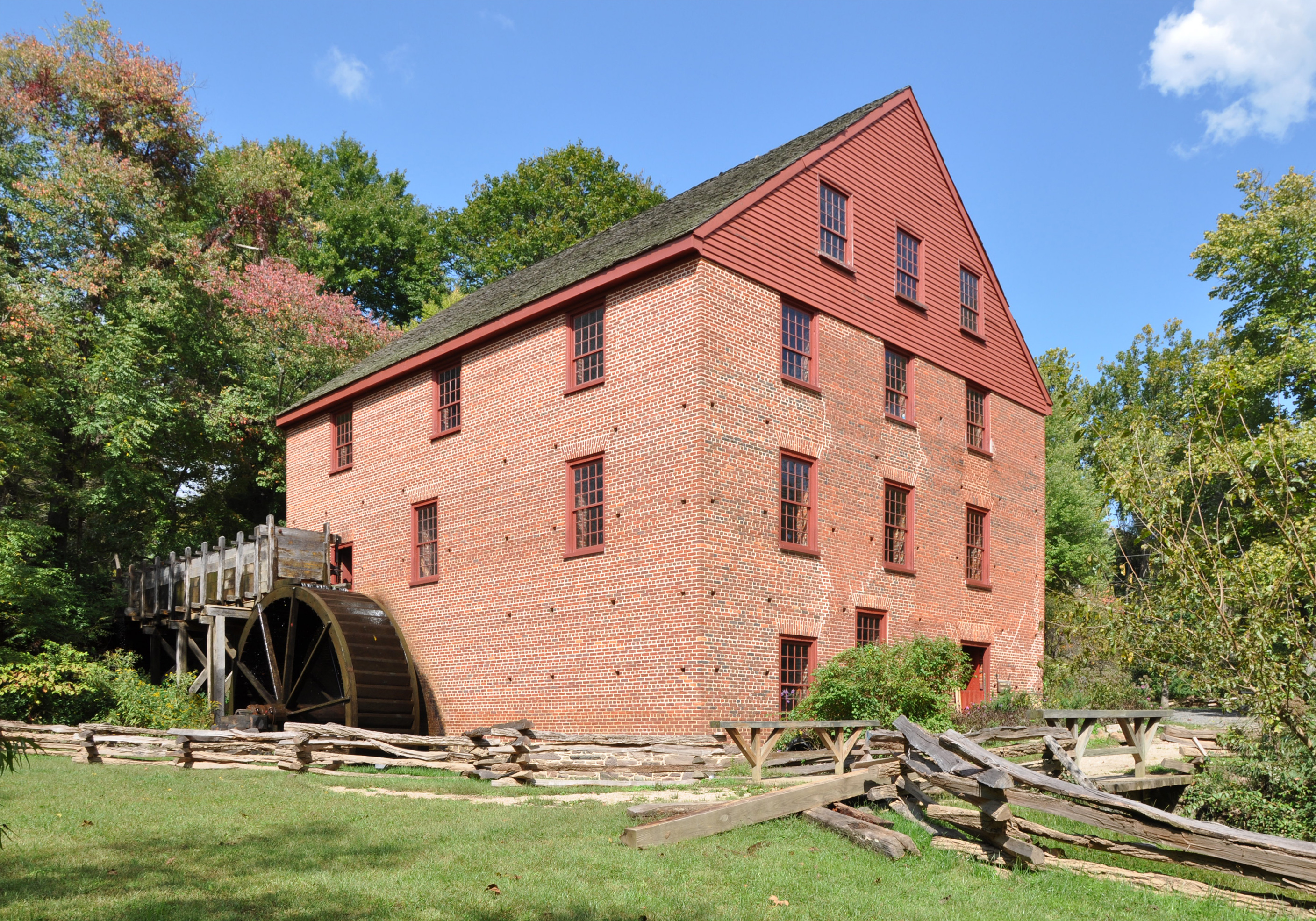
[1]Added to NRHP: August 16, 1977 Colvin Run Mill is in Great Falls, Virginia. Built c. 1811, Colvin Run Mill is the sole surviving operational 19th-century water-powered mill in the Washington, D.C. metropolitan area, and its restored mechanism is a nationally significant example of automated technologies pioneered in milling and later adopted across American industry.[2] Down the gravel path of the park is the miller's house, home to the families who ran the mill. In 1883, Addison Millard moved his family here when he bought the old mill. Addison, his wife Emma, and some of their 20 children lived there. When Addison died, the family stayed and operated the mill until 1934. [3]
In the mid-1930s the mill was abandoned, and highway development caused the mill to be cut off from any near-by water source. The mill was later acquired by the Fairfax County Park Authority,repaired, and made open to the public.[4]
References
- ^ "National Register Information System". National Register of Historic Places. National Park Service. 2008-04-15. http://nrhp.focus.nps.gov/natreg/docs/All_Data.html.
- ^ "Colvin Run Mill - History". The American Society of Mechanical Engineers (ASME). May 10, 2001. http://files.asme.org/ASMEORG/Communities/History/Landmarks/5516.pdf.
- ^ "Colvin Run Mill - History". May 14, 2008. http://www.fairfaxcounty.gov/parks/crm/history.htm.
- ^ Netherton, Ross D. Colvin Run Mill. Fairfax,VA: Fairfax County Office of Comprehensive Planning, 1985
External links
- Official website
- Colvin Run Mill Park and Village
- Colvin Run Mill YouTube video. Retrieved September 07, 2009
U.S. National Register of Historic Places Topics Lists by states Alabama • Alaska • Arizona • Arkansas • California • Colorado • Connecticut • Delaware • Florida • Georgia • Hawaii • Idaho • Illinois • Indiana • Iowa • Kansas • Kentucky • Louisiana • Maine • Maryland • Massachusetts • Michigan • Minnesota • Mississippi • Missouri • Montana • Nebraska • Nevada • New Hampshire • New Jersey • New Mexico • New York • North Carolina • North Dakota • Ohio • Oklahoma • Oregon • Pennsylvania • Rhode Island • South Carolina • South Dakota • Tennessee • Texas • Utah • Vermont • Virginia • Washington • West Virginia • Wisconsin • WyomingLists by territories Lists by associated states Other  Category:National Register of Historic Places •
  Portal:National Register of Historic PlacesCategories:
- National Register of Historic Places in Virginia
- Buildings and structures completed in 1811
- Virginia Municipal and County Parks
- Museums in Fairfax County, Virginia
- Mill museums in Virginia
- Parks in Fairfax County, Virginia
- Fairfax County, Virginia geography stubs
- Virginia building and structure stubs
- Virginia Registered Historic Place stubs

Wikimedia Foundation. 2010.