- Derrygonnelly
-
Coordinates: 54°24′04″N 7°48′11″W / 54.401°N 7.803°W
Derrygonnelly Scots: Derrygonlie[1] Irish: Doire Ó gConaíle 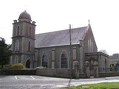
Derrygonnelly Catholic church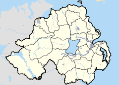
 Derrygonnelly
Derrygonnelly shown within Northern IrelandPopulation 594 (2001 Census) District Fermanagh County County Fermanagh Country Northern Ireland Sovereign state United Kingdom Postcode district BT93 Dialling code 028 EU Parliament Northern Ireland UK Parliament Fermanagh and South Tyrone NI Assembly Fermanagh and South Tyrone List of places: UK • Northern Ireland • Fermanagh Derrygonnelly (from Irish: Doire Ó gConaíle, meaning "O'Connelly's oak grove")[2][3] is a small village and townland in County Fermanagh, Northern Ireland. Near Lower Lough Erne, the village was home to 594 people (at the 2001 Census) and dates to the Plantation era.[3]
The village has a long history of Irish traditional music and each year in early October there is a celebration of local talent in memory of the late musicians Eddie Duffy and Mick Hoy.[3] Musicians come from all over Ireland and from further afield to enjoy this festival which bases itself in any of Derrygonnelly's four pubs.
Contents
History
Derrygonnelly was founded by General Archdale as a Plantation town. The area hosted fairs from the late 18th century but the village itself only really developed as late as 1812 when the long, flat main street was built along the Sillees River.[3] The main road to Enniskillen was known as the Famine Road as it was made during the 1846 famine as a relief scheme.[3]
Places of interest
The old creamery in Derrygonnelly has been converted into a residential environmental education centre, Tir Navar, run by the Field Studies Council.[3][4]
Approximately one mile to the northwest of the village are the ruins of Carrick Church; built by Gilbert O'Flanagan in 1483 "In Honour of God and Mary". The church's graveyard was used by the locals until around 1930. Also just north of the village is a small ruined church that combines medieval and Renaissance features, built in 1627 by Sir John Dunbar. His coat of arms is located over the doorway. Other 17th century ruins in the nearby area include Monea Castle and Tully Castle, the latter having been sacked and burned by Rory Maguire on Christmas Day during the 1641 rebellion. As well as Lower Lough Erne to the north, Derrygonnelly is surrounded by small lakes and is split by the Sillees River, which is popular with canoeists.
4 miles (6.4 km) outside the village towards Garrison are the Correl Glens and Lough Navar Forest Drive. The Forest Drive is a 7-mile (11 km) walk through Lough Navar Forest incorporating a beautiful viewpoint at the top looking over Lower Lough Erne, as far as the Donegal coast to the west and the Sperrin Mountains in County Tyrone to the north and east. The drive is also open to motor vehicles. On the opposite side of the road lies Correl Glens, which features another popular walking route, with some small waterfalls near the entrance.
Education
Derrygonnelly has two primary schools;
- St Patrick's Primary School
- Derrygonnelly Controlled Primary School
Gaelic sports
Main article: Derrygonnelly HarpsThe local Gaelic football team are the Derrygonnelly Harps (Doire Ó gConaile na Cláirsigh) who play on their home ground of Canon Maguire Park. The club was founded in 1924. The team has enjoyed much underage success in recent years, and at senior level have gained three New York Gold Cups (the County Championship), one in 1995, 2004 and the most recent in 2009. There are teams fielded at every level of mens' and ladies' football. Currently the club is undergoing even more redevelopments with the improvement of facilities.
2001 Census
Derrygonnelly is classified as a small village or hamlet by the NI Statistics and Research Agency (NISRA) (i.e. with a population of between 500 and 1,000 people). On Census day (29 April 2001) there were 594 people living in Derrygonnelly. Of these:
- 23.6% were aged under 16 and 19.7% were aged 60 and over
- 50.3% of the population were male and 49.7% were female
- 77.4% were from a Catholic background and 20.1% were from a Protestant background
- 4.0% of people aged 16–74 were unemployed.
For more details see: NI Neighbourhood Information Service
References
- ^ White Island and Inishmacsaint (Ulster-Scots translation) Department of the Environment.
- ^ Placenames Database of Ireland
- ^ a b c d e f "Your Area: Derrygonnelly". Culture Northern Ireland. http://www.culturenorthernireland.org/YourArea.aspx?location=540. Retrieved 2009-11-30.[dead link]
- ^ "Tir Navar". Northern Ireland Tourist Board. http://www.discovernorthernireland.com/Tir-Navar-Derrygonnelly-Enniskillen-P4069. Retrieved 2009-11-30.
External links
Categories:- Villages in County Fermanagh
- Townlands in County Fermanagh

Wikimedia Foundation. 2010.