- Holywell, County Fermanagh
Infobox Irish Place|thumb|left|name = Holywell
irish = Dabhach Phádraig
scots =
map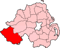
pin coords =
north coord = | west coord =
province =Ulster
county =County Fermanagh
NI district =Fermanagh
UK constituency = Fermanagh and South Tyrone
stdcode = 028, +44 28
posttown =
postcode =
population =
census yr = 2001
web = www.fermanagh.gov.ukHolywell (Irish: "Dabhach Phádraig") is a small
village inCounty Fermanagh ,Northern Ireland , nearBelcoo . It had a population (with Belcoo) of 486 in the 2001 Census. It is in theFermanagh District Council area.Places of interest
*Templerushin Church at Holywell has a little window in the wall of the church known as the leper window, where those with this illness could look in to observe Mass but could not attend.
*Near to the church there is a large spring, this is the Holy well after which the village has been named. This well, like many other religious sites inIreland , is linked withSaint Patrick . There are two streams exiting the well, each flowing in a different direction. This water is reputed to be the coldest inIreland . TheLegion of Mary see to the upkeep of the Holywell, a place of pilgrimage for many local people who perform penitential stations during the old period of Lughnasa from the last weekend in July untilAugust 15 .References
* [http://www.ninis.nisra.gov.uk/ NI Neighbourhood Information Service]
* [http://www.fermanagh.org.uk/genealogy/history/monast.htm Fermanagh Gold]
* [http://www.culturenorthernireland.org/town_Home.aspx?co=5&to=106&ca=0&sca=0&navID=1 Culture Northern Ireland]
* [http://www.clogherhistory.ie/Dabhach-Phadraig Holy Well page of Clogher Historical Society/Cumann Seanchais Chlochair website - includes current pilgrimage and contact details]See also
*
List of villages in Northern Ireland
*List of towns in Northern Ireland
Wikimedia Foundation. 2010.