- Aghadrumsee
Infobox Irish Place|thumb|left|name = Aghadrumsee
irish = Átha Droim Sí
scots =
map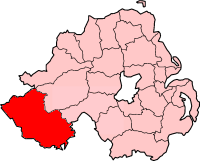
pin coords =
north coord = | west coord =
province =Ulster
county =County Fermanagh
NI district =Fermanagh
UK constituency = Fermanagh and South Tyrone
stdcode = 028, +44 28
posttown =
postcode =
population =
census yr = 2001
web = www.fermanagh.gov.ukAghadrumsee ( _ga. Átha Droim Sí) is a small village in the South East Region of
County Fermanagh ,Northern Ireland . It comes under theChurch of Ireland andRoman Catholic dioceses ofClogher . The parish of Aghadrumsee straddles the border town ofClones ,County Monaghan in the Republic of Ireland. Historically the town of Clones has had a significant influence on this rural community mainly due to the railway which used to go through it.There are three primary schools, two Catholic - Cornagague and Corranny and one Controlled - Aughadrumsee. All are sited in rural locations within three miles of each other. The community is served by a number of Churches, the two main ones being St. Mark's Church of Ireland and St. Macartan's Roman Catholic Chapel. There are a small number of gospel halls in the area.
There is an Orange Hall at Aghadrumsee and another one at nearby Dromaddy. The area also has a Gaelic Athletic Club called St Macartans Aghadrumsee which provides sport for both men and women. The local badminton team has a good reputation for skillful players.
There are only two grocery shops in the area and a solitary local public house. The area is in the political ward of Erne East and is represented by politicians from each of the four local parties,
Democratic Unionist Party ,Ulster Unionist Party ,Sinn Féin and theSocial Democratic and Labour Party .The name "Aghadrumsee" is derived from the Gaelic "Agha" (field) "Droim" (hillock) "Sidhe" (fairy) and means "field of the fairy hillock."
Wikimedia Foundation. 2010.