- Millis, Massachusetts
-
Millis, Massachusetts — Town — Veterans Memorial Building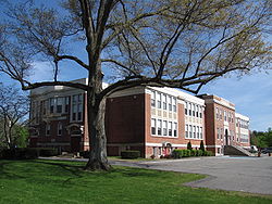

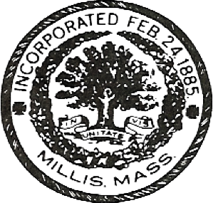
SealMotto: In unitate vis (Latin "In the Unity of (the) Force") Location in Norfolk County in Massachusetts
Coordinates: 42°10′03″N 71°21′30″W / 42.1675°N 71.35833°WCoordinates: 42°10′03″N 71°21′30″W / 42.1675°N 71.35833°W Country United States State Massachusetts County Norfolk Settled 1657 Incorporated 1885 Government - Type Open town meeting Area - Total 12.3 sq mi (31.8 km2) - Land 12.2 sq mi (31.5 km2) - Water 0.1 sq mi (0.3 km2) Elevation 163 ft (50 m) Population (2010) - Total 7,891 - Density 646.8/sq mi (250.5/km2) Time zone Eastern (UTC-5) - Summer (DST) Eastern (UTC-4) ZIP code 02054 Area code(s) 508 / 774 FIPS code 25-41515 GNIS feature ID 0618324 Website http://www.millis.org/ Millis is a town in Norfolk County in the U.S. state of Massachusetts. It is a small town with a population of 7,891 according to the 2010 census. The town is approximately 19 miles (31 km) southwest of downtown Boston and is bordered by Norfolk, Sherborn, Holliston, Medfield, and Medway. Massachusetts state routes 109 and 115 run through Millis.
For geographic and demographic information on the village of Millis-Clicquot, see Millis-Clicquot, Massachusetts.
Contents
History
Millis was first settled in 1657 and was officially incorporated in 1885. Millis was originally part of Dedham, Massachusetts until that town granted the lands of Millis, and other present day surrounding towns, to Medfield in 1651. In 1713, pioneers of Medfield applied for a grant to create a new town and, when approved, named this new land Medway. This new town consisted of West Medway (the present day town) and East Medway (present day Millis). Lansing Millis, the founder of the town, successfully incorporated Millis into the Commonwealth of Massachusetts on February 24, 1885.
Lansing Millis was successful in turning the small town of Millis into an important area of Massachusetts. Lansing Millis, who was widely known as a connoisseur in railroads and trains, built up a strong rail system in Millis. This was arguably his most important accomplishment, as the rail system is regarded as the most significant factor in its independence from Medway. In addition, the railroad system was a major factor in the early promotion of economic growth in the town and the integration of Millis to the larger cities of Dedham, Boston, and Cambridge, Massachusetts. Currently, this old railroad that used to begin in Medway is known as the Bay Colony Railroad. The Medway tracks have since been dismantled, making Millis the railroad's western terminus. The railroad is now mostly defunct, but several miles of the Bay Colony tracks in Millis are privately owned and operated by the GAF industrial enterprise located in the Clicquot neighborhood of Millis. The Bay Colony Railroad merges with the present day MBTA Commuter Rail in Needham.
Aside from the tremendous contribution of the rail system to Millis' integration with the major Massachusetts cities, another important moment in the town's history was the construction of the Hartford and Dedham Turnpike, known today as Massachusetts Route 109. The road was constructed in 1806 and officially accepted by the town of Millis in 1896. The Hartford and Dedham Turnpike connected Millis, Medway, Medfield, and several other towns directly to Dedham and Boston. Today, Route 109 still serves as a major road connecting Metrowest Boston communities to the city of Boston.
Millis is the home of the nationally famous "Millis Lights". The "Millis Lights" are a display of Christmas decorations and lights on the 40-acre (160,000 m2) Causeway Street estate of Kevin Meehan, the owner of several car dealerships. In 2004, Al Roker traveled to Millis for a segment centered around the "Millis Lights". After the publicity of the The Today Show, an estimated 7,000 cars traveled to the "Millis Lights" daily during the Christmas season.[1]
Industrial history
The industrial history of Millis is long and varied, beginning with the water power of a small establishment named Hinsdell's mill. Soon, Millis grew from a small new town with a mill to a successful industrial society. Numerous industries opened up in the town and stimulated employment and growth. Some of these industries include the Holbrook factories, which included a bell foundry, organ manufactory, and organ pipe manufactory, Clicquot Club, and Herman Shoe Company; the latter two being the most notable industries in the town's history.
Today the prominent employers in the town are Tresca Brothers Sand & Gravel, Lucas Manufacturing Co., Inc. and formally the GAF roofing plant. Millis is also home to a thriving automobile recycling industry located in the western, industrial section of town.
Herman Shoe Company
The Herman Shoe Company was an extremely important industry in town. The Herman Shoe Company, a result of several private buyouts, produced large amounts of material, specifically boots and other equipment, during the Spanish-American War. In addition, it produced most of the boots worn by the troops during World War II.
The company is now out of business and the former factory stands empty in the Clicquot neighborhood, next to the former Clicquot Club factory. It has recently been bought by a private entrepreneur who renovated the building, but there is no news on what will become of it.
Clicquot Club
Clicquot Club was started by Henry Millis, using funds from his father and founder of Millis, Lansing Millis. The company, which distributed the first brand of ginger ale in the United States for about eighty years, is located on Main Street and is the namesake for the village of Clicquot in Millis. The ginger ale produced by Clicquot Club was made using local Millis ginger[citation needed]. Later, the company produced several different sodas and was the first company in the nation to can drinks. Clicquot Club owned more than 100 factories throughout the United States and sold its beverages internationally. As sales declined in the 1960s, however, the company went bankrupt and was bought by the Cott company, which in turn was acquired by Canada Dry.
Causeway Street and the Brickyards
An area of land around Causeway Street, although now a rural street in the west of town, was once a huge industrial hub for the early town of Millis. This area of Causeway Street was used for clay excavation for the manufacture of bricks, as well as sand excavation. The clay excavations were turned into bricks that built many large estates and buildings in the immediate area and beyond. The remnants of clay pits today look like small ponds. In fact, one of the clay pits is so large that it is now a body of water named Heather’s Pond. These abandoned pits are home to many species of wildlife and are protected along with the Great Black Swamp. Historically, the sand from the pits was used to fill in the most recent runway at Logan International Airport. Today, the remnants of old sand pits lay vacant.
The several large brickyards around Causeway Street were owned by a few wealthy families. One of these estates, the Clark Family estate, was later the home to former Massachusetts Governor and United States Secretary of State Christian Herter.
Notable sites
One of the most important sites in Millis is Richardson’s Tavern, which was built around 1720. This tavern accommodated George Washington for lunch on his way to Cambridge in 1775. It is rumored that Nathan Hale and the Marquis de Lafayette also stopped at the tavern to dine.
Millis’ cemetery, called Prospect Hill Cemetery, is home to the grave of Christian Herter, the United States Secretary of State under President Dwight D. Eisenhower. Secretary Herter lived on a large farm on Causeway Street in Millis and, it is rumored, when summoned to Washington, D.C., he left his farm directly by helicopter to Logan International Airport.
King Philip's War
The history of Millis is closely tied with King Philip's War of 1675 to 1676. On February 21, 1676, Native Americans killed 17 Medfield citizens and destroyed half of the town (32 houses, two mills, and many barns). Immediately after this attack, the Native Americans under King Philip (Metacom) fled to Millis where they held a grand feast. This spot is marked by “The King Phillip Trees”, which are two hundred year old trees protected by the Millis Historical Society. The next day, on February 22, the Native American forces led an offensive against the Fayerbanke Palisades at Boggestowe Farms, which are in present-day Millis. This attack was repulsed, as well as a second attack, which occurred on May 6.
Geography
There are many areas of town-administered land, which helps to protect the environment and limit development. In addition, Millis has several wells and is home to various large farms.
The Charles River runs through Millis and the town has other smaller streams and brooks; most notably Bogastowe Brook. Boggestowe Brook, named after the Indian tribe formerly inhabiting the area, rises in East Holliston and runs through Millis, emptying in Millis’ South End Pond.
Millis is also home to the Great Black Swamp. This swamp, covering hundreds of acres, is a very important characteristic of Millis. This swamp geographically divides Millis from its neighboring town Medway, and is a significant factor in the separation of the two towns in 1885.
According to the United States Census Bureau, the town has a total area of 12.3 square miles (32 km2). Of this, 12.2 square miles (32 km2) is land and 0.1 square miles (0.26 km2) (0.90%) is water.
Education
The Millis educational system is served by Clyde F. Brown Elementary School and Millis Middle/High School. The Millis public school system is the smallest public school system in the state of Massachusetts. In 2005, the graduating class of Millis High School was 73 students, and was one of the larger classes of the past few years. However, it was not as large as the 2003 graduating class with 79 students. The current class of 2008 contains approximately 60 students.
In 1999, Millis Middle/High School underwent a complete renovation, costing millions of dollars.
The Millis Public Library is the only library in the town and is part of the Minuteman Library Network.
In 2006 Millis ranked first in the state, alongside the Boston Latin School, for English MCAS scores. Millis also came in tenth in the state in the Math portion of the MCAS in the same year.
In 2007 Millis was awarded the Blue Ribbon School Of Excellence award by the Federal Government under the No Child Left Behind Act. In addition, Millis High School has been awarded with Silver Medal status is US News and World Report's [1] online ranking of U.S. highschools.
In 2010, Millis earned Silver Medal status as one of America's Best High Schools in US News and World Report's latest ranking of public high schools. The magazine editors analyzed 18,743 high schools in the United States and ranked Millis High School in the top 3% [2]
Demographics
Historical populations Year Pop. ±% 1890 786 — 1900 1,053 +34.0% 1910 1,399 +32.9% 1920 1,485 +6.1% 1930 1,738 +17.0% 1940 2,278 +31.1% 1950 2,551 +12.0% 1960 4,374 +71.5% 1970 5,686 +30.0% 1980 6,908 +21.5% 1990 7,613 +10.2% 2000 7,902 +3.8% 2001* 7,972 +0.9% 2002* 7,973 +0.0% 2003* 7,964 −0.1% 2004* 7,933 −0.4% 2005* 7,901 −0.4% 2006* 7,929 +0.4% 2007* 7,945 +0.2% 2008* 8,009 +0.8% 2009* 8,029 +0.2% 2010 7,891 −1.7% * = population estimate. Source: United States Census records and Population Estimates Program data.[3][4][5][6][7][8][9] As of the census[10] of 2009, there were 8,029 people, 3,004 households, and 2,162 families residing in the town. The population density was 650.0 people per square mile (250.9/km²). There were 3,066 housing units at an average density of 252.2 per square mile (97.4/km²). The racial makeup of the town was 96.94% White, 0.71% African American, 0.14% Native American, 1.14% Asian, 0.24% from other races, and 0.84% from two or more races. Hispanic or Latino of any race were 0.94% of the population. The ethnic make-up of the town is diverse. The four largest ethnicities reported in the town are 29% Irish, 16% Italian, 11% English, and 7% German. There are many other smaller percentages of several ethnic groups, such as Arab, French, Scottish, Greek, Russian, and Bulgarian, among others.[2]
There were 3,004 households out of which 37.3% had children under the age of 18 living with them, 60.3% were married couples living together, 9.3% had a female householder with no husband present, and 28.0% were non-families. 22.8% of all households were made up of individuals and 7.1% had someone living alone who was 65 years of age or older. The average household size was 2.62 and the average family size was 3.12.
In the town the population was spread out with 26.9% under the age of 18, 5.0% from 18 to 24, 33.6% from 25 to 44, 25.1% from 45 to 64, and 9.4% who were 65 years of age or older. The median age was 37 years. For every 100 females there were 93.8 males. For every 100 females age 18 and over, there were 90.1 males.
The median income for a household in the town was $62,806, and the median income for a family was $72,171. Males had a median income of $51,250 versus $35,556 for females. The per capita income for the town was $27,957. About 3.0% of families and 2.9% of the population were below the poverty line, including 2.8% of those under age 18 and 2.3% of those age 65 or over.
Notable residents
- Christian Herter, U.S. Secretary of State under Dwight D. Eisenhower. It is recorded that one day a rural letter carrier was stopped by the FBI because President Eisenhower was supposedly visiting Christian Herter and strict security measures were in place.
- John Kerry, U.S. Senator. Senator Kerry lived in Millis until the age of 7, when the family moved to Washington, D.C. On Sunday, July 4, 2004, the CBS show CBS Sunday Morning aired a segment on the upcoming Presidential Election between George W. Bush and John Kerry. In this segment, Millis was featured as John Kerry's hometown. Jeffery Hardin, a Millis Selectman, was interviewed.[3]
- Misha Defonseca (Monique De Wael), author. Misha claimed to be a Holocaust survivor. She is famous for her book Misha: A Memoire of the Holocaust Years which recently she admitted was a hoax.
References
- ^ http://www.usnews.com/listings/high-schools/massachusetts/millis_high_school
- ^ http://www.usnews.com/listings/high-schools/massachusetts/millis_high_school
- ^ "TOTAL POPULATION (P1), 2010 Census Summary File 1, All County Subdivisions within Massachusetts". United States Census Bureau. http://factfinder2.census.gov/bkmk/table/1.0/en/DEC/10_SF1/P1/0400000US25.06000. Retrieved September 13, 2011.
- ^ "Massachusetts by Place and County Subdivision - GCT-T1. Population Estimates". United States Census Bureau. http://factfinder.census.gov/servlet/GCTTable?_bm=y&-geo_id=04000US25&-_box_head_nbr=GCT-T1&-ds_name=PEP_2009_EST&-_lang=en&-format=ST-9&-_sse=on. Retrieved July 12, 2011.
- ^ "1990 Census of Population, General Population Characteristics: Massachusetts". US Census Bureau. December 1990. Table 76: General Characteristics of Persons, Households, and Families: 1990. 1990 CP-1-23. http://www.census.gov/prod/cen1990/cp1/cp-1-23.pdf. Retrieved July 12, 2011.
- ^ "1980 Census of the Population, Number of Inhabitants: Massachusetts". US Census Bureau. December 1981. Table 4. Populations of County Subdivisions: 1960 to 1980. PC80-1-A23. http://www2.census.gov/prod2/decennial/documents/1980a_maABC-01.pdf. Retrieved July 12, 2011.
- ^ "1950 Census of Population". Bureau of the Census. 1952. Section 6, Pages 21-10 and 21-11, Massachusetts Table 6. Population of Counties by Minor Civil Divisions: 1930 to 1950. http://www2.census.gov/prod2/decennial/documents/23761117v1ch06.pdf. Retrieved July 12, 2011.
- ^ "1920 Census of Population". Bureau of the Census. Number of Inhabitants, by Counties and Minor Civil Divisions. Pages 21-5 through 21-7. Massachusetts Table 2. Population of Counties by Minor Civil Divisions: 1920, 1910, and 1920. http://www2.census.gov/prod2/decennial/documents/41084506no553ch2.pdf. Retrieved July 12, 2011.
- ^ "1890 Census of the Population". Department of the Interior, Census Office. Pages 179 through 182. Massachusetts Table 5. Population of States and Territories by Minor Civil Divisions: 1880 and 1890. http://www2.census.gov/prod2/decennial/documents/41084506no553ch2.pdf. Retrieved July 12, 2011.
- ^ "American FactFinder". United States Census Bureau. http://factfinder.census.gov. Retrieved 2008-01-31.
External links
Municipalities and communities of Norfolk County, Massachusetts County seat: Dedham Cities 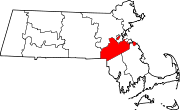
Towns CDPs Bellingham | Dover | Foxborough | Medfield | Millis-Clicquot | Sharon | Walpole
Other
villageCategories:- Towns in Norfolk County, Massachusetts


Wikimedia Foundation. 2010.