- Dowgate
-
Coordinates: 51°30′40″N 0°05′20″W / 51.511°N 0.089°W
Ward of Dowgate
 Ward of Dowgate shown within Greater London
OS grid reference TQ319812 Sui generis City of London Administrative area Greater London Region London Country England Sovereign state United Kingdom Post town LONDON Postcode district EC4 Dialling code 020 Police City of London Fire London Ambulance London EU Parliament London UK Parliament Cities of London and Westminster London Assembly City and East List of places: UK • England • London Dowgate is a small ward of the City of London. The ward is bounded by Swan Lane, the River Thames, Cousin Lane and Cannon Street. Dowgate is where the Walbrook watercourse entered the Thames.
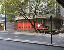
 Dowgate fire station on Upper Thames Street — the only modern-day fire station in the City (operated by the London Fire Brigade)
Livery companies quartered in the ward, include the Dyers, Innholders, Skinners and Tallow Chandlers situated in Dowgate Hill. There is one church, St Michael Paternoster,[1] also housing The Mission to Seafarers. The ward also contains Cannon Street railway station, which is on the site of the medieval Steelyard.
Contents
Politics
Dowgate is one of 25 wards in the City of London, each electing an Alderman, to the Court of Aldermen and Commoners (the City equivalent of a Councillor) to the Court of Common Council of the City of London Corporation. Only electors who are Freeman of the City of London are eligible to stand.
References
- ^ Betjeman described it as
A round colonnaded temple with round urns on it, a middle stage with curving corbels, more urns, round turret supporting a vane.
Bibliography
The City of London Churches Betjeman,J: Andover, Pitkin,1972 ISBN 0853721122
External links
- Corporation of London - present day map of Dowgate ward
- Vintry and Dowgate Wards Club
- City of London police
- Alison Gowman, Alderman of Dowgate Ward
- Map of Early Modern London: Downgate Ward - Historical Map and Encyclopedia of Shakespeare's London (Scholarly)
City of London Wards Aldersgate · Aldgate · Bassishaw · Billingsgate · Bishopsgate · Bread Street · Bridge · Broad Street · Candlewick · Castle Baynard · Cheap · Coleman Street · Cordwainer · Cornhill · Cripplegate · Dowgate · Farringdon Within · Farringdon Without · Langbourn · Lime Street · Portsoken · Queenhithe · Tower · Vintry · Walbrook
Enclaves Localities Attractions Bank of England Museum · Barbican Centre · Clockmakers' Museum · Dr. Johnson's House · Guildhall Art Gallery · London Mithraeum · London Stone · Mansion House · The Monument · Museum of London · Old Bailey · St. Paul's Cathedral · Smithfield MarketCivil parishes Bridges Tube and rail stations Gates and Bars of the City of London Former gates of London Wall and City bars
Temple Bar · Ludgate† · Holborn Bar · Newgate† · Aldersgate† · Cripplegate† · Moorgate · Bishopsgate† Bars · Aldgate† · (Tower) Posterngate
Listed clockwise from the West
Water-gates: Billingsgate and Dowgate
Bridge-gates: Great Stone Gateway and New Stone Gate
†The six Roman gates Categories:
- Wards of the City of London
- London geography stubs
- ^ Betjeman described it as
Wikimedia Foundation. 2010.


