- Cheap (ward)
-
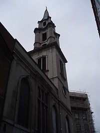 St Vedast, a familiar Cheap landmark
Coordinates: 51°30′53″N 0°05′38″W / 51.5148°N 0.094°W
Ward of Cheap 
 Ward of Cheap
Ward of Cheap shown within Greater LondonOS grid reference TQ321812 Sui generis City of London Administrative area Greater London Region London Country England Sovereign state United Kingdom Post town LONDON Postcode district EC1, EC4 Dialling code 020 Police City of London Fire London Ambulance London EU Parliament London UK Parliament Cities of London and Westminster London Assembly City and East List of places: UK • England • London Cheap (meaning market[1]) is a small ward of the City of London. It stretches west to east from King End Street, the border with Farringdon Within to Old Jewry, which adjoins Walbrook and north to south from Gresham Street, the border with Aldersgate and Bassishaw to Cheapside, the boundary with Cordwainer.
The following roads run north to south across the ward: St Martin’s Le Grand,[2] Foster Lane, Gutter Lane, Wood Street and King Street. Within its boundaries are two Anglican churches, St Vedast alias Foster[3] and St Lawrence Jewry[4], and several halls, including Goldsmiths Hall, Mercers Hall, Sadlers Hall and Wax Chandlers Hall.[5] A third church, St Mildred, Poultry, was demolished in 1872.
A small part of the Guildhall buildings lies within the ward's boundaries — the main entrance and main hall itself — with the remainder being in the ward of Bassishaw. Also within the boundaries is the Mayor's and City of London Court and the southern end of Basinghall Street.[6]
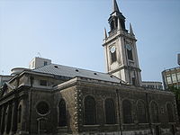 St Lawrence Jewry in Gresham Street
Politics
Cheap is one of 25 wards in the City of London, each electing an Alderman, to the Court of Aldermen and Commoners (the City equivalent of a Councillor) to the Court of Common Council of the City of London Corporation. Only electors who are Freeman of the City of London are eligible to stand.
References
- ^ cheap, n., I.2.b., Oxford English Dictionary, Second Edition, 1989, Oxford University Press.
- ^ http://www.moveandstay.com/offices_description.asp?id=1320 Details of junction
- ^ Parish Web Site
- ^ More details
- ^ Police overview
- ^ http://213.86.34.248/NR/rdonlyres/5115C3A2-5389-4865-9AA6-4D713BFF5C7A/0/cheap.jpg
External links
- Map of Early Modern London: Cheap Ward - Historical Map and Encyclopedia of Shakespeare's London (Scholarly)
- Corporation of London Cheap ward boundaries
City of London Wards Aldersgate · Aldgate · Bassishaw · Billingsgate · Bishopsgate · Bread Street · Bridge · Broad Street · Candlewick · Castle Baynard · Cheap · Coleman Street · Cordwainer · Cornhill · Cripplegate · Dowgate · Farringdon Within · Farringdon Without · Langbourn · Lime Street · Portsoken · Queenhithe · Tower · Vintry · Walbrook
Enclaves Localities Attractions Bank of England Museum · Barbican Centre · Clockmakers' Museum · Dr. Johnson's House · Guildhall Art Gallery · London Mithraeum · London Stone · Mansion House · The Monument · Museum of London · Old Bailey · St. Paul's Cathedral · Smithfield MarketCivil parishes Bridges Tube and rail stations  Category ·
  CommonsCategories:
- Wards of the City of London
- London geography stubs


Wikimedia Foundation. 2010.