- Cripplegate
-
Coordinates: 51°31′08″N 0°05′38″W / 51.519°N 0.094°W
Ward of Cripplegate 
 Ward of Cripplegate
Ward of Cripplegate shown within Greater LondonOS grid reference TQ327811 Sui generis City of London Administrative area Greater London Region London Country England Sovereign state United Kingdom Post town LONDON Postcode district EC3 Dialling code 020 Police City of London Fire London Ambulance London EU Parliament London UK Parliament Cities of London and Westminster London Assembly City and East List of places: UK • England • London Cripplegate was a city gate in the London Wall and a name for the region of the City of London outside the gate. The area was almost entirely destroyed by bombing in World War II and today is the site of the Barbican Estate and Barbican Centre. The name is preserved in the church of St Giles-without-Cripplegate, and in the Cripplegate ward of the City, while a street named Cripplegate lies slightly to the north of the site of the Wall.
The ward straddles the (now former) line of the Wall and the old gate and is often (even today[1]) divided into "Within" and "Without" parts, with a Beadle and a Deputy (Alderman) appointed for each part. Since the 1994 (City) and 2003 (ward) boundary changes, most of the ward is Without, with the ward of Bassishaw having expanded considerably into the Within area.
Contents
History
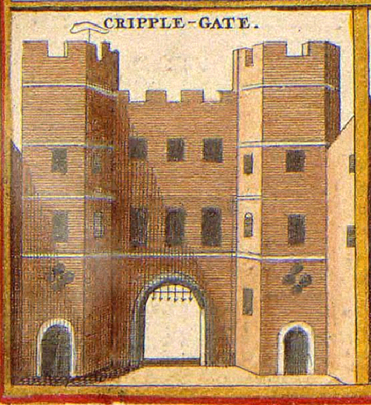
 An old illustration of the gate circa 1650
Cripplegate stood at the northern end of what is now Wood Street at the junction of St Alphage Gardens. It was already in place when the city wall was built, as it was the northern gate of a Roman fort which was built in 120 AD. The northern and western walls formed part of the new wall, although these defences were completely rebuilt in early medieval times. Like a number of its sister gates, it was used as a prison for part of its life, being leased for accommodation at other times.
The gate gave access to a substantial medieval suburb and to the village of Islington. Extra defensive works on the northern site outside the gate gave rise to the name 'barbican' (or outer fortification of the City), which was then taken as the name for the post World War II rebuilding of the area. It originally only led into the fort and became a gate into the City when the fort was demolished.
In 1244 it was rebuilt by the Brewers Company, and then rebuilt again in 1491, had alterations in 1663 and when it was finally demolished in 1760 so that the street could be widened. The materials were sold to a local carpenter for £91.
In 1555, Sir John Gresham endowed the new Gresham's School in Norfolk with three tenements in the parish of St Giles Without, Cripplegate, including 'The White Hind' and 'The Peacock'.[2]
During World War II the Cripplegate area was virtually demolished and by 1951 the resident population of the City stood at only 5,324 of whom 48 lived in Cripplegate. Discussions began in 1952 about the future of the site, and the decision to build new residential properties was taken by the Court of Common Council on 19 September 1957. The area was reopened as the Barbican Estate in 1969. Cripplegate is today the most populous of the four residential wards of the City.
Name
The name of the gate has obscure origins. It could be that it is so-called because of the cripples who used to beg there, although this is unsubstantiated. The body of St Edmund the Martyr was said to have been carried through it in 1010 on its way from Bury St Edmunds to St Gregory's church to save it from the Danes. Lydgate, a monk of Bury, claimed that the body cured many lame peasants as it passed through the gate. Alternatively 'Cripplegate' could be from the Anglo-Saxon term crepel, meaning a covered way or underground passage. The gate is mentioned in the fourth law code of Ethelred the Unready and a charter of William the Conqueror of 1068. In both these documents the spelling used is 'Crepelgate' ('Saxon London', by Alan Vince, 1990, p43).
Politics
Cripplegate is one of twenty-five wards in the City of London, each electing an alderman, to the Court of Aldermen and commoners (the City equivalent of a councillor) to the Court of Common Council of the City of London Corporation. Only electors who are Freemen of the City of London are eligible to stand.
References in Fiction
The second wedding in Four Weddings and a Funeral takes place in the fictional church of St Mary-in-the-Fields, Cripplegate, EC2 (sic).
It was filmed in the Royal Naval College Chapel in Greenwich.[3]
See also
References
- ^ Cripplegate Ward News - note use of "Within" and "Without" on page 4
- ^ Herbert, William, The History of the Twelve Great Livery Companies of London (London, Wm Herbert, 1836) pp. 80-81 at books.google.co.uk
- ^ http://www.movie-locations.com/movies/f/4wandf.html
- Old and New London and A New History of London — two historical sources on the ward from British History Online
- Map of Early Modern London: Cripplegate Ward - Historical Map and Encyclopedia of Shakespeare's London(Scholarly)
External links
- Cripplegate Ward The Official Ward Website
- City of London Corporation Map of Cripplegate ward (2003 —)
City of London Wards Aldersgate · Aldgate · Bassishaw · Billingsgate · Bishopsgate · Bread Street · Bridge · Broad Street · Candlewick · Castle Baynard · Cheap · Coleman Street · Cordwainer · Cornhill · Cripplegate · Dowgate · Farringdon Within · Farringdon Without · Langbourn · Lime Street · Portsoken · Queenhithe · Tower · Vintry · Walbrook
Enclaves Localities Attractions Bank of England Museum · Barbican Centre · Clockmakers' Museum · Dr. Johnson's House · Guildhall Art Gallery · London Mithraeum · London Stone · Mansion House · The Monument · Museum of London · Old Bailey · St. Paul's Cathedral · Smithfield MarketCivil parishes Bridges Tube and rail stations  Category ·
  Commons
Gates and Bars of the City of London Former gates of London Wall and City bars
Temple Bar · Ludgate† · Holborn Bar · Newgate† · Aldersgate† · Cripplegate† · Moorgate · Bishopsgate† Bars · Aldgate† · (Tower) Posterngate
Listed clockwise from the West
Water-gates: Billingsgate and Dowgate
Bridge-gates: Great Stone Gateway and New Stone Gate
†The six Roman gates Categories:
- Buildings and structures demolished in 1760
- London Wall and its gates
- Wards of the City of London
- Streets in the City of London
- Barbican Estate


Wikimedia Foundation. 2010.