- Oberrod
-
Oberrod 

 OberrodLocation of Oberrod within Westerwaldkreis district
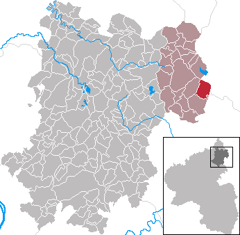
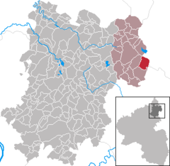
Coordinates 50°35′6″N 8°7′38″E / 50.585°N 8.12722°ECoordinates: 50°35′6″N 8°7′38″E / 50.585°N 8.12722°E Administration Country Germany State Rhineland-Palatinate District Westerwaldkreis Municipal assoc. Rennerod Mayor Klaus Laube Basic statistics Area 6.72 km2 (2.59 sq mi) Elevation 430 m (1411 ft) Population 713 (31 December 2010)[1] - Density 106 /km2 (275 /sq mi) Other information Time zone CET/CEST (UTC+1/+2) Licence plate WW Postal code 56479 Area code 02664 Website www.rennerod.de Oberrod is an Ortsgemeinde – a community belonging to a Verbandsgemeinde – in the Westerwaldkreis in Rhineland-Palatinate, Germany.
Contents
Geography
Location
The community lies in the Westerwald on the boundary with Hesse. The nearest sizeable towns are Siegen (34 km to the north), Wetzlar (27 km to the east) and Limburg an der Lahn (24 km to the south). Through the community flows the Lasterbach. Oberrod belongs to the Verbandsgemeinde of Rennerod, a kind of collective municipality. Its seat is in the like-named town.
Politics
Community council
The council is made up of 12 council members who were elected in a majority vote in a municipal election on 13 June 2004.
Regular events
One of the oldest clubs is the Schützenverein St. Hubertus 1910 Oberrod e.V. (shooting club). Each year at Whitsun the club stages a three-day shooting festival.
A further highlight is the so-called Backes- und Brunnenfest (“Bakehouse and Well Festival”), which takes place from 18 to 20 August at the village well. To eat there is, among other things, the so-called "Flappeskuchen", which is baked in the traditional way in a quaint woodburning oven.
Economy and infrastructure
Transport
East of the community runs Bundesstraße 54, leading from Limburg an der Lahn to Siegen. The nearest Autobahn interchange is Herborn on the A 45 (Dortmund–Hanau), some 23 km away. The nearest InterCityExpress stop is the railway station at Montabaur on the Cologne-Frankfurt high-speed rail line.
References
- ^ "Bevölkerung der Gemeinden am 31.12.2010" (in German). Statistisches Landesamt Rheinland-Pfalz. 31 December 2010. http://www.statistik.rlp.de/fileadmin/dokumente/berichte/A1033_201022_hj_G.pdf.
External links
- Unofficial website of the Ortsgemeinde of Oberrod (German)
- Oberrod in the collective municipality’s Web pages (German)
- This article incorporates information from the German Wikipedia.
Categories:- Municipalities in Rhineland-Palatinate
- Koblenz region geography stubs

Wikimedia Foundation. 2010.