- Nomborn
-
Nomborn 

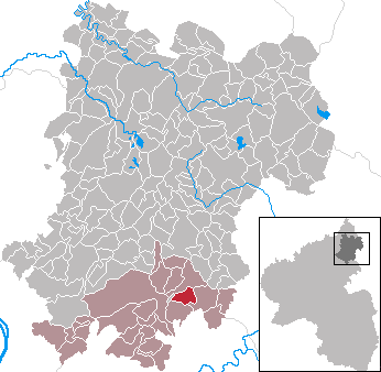
 NombornLocation of Nomborn within Westerwaldkreis district
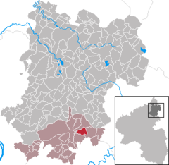
Coordinates 50°25′46″N 7°54′53″E / 50.42944°N 7.91472°ECoordinates: 50°25′46″N 7°54′53″E / 50.42944°N 7.91472°E Administration Country Germany State Rhineland-Palatinate District Westerwaldkreis Municipal assoc. Montabaur Mayor Johannes Hübinger Basic statistics Area 4.00 km2 (1.54 sq mi) Elevation 290 m (951 ft) Population 715 (31 December 2010)[1] - Density 179 /km2 (463 /sq mi) Other information Time zone CET/CEST (UTC+1/+2) Licence plate WW Postal code 56412 Area code 06485 Website www.nomborn.de Nomborn is an Ortsgemeinde – a community belonging to a Verbandsgemeinde – in the Westerwaldkreis in Rhineland-Palatinate, Germany.
Contents
Geography
Location
The community lies in the Westerwald between Montabaur and Limburg an der Lahn on the edge of the Nassau Nature Park. Through the community flows the Eisenbach. The community belongs to the Verbandsgemeinde of Montabaur, a kind of collective municipality. Its seat is in the like-named town.
History
In 1289, Nomborn had its first documentary mention as Numburne.
Politics
Community council
The council is made up of 13 council members, including the extraofficial mayor (Bürgermeister), who were elected in a municipal election on 13 June 2004.
Wählergruppe Hübinger Wählergruppe Frink Total 2004 7 5 12 seats Coat of arms
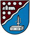
The community’s arms show a stylized representation of Saint Kilian’s Church above. The seven hexagons symbolize the basalt columns found in the area around the Hausberg Bornkasten. Below, the former drinking water supply is symbolized as a well. The wavy bendlet stands for the Eisenbach, which flows through the community.
Economy and infrastructure
Transport
The nearest Autobahn interchange is Diez on the A 3 (Cologne–Frankfurt), some 3 km away. The nearest InterCityExpress stops are the railway stations at Limburg and Montabaur, each 12 km away, on the Cologne-Frankfurt high-speed rail line, and Koblenz on the Rechte Rheinstrecke, some 40 km away.
References
- ^ "Bevölkerung der Gemeinden am 31.12.2010" (in German). Statistisches Landesamt Rheinland-Pfalz. 31 December 2010. http://www.statistik.rlp.de/fileadmin/dokumente/berichte/A1033_201022_hj_G.pdf.
External links
- Nomborn (German)
- This article incorporates information from the German Wikipedia.
Categories:- Municipalities in Rhineland-Palatinate
- Koblenz region geography stubs

Wikimedia Foundation. 2010.