- Nister-Möhrendorf
-
Nister-Möhrendorf 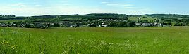


 Nister-MöhrendorfLocation of Nister-Möhrendorf within Westerwaldkreis district
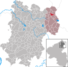
Coordinates 50°39′23″N 8°4′40″E / 50.65639°N 8.07778°ECoordinates: 50°39′23″N 8°4′40″E / 50.65639°N 8.07778°E Administration Country Germany State Rhineland-Palatinate District Westerwaldkreis Municipal assoc. Rennerod Mayor Rolf Haas Basic statistics Area 2.97 km2 (1.15 sq mi) Elevation 530 m (1739 ft) Population 322 (31 December 2010)[1] - Density 108 /km2 (281 /sq mi) Other information Time zone CET/CEST (UTC+1/+2) Licence plate WW Postal code 56477 Area code 02667 Website www.rennerod.de Nister-Möhrendorf is an Ortsgemeinde – a community belonging to a Verbandsgemeinde – in the Westerwaldkreis in Rhineland-Palatinate, Germany.
Contents
Geography
Location
The community lies in the Westerwald between Limburg and Siegen. Through the community flows the Große Nister. Nister-Möhrendorf belongs to the Verbandsgemeinde of Rennerod, a kind of collective municipality. Its seat is in the like-named town.
History
Both places had their first documentary mention in 1300. They were united in 1929.
Politics
Community council
The council is made up of 8 council members who were elected in a majority vote in a municipal election on 13 June 2004.
Economy and infrastructure
Transport
Running right through the community is Bundesstraße 414, leading from Herborn to Hachenburg. The nearest Autobahn interchange is Haiger/Burbach on the A 45 (Dortmund–Aschaffenburg), some 16 km away. The nearest InterCityExpress stop is the railway station at Montabaur on the Cologne-Frankfurt high-speed rail line.
References
- ^ "Bevölkerung der Gemeinden am 31.12.2010" (in German). Statistisches Landesamt Rheinland-Pfalz. 31 December 2010. http://www.statistik.rlp.de/fileadmin/dokumente/berichte/A1033_201022_hj_G.pdf.
External links
- This article incorporates information from the German Wikipedia.
Categories:- Municipalities in Rhineland-Palatinate
- Koblenz region geography stubs


Wikimedia Foundation. 2010.