- Dere Street
-
Dere Street 
Route of Dere Street in blueRoute information Length: 226 mi (364 km)
[146 mi (235 km) Eboracum to Trimontium; 80 mi (129 km) Trimontium to Veluniate]Time period: Roman Britain Major junctions From: Eboracum Isurium, Cataractonium, Morbium, Vinovium, Longovicium, Vindomora, Coria, Onnum, Habitancum, Bremenium, Trimontium, Inveresk, Cramond To: Veluniate Dere Street or Deere Street, (latterly Via Regia in Scotland) was a Roman road between Eboracum (York) and Veluniate, in what is now Scotland. It still exists in the form of the route of many major roads, including the A1 and A68 just north of Corbridge.
Its name corresponds with the post Roman Anglo-Saxon kingdom of Deira, through which the first part of its route lies. It was sometimes referred to as "Watling Street" and marked on some maps as such. This can sometimes cause it to be confused with the Watling Street that linked Dover with Wroxeter.
Contents
In England
York to Catterick
 Dere Street at Brompton-on-Swale
The route began at York[1] and crossed the River Ure near Isurium Brigantum (present-day Aldborough close to Boroughbridge). From there, it crossed the River Swale near Catterick, North Yorkshire, where the Roman fort was called Cataractonium. (Just north of Catterick (at the modern Scotch Corner) the road over Stainmore to Penrith, Carlisle and the Western end of Hadrian's Wall branched off).[2]
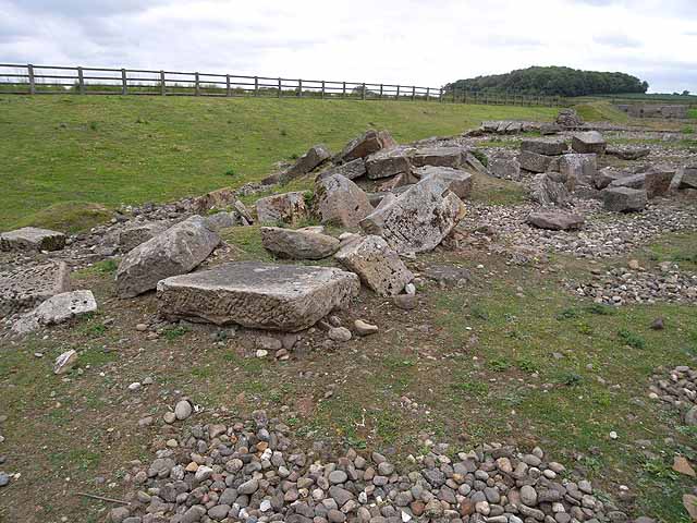
River Tees crossing
Dere Street went on to cross the River Tees near the Roman fort of Piercebridge by a stone arch bridge: These are relatively rare in Roman Britain,[3] except for Hadrian's Wall and Dere Street. The original bridge at Piercebridge was replaced by another on a different alignment, and there is some evidence for other minor realignments of Dere Street over the Roman period.[4] Raymond Selkirk has suggested that the supposed remains of a Roman stone bridge on the south side of the Tees at Cliffe are remains of a jetty, and Time Team investigated this in 2009.[5][6] In 1994, a section through Dere Street was exposed by excavations carried out in a garage development area at Cliffe, and some pottery and tile found.[7][8]
Bishop Auckland to the Cheviot Hills
 Dere Street at Esh Winning
The next river crossing was of the River Wear at the Roman fort of Vinovia, near present-day Bishop Auckland.[9] At this point another road branched away to the right, heading for Durham, Chester-le-Street and eventually crossing the Tyne at Pons Aelius the modern Newcastle.[10]
From Vinovia, Dere Street travelled onwards past the Roman forts of Longovicium (present-day Lanchester) and Vindomora (present-day Ebchester), before crossing the River Tyne near the fort of Coria (Corbridge), where it crossed Stanegate.[11][12] Just North of Corbridge, the route passed through the fortifications of Hadrian's Wall, at a point now known as Portgate, and passed into lands that were only tenuously under Roman domination.[13]
From the Wall, the route continued north into Redesdale and thence to the Cheviot Hills, where there are the remains of marching forts at Fourlaws, Habitancum (West Woodburn), Bremenium (Rochester), and at Chew Green.[13]
In Scotland
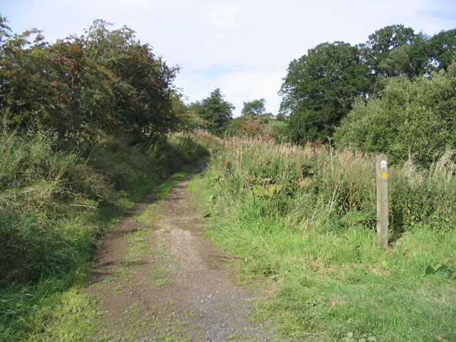
Crossing the present day Scottish border near the present A68 at Carter Fell, there are the remains of a camp at Pennymuir[14] and well preserved sections of the road as it also forms part of St. Cuthbert's Way to Trimontium near Melrose. Crossing the River Tweed at Trimontium the route follows the Leader Water to the foot of the Lammermuirs, where there is evidence of forts near Oxton and another well preserved section of road rises through the Lammermuirs over Soutra hill, and then on to British Din Eidyn, a stronghold of the Votadini tribe, and where the Romans held strategic garrisons at Cramond and at Inveresk to access the eastern end of the Antonine Wall.[15]
After the Romans
 Dere Street close to the Scottish Border
In the High Middle Ages, the section of the route between Jedburgh and Edinburgh was known as the Via Regia or royal way, it connected the larger part of Scotland with the important ecclesiastic sites of the Scottish Borders. King Malcolm IV established his Church and Hospital of the Holy Trinity half way along this section to provide succour for the many pilgrims using it.[16]
After the destruction of the Border Abbeys during "The Rough Wooing" by the Earl of Hertford's forces of Mary, Queen of Scots, and the Reformation of the Scottish Church, the route fell into disuse and disrepair; and it was used mainly for driving livestock, and the occasional travellers daring enough to venture into the lawless border region.[17]
Medieval travel on Dere Street
 14th century packhorse
Dere Street continued in use between Durham and York in medieval times. Being limited by daylight, "about thirty miles in a day in winter on horseback and between thirty-six and forty in summer was what a man could do." Tough, vigorous men could walk from Darlington to York, and it was said that the quality of a horse could make the difference between a possible thirty and fifty miles per day. A wish to hear mass or the organisation of a train by the rich could shorten the travelling day to twenty miles. Roads were described as so muddy and difficult between November and February that in order to finish the journey by daylight one could barely stop to eat; however a "royal highway" or alta via regia strata was passable in winter between York and Durham, and this could have been Dere Street. Heavy packhorse loads were taken on the route, for example 20 stone (130 kg) of wool. Clerics, traders and the nobility were more likely to travel than others, and some people rarely travelled at all. Travelling in style involved the use of carts for luggage, but carts bogged down in winter mud, so traders with packhorses travelled more easily in winter than the rich.[18]
See also
Gallery
-

Legs cross on Dere Street near Bolam in County Durham
-

Dere Street at Bildershaw, County Durham
-

Wheelbirks bridge, Northumberland
-

Milestone at West Woodburn, Northumberland
-

Dere Street at Bonjedward, Scottish Borders
-

Dere Street at Crailinghall, Scottish Borders
-

Dere Street at Maxton, Scottish Borders
-

Dere Street at Gilston, Scottish Borders
Notes
- ^ ie the route of what we now call Dere Street. The Antonine Itinerary gives 3 routes which pass over Dere Street; none actually begin or end in York
Davies, Hugh Roman Roads in Britain Stroud 2002 ISBN 0-7524-2503-X, pp 20-21 - ^ Hayton, Richard (2003). "Yorkshire History.com". Roman military sites in Yorkshire. http://www.yorkshirehistory.com/romans_north_yorks.htm. Retrieved 16 January 2010.
- ^ Davies Roads in Roman Britain p 93
- ^ [1]
- ^ Selkirk, Raymond (2000). Chester-le-Street & Its Place in History. Birtley, County Durham: Casdec Print & Design Centre. pp. 93–122. ISBN 1-900456-05-2.
- ^ Lloyd, Chris (2 July 2009). "The Northern Echo". Piercebridge: Time Team investigates. http://www.thenorthernecho.co.uk/features/blogs/staff/echomemories/4472760.Time_Team_in_the_area/. Retrieved 12 January 2010.
- ^ "Heritage Gateway". Listed buildings online, and local records. http://lbonline.english-heritage.org.uk. Retrieved 11 January 2010.
- ^ NY SMR Number MNY12855; Old Sites & Monuments Record Number 12975.10000; Grid Reference NZ 212 155; SNY8056 Field recording Form, North Yorkshire County Council 15/11/1994, George Hotel Piercebridge (Dere Street Cottage), Campling, N. NYCC Observation Record
- ^ Laurie, Barbara (2005). "bishopaucklandhistory.co.uk". A Short History of Bishop Auckland. http://www.bishopaucklandhistory.co.uk/. Retrieved 16 January 2010.
- ^ "Pastscape, English Heritage". Dere Street Investigation History. Publications : Full report Proceedings of the Society of Antiquaries of Newcastle upon Tyne 2/1925/12:94-6. http://pastscape.english-heritage.org.uk/events.aspx?a=0&hob_id=1005251&type=&class1=None&period=None&county=None&place=corbridge&yearfrom=ALL&yearto=ALL&recordsperpage=60&source=text&sort=1&nmr=&defra=. Retrieved 16 January 2010.
- ^ Bishop, M.C.. "Durham.ac.uk resources". Corbridge (archaeological resources). http://www.dur.ac.uk/resources/archaeological.services/research_training/hadrianswall_research_framework/project_documents/Corbridge.pdf. Retrieved 16 January 2010.
- ^ Stanegate and Dere Street were about the same width (7.7m) but the much greater depth of metalling on Stanegate (72cm as against 30cm on Dere Street) is argued to reflect a greater frequency of resurfacing, and hence much greater traffic on Stanegate Davies Roads in Roman Britain p 57
- ^ a b "BBC". Dere Street - From York to Melrose in Seven Days. 10 June 2009. http://www.bbc.co.uk/dna/h2g2/A49097587. Retrieved 16 January 2010.
- ^ Pennymuir camps under snow
- ^ "Historic Scotland". Dere Street Roman Road. http://www.historic-scotland.gov.uk/index/places/propertyresults/propertydetail.htm?PropID=PL_087&PropName=Dere%20Street%20Roman%20Road,%20Soutra. Retrieved 16 January 2010.
- ^ Hunter, James, FSA (Scot)., Fala and Soutra, including a History of the Ancient "Domus de Soltre", Edinburgh, 1892.
- ^ Scotways.com. "Heritage Paths". Dere Street. http://www.heritagepaths.co.uk/pathdetails.php?path=197. Retrieved 16 January 2010.
- ^ Harvey, Margaret M. (March 2005). "Travel from Durham to York (and back) in the fourteenth century". Northern History (Durham University Library) 1 (XLII): 119–130. http://dro.dur.ac.uk/2271/1/2271.pdf. Retrieved 16 January 2010.
Further reading
- The Roads of Mediaeval Lauderdale, by R. P. Hardie, Edinburgh & London, 1942.
External links
- Dere street trail (Durham county council)
- A look at some of the ancient roads passing through East Lothian, including a section of Dere Street
- BBC: Dere Street - From York to Melrose in Seven Days
Ancient Rome
Outline · TimelineEpochs Constitution Government Magistrates - Extraordinary: Dictator
- Magister Equitum
- Decemviri
- Consular Tribune
- Triumvir
- Rex
- Interrex
Law Military Economy - Agriculture
- Deforestation
- Commerce
- Finance
- Currency
- Republican currency
- Imperial currency
- SPQR
Technology Culture Society Language
(Latin)- Versions: Old
- Classical
- Vulgar
- Late
- Medieval
- Renaissance
- New
- Contemporary
- Ecclesiastical
Writers Lists Major cities Categories:- Roads in Scotland
- Roman roads in Britannia
- Scottish Borders history
- History of Northumberland
- Roman sites in County Durham
- Roman sites in Northumberland
- Archaeological sites in the Scottish Borders
-


Wikimedia Foundation. 2010.