- Cherry Creek Bridge
-
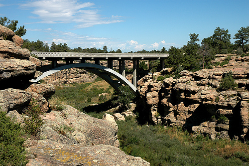
Cherry Creek Bridge 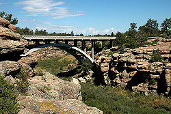
Carries Passenger vehicles Crosses Cherry Creek Locale near Franktown, Colorado Total length 374 ft (114 m) Width 29.8 ft (9.1 m) Longest span 232 ft (71 m) Construction end 1948 Coordinates 39°19′43.43″N 104°44′4.05″W / 39.3287306°N 104.7344583°WCoordinates: 39°19′43.43″N 104°44′4.05″W / 39.3287306°N 104.7344583°W Cherry Creek Bridge

Nearest city: Franktown, Colorado Coordinates: 39°19′52″N 104°44′2″W / 39.33111°N 104.73389°WCoordinates: 39°19′52″N 104°44′2″W / 39.33111°N 104.73389°W Area: less than one acre Architect: Colorado Department of Highways; Monaghan, J.H.& N.M. & Associates Architectural style: Two-rib open-spandrel arch Governing body: State MPS: Highway Bridges in Colorado MPS NRHP Reference#: 02001147[1] Added to NRHP: October 15, 2002 The Cherry Creek Bridge is a concrete arch bridge spanning Cherry Creek near Franktown, Colorado. State Highway 83 runs atop it. It was built in 1948 by J.H.& N.M. Monaghan & Associates and is listed on the National Register of Historic Places. It is located within Castlewood Canyon State Park.
Its design and construction are credited to the Colorado Department of Highways and J.H.& N.M. & Associates.[1]
It was a post-war exception to the practice of using lighter concrete bridge designs in the state.[2] :77
See also
References
- ^ a b "National Register Information System". National Register of Historic Places. National Park Service. 2009-03-13. http://nrhp.focus.nps.gov/natreg/docs/All_Data.html.
- ^ Clayton B. Fraser. (March 30, 2000). "Highway Bridges in Colorado MPS". National Park Service. http://pdfhost.focus.nps.gov/docs/NRHP/Text/64500799.pdf.
U.S. National Register of Historic Places Topics Lists by states Alabama • Alaska • Arizona • Arkansas • California • Colorado • Connecticut • Delaware • Florida • Georgia • Hawaii • Idaho • Illinois • Indiana • Iowa • Kansas • Kentucky • Louisiana • Maine • Maryland • Massachusetts • Michigan • Minnesota • Mississippi • Missouri • Montana • Nebraska • Nevada • New Hampshire • New Jersey • New Mexico • New York • North Carolina • North Dakota • Ohio • Oklahoma • Oregon • Pennsylvania • Rhode Island • South Carolina • South Dakota • Tennessee • Texas • Utah • Vermont • Virginia • Washington • West Virginia • Wisconsin • WyomingLists by territories Lists by associated states Other  Category:National Register of Historic Places •
  Portal:National Register of Historic PlacesCategories:
- Arch bridges
- Road bridges in Colorado
- Buildings and structures in Douglas County, Colorado
- Bridges on the National Register of Historic Places in Colorado
- Bridges completed in 1948
- Transportation in Douglas County, Colorado
- United States bridge (structure) stubs
- Colorado Registered Historic Place stubs

Wikimedia Foundation. 2010.