- Crawford Street Bridge
-
Coordinates: 43°38.95′N 79°24.9′W / 43.64917°N 79.415°W
Crawford Street Bridge 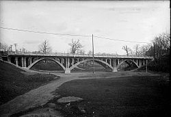
Carries single vehicle lanes for both directions Crosses Garrison Creek Locale Toronto, Ontario, Canada Design triple span arch bridge Total length 52 metres (170 feet) - approx. Vertical clearance unlimited Opened 1915
Crawford Street Bridge is one of two known bridges that once spanned over Garrison Creek valley (the actual creek disappeared as brick sewer in 1885 [1]) in Toronto, Canada, and buried intact in the 20th century. The bridge shares design features with the larger Prince Edward Viaduct.The Crawford Bridge was a triple span Arch bridge built in 1914 to 1915 to replace an early wooden bridge (1884) that spanned Garrison Creek in the area known today's as Trinity-Bellwoods[2]. The bridge's design was influenced by Public Works Commissioner R.C. Harris with a more pleasing structure for the public. The bridge was built to allow residents in the new residential development along Crawford Street to cross over the valley over from north of Lobb Avenue to south of Dundas Street West.
In the 1960s the valley of either sides was filled in with earth dug from building the Bloor subway. It was the last of few bridges that spanned Garrison Creek to be removed, most before the 1940s. The actual bridge was not torn down, but rather buried with only the railings and lampost removed. The city performed maintenance work in 2004 work that narrowed the roadbed and rebuilt sidewalks on both side. Foaming grout was added to fill the voids of the bridge with hope for future restoration of the entire bridge.[3] Today there are no visible signs of the bridge being present other than plaques and sidewalk markers added in 2008 by the city.
Once rolling landscape, houses and flat Trinity Bellwoods Park now surround the bridge.
See also
Other bridges that used to span Garrison Creek:
- Harbord Street Bridge
- Shaw Street Bridge - a wood bridge over Sully Crescent and Garrison Creek was filled in by the 1920s[4]
References
External links
 Bridges in Toronto
List of bridges over Don River
south to northCherry Street Bridge · Gardiner Expressway · Waterfront Trail Pedestrian/Cycle Bridge · Don Valley Parkway southbound on ramp to Gardiner Expressway · Don Valley Parkway southbound on ramp to Gardiner Expressway · Five lane railway bridge · Eastern Avenue bridge · Don Valley Parkway off ramp to westbound Eastern Avenue · Queen Street Viaduct · Dundas Street · Gerrard Street · Pedestrian bridge connecting east and west sides of Riverdale Park · Don River Railway bridge#1 · Prince Edward Viaduct · Rosedale Valley Bridge · Bloor Bayview Ramp for Don Valley Parkway access · Don River Railway bridge#2 · Pottery Road Bridge · Don River Railway bridge#3 · Beechwood Drive cycle bridge · Don River Railway Bridge#4 · Leaside BridgeEast Don River West Don River Humber River Queensway-Humber overpass · Bloor Street-Humber River overpass · Bloor-Danforth Subway-Humber River overpass · Old Mill Road Bridge · Dundas Street West overpass · Lambton Mills railway bridge · Scarlett Road overpass · Eglinton Avenue West overpass · Lawrence Avenue West overpass · St Phillips Street overpass · Humber River Bridge (Weston Golf and Country Club) · Highway 401-Humber River overpasses · Albion Road overpass · Finch Avenue West-Islington Avenue overpasses · Steeles Avenue West overpassList of bridges over Mimico Creek List of bridges over Etobicoke Creek Other Crawford Street Bridge, Harbord Street BridgeOverpasses Railway overpasses Railway tracks Pedestrian Amsterdam Bridge · Glen Manor Bridge · Humber Bay Arch Bridge · Lake Shore Boulevard Bailey Bridge · Old Finch Avenue Bailey BridgeOther bridges over waterways Categories:- Bridges in Toronto
- Deck arch bridges
- Concrete bridges

Wikimedia Foundation. 2010.