- Mimico Creek
-
Mimico Creek River 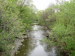 Mimico Creek as it flows through Etobicoke, south of Bloor Street.
Country Canada State Ontario Cities Toronto, Brampton, Ontario Source - location near Professor's Lake, Ontario, Canada Mouth - location Humber Bay Park, Toronto, Ontario, Canada Length 33 km (21 mi) Basin 77 km2 (30 sq mi) Mimico Creek is a 33 km watercourse with its headwaters in Brampton, Ontario, and its mouth in Toronto, Ontario.[1] The watershed lies between the Humber River to the east and Etobicoke Creek to the west. It flows through the community of Malton, Ontario, Canada, now part of Mississauga; It flows southeast, past Pearson Airport; through a shallow valley surrounded by the urban neighbourhoods of Islington and Mimico, now part of Toronto. The creek is often encased in a concrete spillway to contain the fast flowing water that occurs during rainstorms. Mimico Creek crosses Bloor Street near the Islington Subway Station. It empties into Lake Ontario about 1 km west of the mouth of the Humber.
In the 1990s a large park called Humber Bay Park was constructed at the mouth of Mimico Creek. The park consists of two headlands built on landfill from local construction projects. Due to the name of the park, Mimico Creek is often mistaken for the Humber River.
See also
References
- ^ "The Malton Environmental Stewardship Project". Toronto and Region Conservation Authority. http://www.trca.on.ca/Website/TRCA/Website.nsf/Webpage/trca__events__stewardship_programs__default_asp_load_malton?OpenDocument&Language=EN. Retrieved 2007-12-30.[dead link]
External links
Toronto ravine system Black Creek · Castle Frank Brook · Don River · Etobicoke Creek · Garrison Creek · German Mills Creek · Highland Creek · Humber River · Keating Channel · Mimico Creek · Rouge River · Russell Creek · Taddle Creek · Taylor-Massey CreekCoordinates: 43°37′20″N 79°29′00″W / 43.622311°N 79.483284°W
Categories:- Rivers of Ontario
- Rivers of Toronto
- Tributaries of Lake Ontario
- Golden Horseshoe geography stubs

Wikimedia Foundation. 2010.