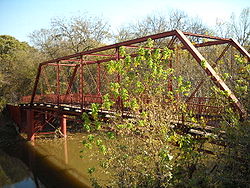
- Old Alton Bridge
-
Old Alton Bridge
 Old Alton Bridge
Location: Old Alton Road Nearest city: Copper Canyon, Texas Coordinates: 33°7′45.3534″N 97°6′15.3714″W / 33.129264833°N 97.104269833°WCoordinates: 33°7′45.3534″N 97°6′15.3714″W / 33.129264833°N 97.104269833°W Built: 1884 Architect: King Iron & Bridge Manufacturing Co. NRHP Reference#: 88000979 Added to NRHP: July 8, 1988 Old Alton Bridge is a historic iron through-truss bridge connecting the cities of Denton, Texas and Copper Canyon, Texas. Built in 1884 by the King Iron Bridge Manufacturing Company, it originally carried horses and later automobiles over Hickory Creek at a location that once was a popular ford for crossing cattle. The bridge takes its name from the abandoned community of Alton, which between 1850-1856 was the seat of Denton County.[1]
The heavily traveled Old Alton Bridge remained in constant use until 2001 when vehicle traffic was moved to an adjacent concrete-and-steel bridge. Prior to the new bridge, it was necessary for motorists to signal with a car horn before crossing the single lane span. The new bridge straightened out a sharp curve on both sides of the creek and provided additional travel lanes.
With vehicle traffic removed, the bridge became an important link connecting the Elm Fork and Pilot Knoll Hiking and Equestrian Trails. Today it is a popular location for nature enthusiasts and photographers. Old Alton Bridge was included in the National Register of Historic Places, July 8, 1988.
Goatman's Bridge
Locally, the bridge is known as "Goatman's Bridge", due to a legendary demonic satyr of the same name, who is popularly believed to inhabit the forest surrounding the area.
Alternatively, legend tells of a black goat farmer who moved his family to a residence just north of the bridge. A few years later, Oscar Washburn was known as a dependable, honest businessman. North Texans endearingly began to call him the Goatman. But the success of a black man was still unwelcome to many, and Klansmen in the local government turned to violence after he displayed a sign on Alton Bridge: "this way to the Goatman's".
In August 1938 Klansmen crossed the bridge and kidnapped Washburn from his family. They hung a noose on Old Alton Bridge and, after securing it around his neck, threw him over the side. When they looked down to see if he had died, the noose was empty. In a panic, they returned to his family home and slaughtered his wife and children.[2]
Locals warn that if you crossed the bridge at night without headlights, you will be met on the other side by the Goatman. Ghostly figures and strange lights are also reported in the surrounding woods. This legend results in the area around Old Alton Bridge being popular with paranormal societies and Halloween activities.[3]
Gallery
References
- ^ David Minor, "ALTON, TX (DENTON COUNTY)", Handbook of Texas Online, accessed November 14, 2010
- ^ Alton, Texas and Goatman’s Bridge Legends of America
- ^ Old Alton Bridge The Trails of Denton County
U.S. National Register of Historic Places Topics Lists by states Alabama • Alaska • Arizona • Arkansas • California • Colorado • Connecticut • Delaware • Florida • Georgia • Hawaii • Idaho • Illinois • Indiana • Iowa • Kansas • Kentucky • Louisiana • Maine • Maryland • Massachusetts • Michigan • Minnesota • Mississippi • Missouri • Montana • Nebraska • Nevada • New Hampshire • New Jersey • New Mexico • New York • North Carolina • North Dakota • Ohio • Oklahoma • Oregon • Pennsylvania • Rhode Island • South Carolina • South Dakota • Tennessee • Texas • Utah • Vermont • Virginia • Washington • West Virginia • Wisconsin • WyomingLists by territories Lists by associated states Other  Category:National Register of Historic Places •
  Portal:National Register of Historic PlacesCategories:
- Buildings and structures in Denton County, Texas
- Bridges completed in 1884
- Bridges on the National Register of Historic Places in Texas
- King Bridge Company
- Transportation in Denton County, Texas
- Road bridges in Texas
- Pedestrian bridges in Texas
- Former road bridges in the United States
Wikimedia Foundation. 2010.


