- Chalan Beel
-
Chalan Beel 
Chalan Beel in Natore District Location Rajshahi Division Primary inflows Atrai River and 46 others Basin countries Bangladesh Surface area Canadian portion 26 km2 (10 sq mi) Average depth 2 m (6.6 ft) Max. depth 4 m (13 ft) 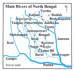
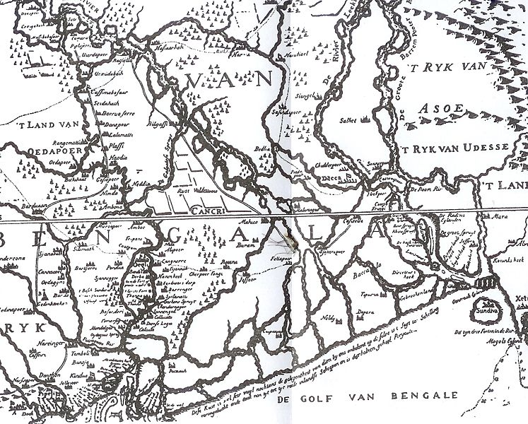
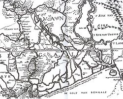 Van den Brouck’s map of 1660
Chalan Beel (Bengali: চলনবিল) is a wetland in Bangladesh. It is a large inland depression, marshy in character, with rich flora and fauna. Forty-seven rivers and other waterways flow into the Chalan Beel.[1] As silt builds up in the beel, its size is being reduced.[2]
Contents
Location and extent
Chalan Beel is an extensive lowland area in the lower Atrai basin, and spreads across Singra and Gurudaspur upazilas on Natore District, Chatmohar, Bhanga and Faridpur upazilas of Pabna District, and Ullahpara, Raiganj and Tarash upazilas of Sirajganj District. It consists of a series of beels connected to one another by various channels to form a continuous water body during the rainy season. Although the beel area expands into a vast water body with dense aquatic vegetation as long as the Jamuna remains flooded during the monsoon months, it dries out in the winter months, leaving only patches of water in the central parts of this zone.[3]
Chalan Beel is fast silting up. In the past it covered an area of about 1,085 km² but was reduced to 368 km² in 1909, of which only 85 km² remained underwater throughout the year. It has since shrunk to only 26 km².[2]
History
The most important factor dominating the river history in Bengal is the large proportion of silt carried by its rivers. It is the silt which has created the land and made it habitable by building it up through the centuries. It is silt which is fertilising the land, but the silt, which has been the most beneficial gift of nature, has also produced most of the river problems now confronting the people of Bengal. Silt deposited in the old river channel beds has forced them to change course, creating problems for abandoned areas while assisting in developing new areas.[4]
The main volume of water from the Ganges River began flowing through the Padma channel in the sixteenth century. Silt from the Padma helped in building up the southern portion of north Bengal. This is the most plausible explanation for the existence of a depression around Chalan Beel. The Teesta was active in the region until it changed its course in 1787. This territory lies in between the land raised in the north by the Teesta system when it was active and that in the south by the Padma.[5]
However, there is another explanation for the creation of the depression. The Padma has been changing its course over the centuries. In Ven den Brouck's map of Bengal, prepared in 1660, the main channel of the Padma is shown as flowing through Faridpur-Bakharganj, but there also is a suggestion of another, possibly earlier channel. This channel runs through Rampur Boalia in Rajshahi, Chalan Beel, Dhaleswari and Buriganga before meeting the Meghna. At that time the Jamuna was virtually non-existent and the Brahmaputra used to flow through its old channel.[6]
Impact of railways
An estimate taken in 1945 found about 47 rivers and other waterways flowed into the Chalan Beel, a watershed of about 1,547 square miles (4,010 km2). In addition to being a crossroads for the many waterways it also served as the origin for the many rivers flowing south or east that eventually meet with the Padma or Jamuna. In the early 1900s, Chalan Beel began to be hemmed in by the construction of the East Bengal Railway main line on the west and the Santahar-Bogra branch line on the north. The natural pattern of the water's drainage channels in this area were disrupted by the obstruction caused by the railway construction since railways in these low lands had to be built on embankments.[1]
Flora and fauna
The banks of the beel are covered with dense stands of kash , babla, nol, dhol kolmi, simul, and date palm. Seven species of frogs and one species of toad represent the amphibian fauna. Chalan Beel has a total of 34 species of reptiles include ten turtles and tortoises, nine lizards and various snake species. There are 27 species of mammals from 12 families.[3]
References
- ^ a b "Our Indian Railway: Themes in India’s Railway History". Book Preview. Foundation Books Pvt. Ltd., 4381/4 Ansari Road, Daryaganj, New Delhi – 110002, ISBN 81-7596-330-1. http://books.google.com/books?id=O2-eHnajWxIC&pg=PA176&lpg=PA176&dq=chalan+beel&source=web&ots=V6mdGXnBF4&sig=6Yvhm4w84kCxOXlM9z3UjlpVam4#PPA177,M1. Retrieved 2007-11-29.
- ^ a b Mohd Shamsul Alam, and Md Sazzad Hossain. "Chalan Beel". Banglapedia. Asiatic Society of Bangladesh. http://banglapedia.search.com.bd/HT/C_0101.htm. Retrieved 2007-11-23.
- ^ a b "Bio-ecological zones of Bangladsh". International Union for Conservation of Nature and natural Resources Bangladesh Country Office. http://books.google.com/books?id=HT4p-7uG3cUC&pg=PA32&lpg=PA32&dq=chalan+beel&source=web&ots=VU7fKdMuUX&sig=xvjR_6w7IGLjUEKjS7hjeiR6UqQ#PPA32,M1. Retrieved 2007-11-29.
- ^ Majumdar, S.C., Chief Engineer, Bengal, Rivers of the Bengal Delta, Government of Bengal, 1941, reproduced in Rivers of Bengal, Vol I, 2001, p. 101, published by Education Department, Government of West Bengal.
- ^ Majumdar, S.C., p. 46
- ^ Roy, Niharranjan, Bangalir Itihas, Adi Parba, (Bengali), first published 1972, reprint 2005, p. 83, Dey’s Publishing, 13 Bankim Chatterjee Street, Kolkata, ISBN 81-7079-270-3
See also
Rivers in and around Bengal Southeast Bangladesh Assam / Meghalaya /
TripuraBarak · Brahmaputra · Feni · Kangsha · Kushiyara · Manu · Meghna · Muhuri · Someshwari · Surma · Surma-Meghna · Titas / Haora · Gumti · KhowaiNorthern Bangladesh
North BengalAtrai · Balason · Bangali · Baral · Dharla · Dhepa · Gumani · Jaldhaka · Karatoya · Khong Khola · Mahananda · Mechi · Punarbhaba · Raidak or Wong Chhu · Rangeet · Tangon · Teesta · Torsa/Machu/Amo ChhuCentral Bangladesh Bangshi · Buriganga · Dhaleshwari · Gorai-Madhumati · Jamuna · Louhajang · Padma · Shitalakhya · TuragChotanagpur Ajay · Bakreshwar · Bansloi · Barakar · Brahmani · Damodar · Dwarka · Dwarakeswar · Gandheswari · Haldi · Hinglo · Kangsabati · Keleghai · Kopai · Kosai · Kunur · Mayurakshi · Mundeswari · Rasulpur · Rupnarayan · Sali · Shilabati · SubarnarekhaSouth Bengal
Ganges DeltaAdi Ganga · Baleshwar · Bidyadhari · Bura Gauranga · Churni · Gosaba · Hariabhanga · Hooghly · Ichamati · Jalangi · Kalindi · Matla · Muri Ganga · Pasur · Piyali · Raimangal · Saptamukhi · Saraswati · ThakuranRelated topics Beel · Country boats in Bangladesh · Chalan Beel · Ganges · Haor · Haors in Bangladesh · List of rivers of Bangladesh · of India · Waters of South Asia · Damodar Valley CorporationHydrology of surrounding areas Orissa • Jharkhand • Bihar • Nepal • Sikkim • Bhutan • North-east IndiaCategories:- Geography of Bangladesh
- Wetlands of Bangladesh


Wikimedia Foundation. 2010.