- Dharla River
-
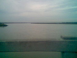 Dharla River in Kurigram.
The Dharla River (Bengali: ধরলা নদী, Dhorola nodi) is one of Bangladesh's trans-boundary rivers. It originates in the Himalayas where it is known as the Jaldhaka River, and then it flows through the Jalpaiguri and Cooch Behar districts of West Bengal, India, one of the seven main rivers to do so. Here the river enters Bangladesh through the Lalmonirhat District and joins with the Jaldhaka River and flows as the Dharla River until it empties into the Brahmaputra River near the Kurigram District. Near Patgram Upazila, it again flows easternly back into India. Suddenly it turns south and enters Bangladesh for the second time through Phulbari Upazila of Kurigram District and continues a slow meandering course.[1]
The average depth of river is 12 feet (3.7 m) and maximum depth is 39 feet (12 m), in origin of Kurigram.
Erosion by the rivers Dharla and Jamuna took a serious turn in Lalmonirhat in 2007. In Lalmonirhat, about two kilometres of seven kilometre-long flood control embankment was devoured by the Dharla. Three mosques, two temples, a madrassah and a primary school, and a vast tract of cultivable land with crops were devoured by the river, rendering about three thousand people homeless.[2]
There is a park beside the Dharla at Kurigram. There also is a bridge. The river is full during the monsoon season but has only knee-deep water in summer. Deposition of silt has led to the formation of many small islands (chars) in the river.[3]
References
- ^ "Dharla". Banglapedia. http://banglapedia.search.com.bd/HT/D_0187.htm. Retrieved 2007-07-17.
- ^ Erosion of Dharla, Jamuna worsens
- ^ Khokon, Leaquat Hossain, 64 Jela Bhraman, 2007, pp.14-15, Anindya Prokash, Dhaka, ISBN 984-8740-19-8
See also
Categories:- Rivers of Bangladesh
- Rivers of West Bengal
- International rivers of Asia
- Rivers of Sikkim

Wikimedia Foundation. 2010.