- Jalangi River
Geobox River
name = Jalangi River
native_name =
other_name =
other_name1 =
image_size =
image_caption =
etymology =
country = India
country1 =
state =
state1 =
region =
region1 =
district =
district1 =
city = Krishnanagar,Tehatta
city1 = Mayapur
landmark =
landmark1 =
landmark 2 =
length =
watershed =
discharge_location = Bhagirathi-Hooghly
discharge =
discharge_max =
discharge_min =
discharge1_location =
discharge1 =
source_name = Padma
source_location =
source_district =
source_region =
source_state =
source_country =
source_lat_d =
source_lat_m =
source_lat_s =
source_lat_NS =
source_long_d =
source_long_m =
source_long_s =
source_long_EW =
source_elevation =
source_length =
mouth_name =
mouth_location =
mouth_district =
mouth_region =
mouth_state =
mouth_country =
mouth_lat_d =
mouth_lat_m =
mouth_lat_s =
mouth_lat_NS =
mouth_long_d =
mouth_long_m =
mouth_long_s =
mouth_long_EW =
mouth_elevation =
tributary_left =
tributary_left1 =
tributary_right =
tributary_right1 =
free_name =
free_value =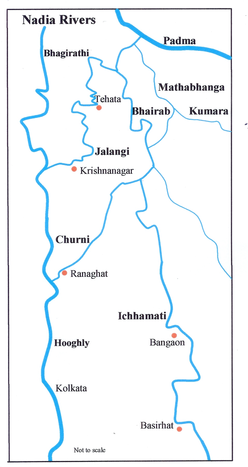
map_size =
map_caption =Jalangi River ( _bn. জলজ্ঞী নদী), is a branch of the Ganges in Murshidabad and Nadia districts in the
India n state ofWest Bengal . The Jalangi and the Mathabhanga flow into the Bhagirathi-Hooghly and strengthens its lower channel, the Hooghly. [Majumdar, Dr. R.C., "History of Ancient Bengal", First published 1971, Reprint 2005, p. 4, Tulshi Prakashani, Kolkata, ISBN 81-89118-01-3.]The river below the point where the Jalanagi meets the Ganges is known as Hooghly and the course above it from the point of its separation from the main flow of the Ganges to its confluence with the Jalangi, it is called Bhagirathi. [Bandopadhyay, Dilip Kumar, "Bharater Nadi" (Rivers of India), 2002, Bn icon, p. 68, Bharati Book Stall, 6B Ramanath Mazumdar Street, Kolkata]
Ghurni , a neighbourhood of Krishnanagar, a centre for the production of clay dolls, often referred to as Krishnanagar clay dolls, is located on the banks of the Jalangi.Mayapur is located at the confluence of the Jalanagi and Ganges.Changes in the course of rivers
The Jalangi is a modern stream, but its age is not known. Apparently it opened up long after the Bhairab ran as a strong stream in a south easterly direction. Although it is generally believed that the river has opened up within the last few hundred years, there is no direct evidence of this.Hirst, Major F.C., Director of Surveys, Bengal and Assam, "Report on the Nadia Rivers 1915", first published in 1916 by the Bengal Secretariat Book Depot, reproduced in "Rivers of Bengal", Vol III, p.27, West Bengal District Gazetteers, Higher Education Department, Government of West Bengal, 2002.] It is shown in Van den Brouck’s map. [Roy, Niharranjan, "Bangalir Itihas, Adi Parba", Bn icon, first published 1972, reprint 2005, p. 84, Dey’s Publishing, 13 Bankim Chatterjee Street, Kolkata, ISBN 81-7079-270-3]
The Bhairab once flowed from the Ganges, across the present beds of the Jalangi, and further eastwards towards Faridpur. The Bhairab is no more a very active river. The Mathabhanga is a younger stream than Jalangi and it was not till very recently that the river completed its junction with the Hooghly by adopting the Churni (now its lower reaches) for its main course. Earlier most of the water of the Mathabhanga ran off to the east down the Kumara, Chitra, Coboduk (Bhairab), and Ichamati, but all these escape routes have been shut off, except a small amount for the Ichamati.
The point to note is that while earlier the rivers in the region flowed in a south-easterly direction, but later some force pulled the Jalangi and the Mathabhanga in a south-westerly direction. The inference is that it occurred because of a local subsidence, which was active for some period prior to 1750 and which has since become inactive.
Erosion
Erosion of the banks is not only a problem for the more turbulent rivers such as Padma and Bhagirathi, but also comparatively smaller rivers such as Jalangi. In 2006, the state government sanctioned Rs. 7 crore for anti-erosion work in the Jalangi River. [cite web |url= http://www.thestatesman.net/page.arcview.php?clid=23&id=115823&usrsess=1
title= Rivers wreak havoc|last=Pramanick |first= Asim | work= Bengal| publisher= "The Statesman", 27 August 2005| accessdate=2007-11-28 ] [cite web |url= http://www.thestatesman.net/page.arcview.php?clid=6&id=153394&usrsess=1
title= Rs. 63 crore to stem erosion in Nadia|last= |first= | work= Bengal| publisher= "The Statesman", 11 August 2006| accessdate=2007-11-28 ]Bridge
A sum of Rs 10.76 crore has been sanctioned for the construction of a bridge across the Jalangi at Radhanagar from additional central assistance funds. Besides connecting the districts of Murshidabad and Nadia, the proposed bridge would be an alternative connection to National Highway-34, which links North Bengal with Kolkata. [cite web |url= http://www.thestatesman.net/page.arcview.php?clid=22&id=189075&usrsess=1
title= Adhir push for bridge|last= |first= | work= Kolkata Plus| publisher= "The Statesman", 4 July 2007| accessdate=2007-11-28 ]Bengali poetry
The Jalangi is emotionally referred to by the modern Bengali poet
Jibanananda Das in his poem "abar asibo phire": [Bandopadhyay, Dilip Kumar, p. 226] [cite web |url= http://victorian.fortunecity.com/canal/178/file/zibon12.htm
title= Zibananada Das |last= |first= | work= Abar Asibo Firey| publisher= Fortune City| accessdate=2007-11-28 ]:abar asibo ami banglar nodi math khet bhalobeshe:jalangir dheuey bheja banglar e korun dangaey
::When again I come, smitten by Bengal's rivers and fields, to this::Green and kindly land, Bengal, moistened by the Jalangi river's waves.
References
ee also
Wikimedia Foundation. 2010.