- Ichamati River
Geobox River
name = Ichamati River
native_name =
other_name =
other_name1 =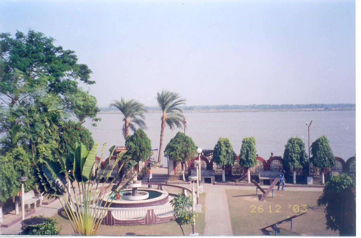
image_size =
image_caption = View from Taki Guest House. The shores of Bangladesh are visible on the other side of Ichamati River.
etymology =
country = Bangladesh
country1 = India
state =
state1 =
region =
region1 =
district =
district1 =
city =
city1 =
landmark =
landmark1 =
landmark 2 =
length =
watershed =
discharge_location =
discharge =
discharge_max =
discharge_min =
discharge1_location =
discharge1 =
source_name =
source_location =
source_district =
source_region =
source_state =
source_country =
source_lat_d =
source_lat_m =
source_lat_s =
source_lat_NS =
source_long_d =
source_long_m =
source_long_s =
source_long_EW =
source_elevation =
source_length =
mouth_name =
mouth_location =
mouth_district =
mouth_region =
mouth_state =
mouth_country =
mouth_lat_d =
mouth_lat_m =
mouth_lat_s =
mouth_lat_NS =
mouth_long_d =
mouth_long_m =
mouth_long_s =
mouth_long_EW =
mouth_elevation =
tributary_left =
tributary_left1 =
tributary_right =
tributary_right1 =
free_name =
free_value =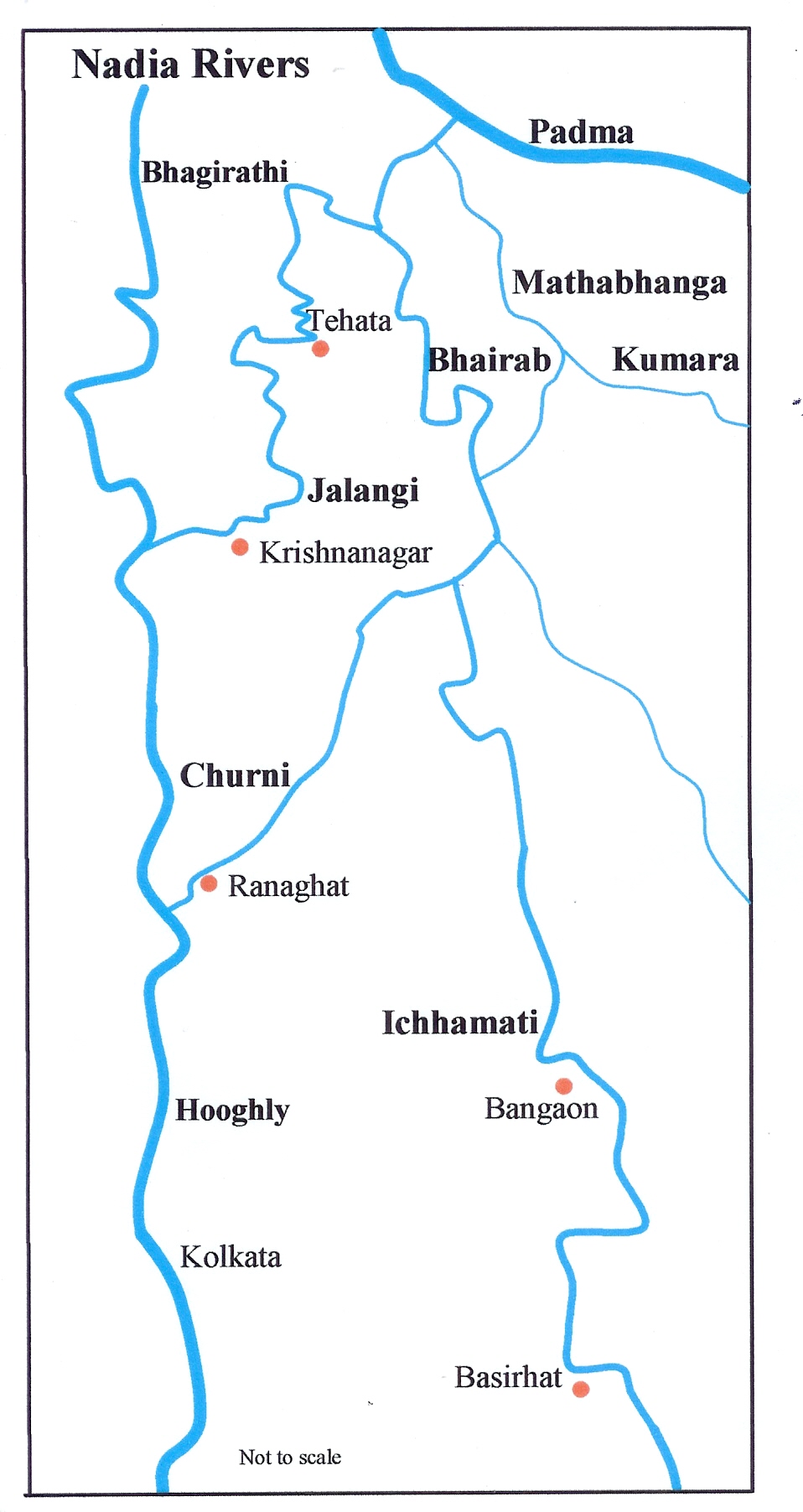
map_size =
map_caption = The lower Ichamati channel flows criss-cross through India and BangladeshIchamati River ( _bn. ইছামতি নদী)(also spelt Ichhamati), is a
trans-boundary river which flows throughIndia andBangladesh and also forms the boundary between the two countries.cite web | url = http://banglapedia.org/ht/I_0013.HTM | title = "Ichamati" | accessdate = 2007-12-10 | last = Ahmed | first = Tamina | work = Banglapedia | publisher = Asiatic Society of Bangladesh] The river is facing the problem of siltation leading to thin flow of water in the dry season and floods in the rainy season. Experts are handling the situation and remedial matters are being discussed between the governments of India and Bangladesh. cite web | url = http://209.85.175.104/search?q=cache:gO6GAUkcaogJ:sfr-india.org/Docs/Achievements_L.pps+Ichhamati&hl=en&ct=clnk&cd=33&gl=in
title = "Overview of Conservation and Development of Affected Rivers in South Bengal" | accessdate = 2007-12-10 | last =Basu | first = Biplab Bhusan | work = | publisher = School of Fundamental Research]Ichamati flow
Ichamati River is now in three parts – (1) The longer part flows from the Mathabhanga River, a
distributary of the Padma, and after flowing for 208 km joins the Kalindi River nearHasnabad inNorth 24 Parganas and Debhata inSatkhira District . (2) Once the main river west of Dhaka and (3) Ichamati of Dinajpur. of 1764-66, shows the last two rivers as one. According to a number of hydrologists, the three Ichamati rivers, in the past, were a single channel.The second river marked above originates south of Jafarganj opposite to the mouth of the Hoorsagar near Nathpur factory and runs towards Joginighat in Munshiganj. Joginighat is situated at the confluence of the Jamuna and the Ichamati. There are five pilgrimage
ghats along the river locally known as Panchatirtha ghats -Tirthaghat, Agla, Solepur, Barunighat and Joginighat.Lower Ichamati
The Mathabhanga River originates from the rightbank of the Padma, at Munshiganj in
Kushtia District in Bangladesh. It bifurcates near Majidia inNadia District in India, creating two rivers, Ichamati and Churni. After traversing a length of 19.5 km in India, the Ichamati enters Bangladesh near Mubarakpur. It flows for 35.5 km in Bangladesh and again enters India at Duttaphulia in Nadia district. It forms the international border between India and Bangladesh for 21 km from Angrail to Kalanchi, and again from Goalpara to the Kalindi-Raimangal outfall into the Bay of Bengal.The Bhairab once flowed from the Ganges, across the present beds of the Jalangi, and further eastwards towards Faridpur. The Bhairab is no more a very active river. The Mathabhanga is a younger stream than Jalangi and it was not till very recently that the river completed its junction with the Hooghly by adopting the River Churni (now its lower reaches) for its main course. Earlier most of the water of the Mathabhanga ran off to the east down the Kumara, Chitra, Coboduk (Bhairab), and Ichamati, but all these escape routes have been shut off, except a small amount for the Ichamati. The point to note is that while earlier the rivers in the region flowed in a south-easterly direction, but later some force pulled the Jalangi and the Mathabhanga in a south-westerly direction. The inference is that it occurred because of a local subsidence, which was active for some period prior to 1750 and which has since become inactive.Hirst, Major F.C., Director of Surveys, Bengal and Assam, "Report on the Nadia Rivers 1915", first published in 1916 by the Bengal Secretariat Book Depot, reproduced in "Rivers of Bengal", Vol III, p.27, West Bengal District Gazetteers, Higher Education Department, Government of West Bengal, 2002.] quote box|width=300px|quote= The ashes of so many burnt bodies have been carried by the river to the blue ocean illimitable. The man who expected so much return from his plantain trees on the southern side of that green, and at the bend of the river put bamboo traps to catch fish, is lying today on the bank of the Ichhamati – only his white bones remain, bleached by sunrays. So many young girls came to the river for water, and as they grow old their footprints are lost… during ceremonies of marriage, of making the child taste rice for the first time and of investing with the holy thread, the festivals of Durgpuja, Luxmipuja… those ladies of so many families pass away unnoticed… who knows when death may embrace us? Like a deceptive guide Death accompanies us at every bend of life and then suddenly, mysteriously he reveals his real character to a child, to an old man, perhaps… one listens to the music of eternity when one spots the old flowers or smells the pungent fragrance of herbal plants in Autumn. Some can visualise and dream the unlimitable unknown eternity in the image of the Ichhamati river during the turbulent rainy season. [cite web | url = http://books.google.com/books?id=Kp8WZ5a34NQC&pg=PA79&lpg=PA79&dq=ichhamati&source=web&ots=hZU3oGpTR2&sig=ZIsCoiDIMJCm0LANGOeR1io2M7g#PPP1,M1 | title = "Bibhutibhusan Badopadhyaya" | accessdate = 2007-12-10 | last =Chattopadhyaya | first =Sunil Kumar | work = | publisher = books.google.com]
source=Bibhutibhushan Bandopadhyay River bed raised
While the bed of the Ichamati river is 14 feet higher than that of the Mathabhanga, that of the Churni is lower than Mathabhanga by six inches. During the lean period the level of water in the Mathabhanga is higher than that of the Padma. As a result, no water enters the Ichamati during the dry season. One of the causes of silting of the river was construction of guard wall for railway over bridge. The river beds in the area need to be excavated in order that there is flow of water during the lean season. Since this is required to be done both in India and Bangladesh, there is need for accord on this point. The matter has been discussed at the ministerial level, the area surveyed to have better idea of the problems of the people in the affected area, and decisive action is expected in the near future. [cite web | url = http://in.news.yahoo.com/060922/43/67um4.html | title = India-Bangladesh river accord soon | accessdate = 2007-12-10 | last = | first = | work = IANS | publisher = Yahoo India News] [cite web | url = http://envfor.nic.in/paryaabs/v22n14/em-34-em.htm
title = Oxbow lake environment and management of Ichhamati river basin, West Bengal | accessdate = 2007-12-10 | last = | first = | work = Environmental management | publisher = envfor.nic.in ] [cite web | url = http://english.peopledaily.com.cn/200705/24/eng20070524_377344.html
title = Dhaka-Delhi secretary-level meet on water issues likely in June | accessdate = 2007-12-10 | last = | first = | work = | publisher = People’s Daily online]The river zone also faces the problem of industrial pollution and forcible occupation of land by people. Arresting environmental hazards resulting from lack of sanitation facilities, encroachment, groundwater contamination like arsenic pollution, destruction of aquatic flora, fauna are some of the burning problem of the areas that needs to be tackled through participatory mechanism.
Ichhamati river and its branches form a large oxbow lake complex near
Bangaon in North 24-Paraganas district. Besides agricultural and anthropogenic stresses, weed infestation particularly withwater hyacinth (Eichhornia crassipes } is a major concern because it is covering the surface of lake waters. [cite web | url = http://envfor.nic.in/paryaabs/v22n14/em-34-em.htm | title = Oxbow lake environment and management of Ichhamati river basin, West Bengal | accessdate = 2007-12-10 | last = | first = | work = Environmental management | publisher = envfor.nic.in ]
=Immersion of DurgaAt the end of
Durga Puja the immersion ceremony in the Ichamati offers a unique spectacle along the India-Bangladesh river border. The Ichhamati river, which acts as a natural border between the two countries, becomes the scene of tremendous revelry on this day, when boats crammed with people from both countries converge here to immerse their respective idols. Boats of all shapes and sizes can be seen on the river, as far as the eye can see — each one flying the flag of its respective country. It is the only day during the year when border patrolling is relaxed and people can cross over to the other side of the river. While earlier, after immersing their idols, people could even disembark from their boats on the other side, restrictions imposed by border officials in the last few years has put an end to this practice. [cite web | url = http://timesofindia.indiatimes.com/Opinion/Sunday_Specials/Shared_joy_on_the_Ichhamati/rssarticleshow/2495825.cms
title = "Shared joy on the Ichhamati" | accessdate = 2007-12-10 | last =Sethi | first = Atul | work = | publisher = "Times of India", 28 October 2007]References
See also
Wikimedia Foundation. 2010.