- Karatoya River
Geobox River
name = Karatoya River
native_name =
other_name =
other_name1 =
image_size =
image_caption = Karatoya River nearMahasthangarh
etymology =
country = Bangladesh
country1 =
state =
state1 =
region = Rajshahi Division
region1 =
district =
district1 =
city = Bogra District
city1 =
landmark =
landmark1 =
landmark 2 =
length =
watershed =
discharge_location =
discharge =
discharge_max =
discharge_min =
discharge1_location =
discharge1 =
source_name =
source_location =
source_district =
source_region =
source_state =
source_country =
source_lat_d =
source_lat_m =
source_lat_s =
source_lat_NS =
source_long_d =
source_long_m =
source_long_s =
source_long_EW =
source_elevation =
source_length =
mouth_name =
mouth_location =
mouth_district =
mouth_region =
mouth_state =
mouth_country =
mouth_lat_d =
mouth_lat_m =
mouth_lat_s =
mouth_lat_NS =
mouth_long_d =
mouth_long_m =
mouth_long_s =
mouth_long_EW =
mouth_elevation =
tributary_left =
tributary_left1 =
tributary_right =
tributary_right1 =
free_name =
free_value =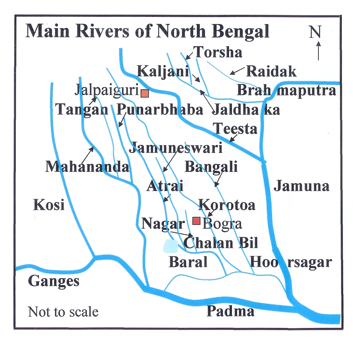
map_size =
map_caption =Karatoya River (also spelt Korotoa) ( _bn. করতোয়া নদী), a small stream in
Rajshahi Division ofBangladesh , was once a large and sacred river. A channel of it presently flows by the ancient ruins ofMahasthangarh (or Pundranagara, ancient capital ofPundravardhana ) inBogra District . The "Karatoya mahatmya" bears testimony to its past greatness.Majumdar, Dr. R.C., "History of Ancient Bengal", First published 1971, Reprint 2005, p. 4, Tulshi Prakashani, Kolkata, ISBN 81-89118-01-3.] In the "Mahabharata " it is mentioned that a visit to the Karatoya after three days’ fast produces the same merit as an aswamedha (horse killing) sacrifice. [ Majumdar, Dr. R.C., p. 24] Another ancient city,Sravasti , may have been located on the banks of the Karatoya, north of Mahasthangarh. However, there is a controversy about the possible location of Sravasti. [ Majumdar, Dr. R.C., p. 429]Etymology
The name of the river is formed of two Bengali words "kar" (hand) and "toa" (water), signifying, in Hindu mythology, that the river was formed by the water which was poured on the hands of
Shiva , when he marriedParvati .cite web | url = http://banglapedia.org/ht/K_0086.HTM | title = Karatoya River| accessdate = 2007-11-10 | last = Chowdhury| first = Masud Hassan | work = Banglapedia | publisher = Asiatic Society of Bangladesh]Changes in the course of rivers
Great changes have taken place in the course of some of the rivers in
Bengal and the adjoining areas, during the period since 1500 AD. Although positive evidence is lacking, similar changes can be assumed in the remoter past. The Karatoya is one of the rivers that has changed over the years.The map ("right") shows the main rivers in North Bengal and adjoining areas. Not shown are numerous tributaries and distributaries, which connect the main rivers, and allow the main rivers to change course. Therefore, the river-system pattern undergoes continuous changes. Such changes have not been reflected in the map. Moreover, many of the rivers have local names for sections of the course, adding to the complexity of the river system.
Tectonic disturbances have broken up the Karatoya into four distinct parts. The northern part, called the Dinajpur-Karatoya, is the main source of the Atrai. It rises in a marsh in Baikanthapur in
Jalpaigur i district, but also receives water from underground streams. InKhansama "upazila" its name changes to Atrai. In a second section, the Dinajpur-Karatoya was connected with the Rangpur-Karatoya north of Khansama, but very little water now passes down that channel. The upper part of Rangpur-Karatoya originates in the Jalpaiguri district and is known as the Deonai-Jamuneshwari up to Gobindaganj "upazila". In a third section, the Jamuneshwari-Karatoya flows south-southeast to Gobindaganj "upazila", where the main stream turns east through theKatakhali and falls into theBangali River . The portion of the former river passing through Shibganj upazila is dry most of the year. It effectively separates the Rangpur-Karatoya from the Bogra-Karatoya, which flows south past Bogra town till it joins the Bangali to make Phuljhor river, which falls into the Hoorasagar. The fourth part, the Pabna-Karatoya, is a moribund river bed nearHandial . Various other channels are also pointed out as parts of the Old Karatoya.Teesta
The Teesta earlier ran due south from
Jalpaiguri in three channels, namely, the Karatoya to the east, the Punarbhaba in the west and the Atrai in the centre. The three channels possibly gave the name to the river as Trisrota (possessed of three streams) which has been shortened and corrupted to Teesta. Of these three the Punarbhaba joined the Mahananda. The Atrai passing through a vast marshy area known asChalan Beel joined the Karatoya and the united stream joined the Padma near Jafarganj. In the destructive floods of 1787, the Teesta forsook its old channel and rushing south-east it joined the Brahmaputra.In the "Siyar-al-Mutakhkhirin" it is recorded that the Karatoya was three times the size of the Ganges when Bakhtiyar Khilji invaded the northern parts of Bengal in 1115. In Ven den Brouck's map of Bengal, prepared in 1660, the Karatoya is shown as a large channel.Rennel made a survey between 1764 and 1777 and his maps are one of the earliest authentic maps of Bengal in existence. In these maps Teesta is shown as flowing through North Bengal in several branches – Punarbhaba, Atrai, Karatoya etc. All these streams combined lower down with the Mahananda, now the westernmost river in North Bengal, and taking the name of Hoorsagar finally discharged into the Ganges at Jafarganj, near modern Goalundo. The Hoorsagar river is still in existence being the combined outfall of the Baral, a spill channel of the Ganges, the Atrai, the Jamuna or Jamuneswari (not the main Jamuna through which the Brahmaputra now flows), and the Karatoya, but instead of falling into the Ganges, it falls into the main Jamuna, a few miles above its confluence with the Padma at Goalundo. [Majumdar, S.C., Chief Engineer, Bengal, "Rivers of the Bengal Delta", Government of Bengal, 1941, reproduced in "Rivers of Bengal", Vol I, 2001, p. 45, published by Education department, Government of West Bengal.]
Kosi
The Kosi (Kausiki), which now flows through the north-eastern
Bihar and joins the Ganges at a point much higher up thanRajmahal , originally ran eastward and fell into the Brahmaputra. The channel of the Kosi, therefore, must have been steadily shifting towards the west, right across the whole breadth of North Bengal. There was a time when the Kosi and the Mahananda joined the Karatoya and formed a sort of ethnic boundary between people living south of it and the Kochs and Kiratas living north of the river.References
ee also
Wikimedia Foundation. 2010.