- N postcode area
-
London N postcode area 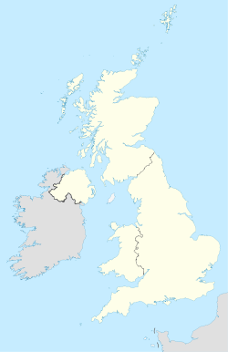
 N
NPostcode area N Postcode area name London N Post towns 1 Postcode districts 23 Postcode sectors 89 Postcodes (live) 17,827 Postcodes (total) 25,456 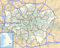 Locations in Greater London
Statistics as at October 2006 [1] The N (Northern) postcode area, also known as the London N postcode area,[2] is the part of the London post town covering part of North London, England.
It includes areas in the London boroughs of Hackney, Islington, Camden, Barnet, Haringey and Enfield. The N postcode area does not cover all of North London however. For example, parts of the London Borough of Enfield and the London Borough of Barnet are covered by the EN postcode area, and parts of the London Borough of Barnet, the London Borough of Harrow, the London Borough of Brent and the London Borough of Camden are covered by the HA postcode area or the NW postcode area.
Contents
Postal administration
The postcode area originated in 1857 as the N district of London. In 1917 it was subdivided into 22 numbered districts.[3] The Northern head district was designated as N1 and the rest of the numbering followed the alphabetical order of the other districts' main names. Most districts include local areas known by their own specific names (see table below). The official post town for all N postcodes is LONDON; district names do not form an essential part of postal addresses.[2] N81 is a non-geographic postcode district.[4]
List of postcode districts
The approximate coverage of the postcode districts, with the historic postal district names shown in italics:[5]
Postcode district Post town Coverage Local authority area N1 LONDON Northern head district: Barnsbury (part), Canonbury, Kings Cross, Islington, Pentonville, De Beauvoir Town, Hoxton Hackney, Islington, Camden N2 LONDON East Finchley district: East Finchley, Fortis Green, Hampstead Garden Suburb (part) Barnet, Haringey N3 LONDON Finchley district: Finchley, Church End, Finchley Central Barnet N4 LONDON Finsbury Park district: Finsbury Park, Manor House, Harringay (part), Stroud Green (part) Haringey, Islington, Hackney N5 LONDON Highbury district: Highbury, Highbury Fields Islington, Hackney (part) N6 LONDON Highgate district: Highgate, Hampstead Heath (part) Camden, Haringey, Islington N7 LONDON Holloway district: Holloway, Barnsbury (part), Islington (part), Tufnell Park (part) Islington, Camden N8 LONDON Hornsey district: Hornsey, Crouch End, Harringay (part) Haringey, Islington N9 LONDON Lower Edmonton district: Lower Edmonton, Edmonton (part) Enfield N10 LONDON Muswell Hill district: Muswell Hill Haringey, Barnet N11 LONDON New Southgate district: New Southgate, Friern Barnet, Bounds Green, Arnos Grove (part) Enfield, Barnet, Haringey N12 LONDON North Finchley district: North Finchley, Woodside Park Barnet N13 LONDON Palmers Green district: Palmers Green Enfield N14 LONDON Southgate district: Southgate, Oakwood, Arnos Grove (part) Enfield, Barnet N15 LONDON South Tottenham district: South Tottenham, Harringay (part), West Green, Seven Sisters, Stamford Hill (part) Hackney, Haringey N16 LONDON Stoke Newington district: Stoke Newington, Stamford Hill (part), Shacklewell, Dalston (part), Newington Green (part) Hackney N17 LONDON Tottenham district: Tottenham, South Tottenham (part) Haringey N18 LONDON Upper Edmonton district: Upper Edmonton, Edmonton (part) Enfield N19 LONDON Upper Holloway district: Upper Holloway, Archway, Tufnell Park (part), Hornsey (part) Islington, Camden N20 LONDON Whetstone district: Whetstone, Totteridge, Oakleigh Park Barnet N21 LONDON Winchmore Hill district: Winchmore Hill, Bush Hill, Grange Park Enfield N22 LONDON Wood Green district: Wood Green, Bounds Green (part), Bowes Park Haringey, Enfield N81 LONDON Non-geographic postcode district (Electoral Reform Services, located in N8) Haringey Boundaries
Postcode district N1 is central to London, with the N2–N20 postcode districts radiating outwards to the north. The postcode area is roughly bounded by the River Lea to the east and the Inner Ring Road to the south. In the west the boundary cuts through Hampstead Heath and follows the North Circular Road and Dollis Brook for short distances. The northern boundary cuts through several open spaces and follows the A110 road for a short distance. The postcode area maps to the London Borough of Haringey, most of the London Borough of Islington, the northwestern section of the London Borough of Hackney, southeastern parts of the London Borough of Barnet, southern sections of the London Borough of Enfield, and small parts of the London Borough of Camden.
Adjacent areas
Adjacent postcode areas EN 
NW  N
N 
E 
WC EC Clockwise from the east, the adjacent postcode areas are: E (London E), EC (London EC), WC (London WC), NW (London NW), EN (Enfield).
See also
References
- ^ "National Statistics Postcode Directory" (PDF). Office for National Statistics Postcode Directory (November 2006). Office for National Statistics. November 2006. http://www.statistics.gov.uk/geography/downloads/NSPDVersionNotes.pdf. Retrieved 2009-05-29.
- ^ a b Royal Mail (2004). Address Management Guide (4 ed.). Royal Mail Group.
- ^ "Postcodes". Archive Information Sheet. The British Postal Museum and Archive. http://www.postalheritage.org.uk/history/downloads/BPMA_Info_Sheet_Postcodes_web.pdf. Retrieved 24 March 2010.
- ^ "Royal Mail non-geographic postcodes". Royal Mail. 2007-03-07. ftp://ftp.royalmail.com/Downloads/public/ctf/rm/07mar_Current_Non_Geo.pdf. Retrieved 2008-03-10.
- ^ "Names of Streets and Places in the London Postal area". HMSO. 1930. http://www.londonancestor.com/po/1map-w.htm.
External links
- "N1". The Postcodes Project. Museum of London. http://www.museumoflondon.org.uk/postcodes/places/N1.html.
- "N2". The Postcodes Project. Museum of London. http://www.museumoflondon.org.uk/postcodes/places/N2.html.
- "N3". The Postcodes Project. Museum of London. http://www.museumoflondon.org.uk/postcodes/places/N3.html.
- "N4". The Postcodes Project. Museum of London. http://www.museumoflondon.org.uk/postcodes/places/N4.html.
- "N5". The Postcodes Project. Museum of London. http://www.museumoflondon.org.uk/postcodes/places/N5.html.
- "N6". The Postcodes Project. Museum of London. http://www.museumoflondon.org.uk/postcodes/places/N6.html.
- "N7". The Postcodes Project. Museum of London. http://www.museumoflondon.org.uk/postcodes/places/N7.html.
- "N8". The Postcodes Project. Museum of London. http://www.museumoflondon.org.uk/postcodes/places/N8.html.
- "N9". The Postcodes Project. Museum of London. http://www.museumoflondon.org.uk/postcodes/places/N9.html.
- "N10". The Postcodes Project. Museum of London. http://www.museumoflondon.org.uk/postcodes/places/N10.html.
- "N11". The Postcodes Project. Museum of London. http://www.museumoflondon.org.uk/postcodes/places/N11.html.
- "N12". The Postcodes Project. Museum of London. http://www.museumoflondon.org.uk/postcodes/places/N12.html.
- "N13". The Postcodes Project. Museum of London. http://www.museumoflondon.org.uk/postcodes/places/N13.html.
- "N14". The Postcodes Project. Museum of London. http://www.museumoflondon.org.uk/postcodes/places/N14.html.
- "N15". The Postcodes Project. Museum of London. http://www.museumoflondon.org.uk/postcodes/places/N15.html.
- "N16". The Postcodes Project. Museum of London. http://www.museumoflondon.org.uk/postcodes/places/N16.html.
- "N17". The Postcodes Project. Museum of London. http://www.museumoflondon.org.uk/postcodes/places/N17.html.
- "N18". The Postcodes Project. Museum of London. http://www.museumoflondon.org.uk/postcodes/places/N18.html.
- "N19". The Postcodes Project. Museum of London. http://www.museumoflondon.org.uk/postcodes/places/N19.html.
- "N20". The Postcodes Project. Museum of London. http://www.museumoflondon.org.uk/postcodes/places/N20.html.
- "N21". The Postcodes Project. Museum of London. http://www.museumoflondon.org.uk/postcodes/places/N21.html.
- "N22". The Postcodes Project. Museum of London. http://www.museumoflondon.org.uk/postcodes/places/N22.html.
Postcode areas in the United Kingdom, Channel Islands and Isle of Man AB AL B BA BB BD BH BL BN BR BS BT BX CA CB CF CH CM CO CR CT CV CW DA DD DE DG DH DL DN DT DY E EC EH EN EX FK FY G GIR GL GU GY HA HD HG HP HR HS HU HX IG IM IP IV JE KA KT KW KY L LA LD LE LL LN LS LU M ME MK ML N NE NG NN NP NR NW OL OX PA PE PH PL PO PR RG RH RM S SA SE SG SK SL SM SN SO SP SR SS ST SW SY TA TD TF TN TQ TR TS TW UB W WA WC WD WF WN WR WS WV YO ZE
Postcode areas in London London postal district Outer areas Categories:- Postcode areas covering London
- Media and communications in Hackney
- Media and communications in Islington
- Media and communications in Haringey
- Media and communications in Enfield
- Media and communications in Barnet


Wikimedia Foundation. 2010.