- Crouch End
-
Coordinates: 51°34′47″N 0°07′25″W / 51.579712°N 0.123729°W
Crouch End 
 Crouch End
Crouch End shown within Greater LondonOS grid reference TQ295885 London borough Haringey Ceremonial county Greater London Region London Country England Sovereign state United Kingdom Post town LONDON Postcode district N8 Dialling code 020 Police Metropolitan Fire London Ambulance London EU Parliament London UK Parliament Hornsey & Wood Green London Assembly Enfield and Haringey List of places: UK • England • London Crouch End is an area of north London, in the London Borough of Haringey.
Contents
Location
Crouch End is in a valley between Harringay to the east, Hornsey, Muswell Hill and Wood Green to the north, Finsbury Park and Archway to the south and Highgate to the west. Crouch End - the prosaic name is said to come from the Latin 'crux', a cross or crossroads, plus 'End', as it is at the eastern end of a valley. Where the clock tower is was once a local house called Crouch Hall.
To the immediate west, it is bounded by Highgate Wood, and the adjacent Queen's Wood, as well as a large expanse of playing fields. To the north is Alexandra Park and to the south Finsbury Park. The Parkland Walk, a former railway line, connects these two parks. Other parks in the area include Stationers' Park, Priory Park and Crouch Hill Park.
History
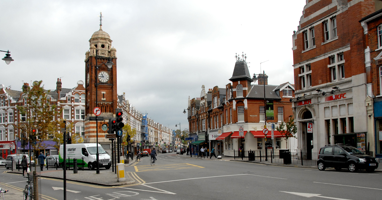
 Crouch End Broadway, looking north. Park Road branches to the left and Tottenham Lane to the right.
Crouch End grew up as a hamlet on the old medieval route from London to the north. At this time it was governed as part of Hornsey which became a parish in around 1300. This heavily-wooded area contained farms and villas, one of which was Crouch Hall, probably built in 1681 at the crossroads of what came to be known as Crouch End.[citation needed]
Crouch End remained rural until around 1880, probably because of the lack of adequate sewerage[citation needed]. Large parts remained in private ownership, inhibiting development. However, the development of the railway changed the area significantly. By 1887 there were seven railway stations in the area. Crouch End became a prosperous middle-class suburb due to an influx of mainly clerical workers who could easily commute to the city. The large old houses were replaced by comfortable middle-class housing and public parks were opened and a number of new roads and avenues, such as Elder Avenue and Weston Park were laid out.
It expanded greatly in the late Victorian period and most of its present-day streets were built up in the late 19th century.
By the mid-1930s Crouch End had a popular shopping centre that included an Opera House in the middle of Topsfield Parade.
Until 1965 it was administratively part of the Municipal Borough of Hornsey and that body's forerunners. In 1965, when local government in London was reorganised, Hornsey merged with the boroughs of Wood Green and Tottenham and Crouch End became part of the London Borough of Haringey.
In the post war years Crouch End gained a more mixed social grouping[citation needed] and the London-wide provision of social housing saw the growth of council homes in and around Crouch End into Hornsey Vale (known as Abyssinia) and Hornsey itself. Many of the houses in the area lay empty post-war and many were bought cheaply by speculative landlords who then let them out to the growing student populations of the Mountview and Hornsey Art Colleges. The area became known as a student bedsit land for several decades into the early 80's until gentrification of the area changed the social profile[citation needed] and it became progressively more middle class. Eventually many houses became so highly priced that the working class became slowly marginalised and their children unable to afford to live in the area moved away[citation needed]. These social changes could be seen by the changes in the shop types over the period[citation needed]; gentrification brought estate agents en masse until the pace slowed and this was replaced by up-market establishments and pavement-type cafes.
Notable buildings
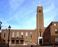 Hornsey Town Hall is in the centre of Crouch End
Among its more prominent buildings is the strikingly modernistic Hornsey Town Hall, built by the Municipal Borough of Hornsey as their seat of government in 1933-5. The architect was the New Zealand-born Reginald Uren. The interior and exterior have been used several times as a location by the BBC soap Eastenders. The centre of Crouch End is dominated by a red-brick clock-tower, built as a memorial to Henry Reader Williams[1] in 1895.
Education
For details of education in Crouch End see the London Borough of Haringey article.
There are three secondary schools serving the N8 Crouch End area. Highgate Wood School in Montenotte Road is a nine form entry mixed school with Performing Arts Status reflecting the area's long association with the performing arts. Highgate Wood School was the senior school to the former Crouch End School based on the corner of Wolseley Road and Park Road, opposite the Maynard Arms. Hornsey School for Girls in Inderwick Road is the only single sex school in N8. In Hornsey, there is the Greig City Academy (formerly St David and St Katherines). Haringey Council are also building a new secondary school in the nearby regeneration 'Heartlands' on the former gas works land off Hornsey Park Road which opened in 2011.
There are a number of primary schools in Crouch End and seven in total within the N8 postcode. These include Weston Park, Haringey's newest primary school and Rokesly School. There are several schools on the edges of Crouch End, these include, Coleridge at the top of Crouch End Hill (bordering Islington), St Aidans in Stroud Green (not N8), St Gildas and St Peter-in Chains, Oakington Way, St Mary's in Hornsey. Campsbourne Primary School on Nightingale Lane, North Harringay Primary School on Falkland Road and Ashmount Primary School. Ashmount is at present ( November 2011) on the south side of Hornsey Lane and so is in the N19 postal district and like Coleridge School on the border between Haringey and Islington, but in this case, in Islington. The school is scheduled to move in October 2012 to a new building at Crouch Hill Park which is adjacent to the Parkland Walk and in N8.
Local arts scene
Music
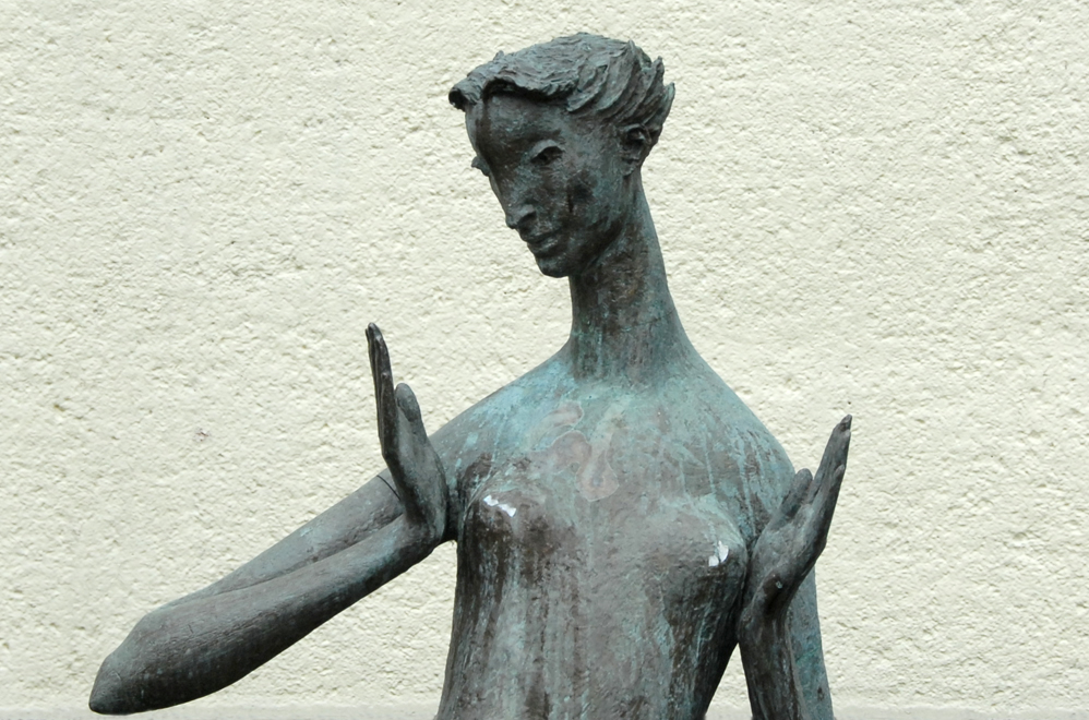
 'Reclining figure in Bronze' sculpture dating from 1964 by Thomas Bayliss Huxley-Jones outside Hornsey Library in Crouch End
A recording studio called KONK was established on Tottenham Lane in nearby Hornsey by Ray Davies, the Muswell Hill-born leader of The Kinks. Later, in the 1990's Dave Stewart of the Eurythmics set up a recording studio in the old church on Crouch End Hill (later sold to David Gray) called The Church. In the early 1980's The Church was owned by Bob Bura and John John Hardwick, the animators who worked on Camberwick Green, Captain Pugwash and Trumpton, who had converted part of it as a studio and later rented space to Dave Stewart and Annie Lennox. Previously, they had rehearsed (and worked) in the local record shop the Spanish Moon (now Elysian Fields).
Today Crouch End is home to Crouch End Festival Chorus, a leading symphonic chorus which has recorded with Lesley Garrett, Bryn Terfel, Ray Davies, Alfie Boe, EMI Classics and Classic FM as well as singing on the soundtrack for Doctor Who. They perform four concerts a year and also undertake other professional engagements for concerts and recordings.
Creativity
Crouch End has always been a popular area for creatives of all kinds. Recently established is the Crouch End Creatives community group, which has brought together many types of creatives within the Crouch End area and become a focus of activity. The group, originally a Facebook group is planning Crouch End's first Arts Festival in May 2012.
The Hornsey Town Hall, after many years of discussion, will soon be the new home of Mountview Academy of Theatre Arts. The listed building will also have exhibition space for local artists.
Hornsey Art School
In 1880 an Art School was established which in May 1968, as Hornsey College of Art, was the centre of a protest against the ideology of the school's teaching methods. The building has now been enlarged and converted to accommodate Coleridge Primary School, previously located on the opposite side of Crouch End Hill.
Arts scene urban legends
- According to legend, in the 1990s Dave Stewart of the Eurythmics invited Bob Dylan to drop in to his Crouch Hill recording studio any time he wanted to. It is said that Dylan took him up on his offer, but the taxi driver dropped him off on the adjacent Crouch End Hill. Dylan knocked on the door of the supposed home of Dave Stewart and asked for "Dave". By coincidence, the plumber who lived there was also called Dave. He was told that Dave was out, and would he like to wait and have some tea? Twenty minutes later the plumber returned and asked his wife whether there were any messages. "No", she said, "but Bob Dylan's in the living room having a cup of coffee".[2]
- Horror writer Stephen King is once supposed to have stayed at his friend, Peter Straub's house in Crouch End. The legend goes that after asking for a good place to go for a walk, he was directed towards the old railway line, now called the Parkland Walk. While here, he was inspired by the strange unsettling surroundings and the sculpture of a spriggan (a pan-like green man), which was pushing its way out of an old arched wall. King wrote the short story Crouch End, based on his visit to Crouch End, which was later adapted as an episode of Nightmares and Dreamscapes: From the Stories of Stephen King, which included the spriggan in the introduction.
- It is claimed that Stan Laurel and Oliver Hardy once performed at the music hall that is now Holmes Place/Virgin Gym and that they stayed at the Queen's Hotel.
Location for literature, film and television
There is a notable sense of pride among some Crouch End residents in its occasional use as a location for film, TV or literature. Examples include:
Literature
Film
Television (mainly using Hornsey Town Hall)
Notable residents
- See Category:People from Crouch End
Transport and local area
Nearest tube stations
Nearest railway stations
Bus services
Nearest places
See also
- Hornsey (parish) for the ecclesiastical and local government unit of which Crouch End was part from medieval times to 1867
- Municipal Borough of Hornsey for the local government unit of which Crouch End was part from 1903–1965
External links
References and notes
- ^ Henry Williams was a local wine-merchant and local councillor who led the campaign to preserve Highgate Wood against threatened development.[citation needed]
- ^ expectingrain.com
Categories:- Districts of Haringey
- Districts of London


Wikimedia Foundation. 2010.