- Municipal Borough of Hornsey
-
Hornsey 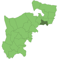
Hornsey within Middlesex in 1961Geography Status Local board 1867 – 1894
Urban district 1894 – 1903
Municipal borough From 19031901 area 2,875 acres (11.6 km2) 1965 area 2,871 acres (11.6 km2) HQ Town Hall, Crouch End From 1935 History Created 1867 Abolished 1965 Succeeded by London Borough of Haringey Demography 1901 population 72,056 1961 population 97,962 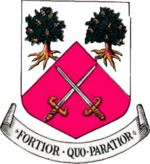
Coat of arms of the borough councilHornsey was a local government district in east Middlesex from 1867 to 1965.
In 1867, a Local Board was formed for part of the civil parish of Hornsey. The rest of the parish was already under South Hornsey Local Board formed in 1865.
In 1894, under the Local Government Act of that year, Hornsey became an urban district. In 1903, it was incorporated as a municipal borough. The corporation made two unsuccessful attempts to gain county borough status in 1904 and 1915.[1] The borough was part of the London postal district and Metropolitan Police District.
The borough's coat of arms, granted in 1904 featured two oak trees recalling the ancient forest that once covered the area and surviving remnants including Queen's Wood, Highgate Wood and Coldfall Wood. The manor of Hornsey had at one time been held by the Diocese of London and crossed swords, taken from the Diocese's arms, completed the design. The Latin motto was Fortior quo paratior or The better prepared, the stronger.
Hornsey Town Hall, built in 1933-5, was widely admired for its clean, modernist style and beautiful detailing, symbolizing enlightened local government. The architect was Reginald Harold Uren. However, since 2004 Haringey Council gradually removed municipal services from the building, and its increasing dereliction caused a local furore.
In 1965, the municipal borough was abolished and its area was transferred to Greater London under the London Government Act 1963. Hornsey's area was combined with the Municipal Borough of Tottenham and the Municipal Borough of Wood Green to form the present-day London Borough of Haringey.
References
- Local Government Act 1894
- London Government Act 1963
External links
Local government districts abolished or transferred by the London Government Act 1963 London · CC Battersea · Bermondsey · Bethnal Green · Camberwell · Chelsea · Deptford · Finsbury · Fulham · Greenwich · Hackney · Hammersmith · Hampstead · Holborn · Islington · Kensington · Lambeth · Lewisham · Paddington · Poplar · Shoreditch · Southwark · St. Marylebone · St. Pancras · Stepney · Stoke Newington · Wandsworth · Westminster · Woolwich
Constituent parts of Greater LondonEssex Barking · Chigwell (part) · Chingford · Dagenham · East Ham · Hornchurch · Ilford · Leyton · Romford · Walthamstow · Wanstead and Woodford · West Ham
Hertfordshire Middlesex · CC Acton · Brentford and Chiswick · Ealing · Edmonton · Enfield · Feltham · Finchley · Friern Barnet · Harrow · Hayes and Harlington · Hendon · Heston and Isleworth · Hornsey · Ruislip-Northwood · Southall · Southgate · Tottenham · Twickenham · Uxbridge · Wembley · Willesden · Wood Green · Yiewsley and West Drayton
Kent Surrey Transfers Coordinates: 51°34′44″N 0°7′22″W / 51.57889°N 0.12278°W
Categories:- Districts abolished by the London Government Act 1963
- Districts of England created by the Local Government Act 1894
- Local Government Districts created by the Local Government Act 1858
- History of Haringey
- History of local government in London (1889–1965)
- Municipal boroughs of England
- London geography stubs


Wikimedia Foundation. 2010.