- Crayford Urban District
-
Crayford Geography Status Urban district HQ Crayford History Created 1920 Abolished 1965 Succeeded by London Borough of Bexley 
Crayford was a local government district in north west Kent from 1920 to 1965 around the town of Crayford. As well as Crayford, it included Barnehurst, Barnes Cray and Slade Green.
It was created an urban district in 1920 from part of Dartford Rural District.
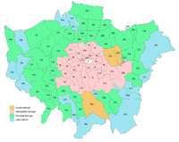
In 1965 it was abolished by the London Government Act 1963 and its former area transferred to Greater London from Kent. Its former area was combined with that of other districts to form the present-day London Borough of Bexley.
References
- London Government Act 1963
External links
Local government districts abolished or transferred by the London Government Act 1963 London · CC Battersea · Bermondsey · Bethnal Green · Camberwell · Chelsea · Deptford · Finsbury · Fulham · Greenwich · Hackney · Hammersmith · Hampstead · Holborn · Islington · Kensington · Lambeth · Lewisham · Paddington · Poplar · Shoreditch · Southwark · St. Marylebone · St. Pancras · Stepney · Stoke Newington · Wandsworth · Westminster · Woolwich
Constituent parts of Greater LondonEssex Barking · Chigwell (part) · Chingford · Dagenham · East Ham · Hornchurch · Ilford · Leyton · Romford · Walthamstow · Wanstead and Woodford · West Ham
Hertfordshire Middlesex · CC Acton · Brentford and Chiswick · Ealing · Edmonton · Enfield · Feltham · Finchley · Friern Barnet · Harrow · Hayes and Harlington · Hendon · Heston and Isleworth · Hornsey · Ruislip-Northwood · Southall · Southgate · Tottenham · Twickenham · Uxbridge · Wembley · Willesden · Wood Green · Yiewsley and West Drayton
Kent Surrey Transfers Coordinates: 51°27′N 0°11′E / 51.45°N 0.183°E
Categories:- Districts abolished by the London Government Act 1963
- History of Bexley
- History of local government in London (1889–1965)
- Urban districts of England
- London geography stubs

Wikimedia Foundation. 2010.