- Metropolitan Borough of St Marylebone
-
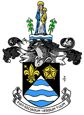
St Marylebone Motto: Fiat Secundum Verbum Tuum
(Be it according to Thy Word)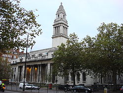
Marylebone Town Hall, Marylebone Road
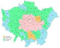
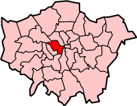
St Marylebone within the County of LondonGeography Status Metropolitan borough HQ Marylebone Road History Origin St Marylebone parish Created 1900 Abolished 1965 Succeeded by City of Westminster Politics Governance St Marylebone Borough Council 
Coat of arms of the borough councilThe Metropolitan Borough of St Marylebone was a Metropolitan borough of the County of London from 1900 to 1965. It was based directly on the previously existing civil parish of St Marylebone, which was incorporated into the Metropolitan Board of Works area in 1855, retaining a parish vestry, and then became part of the County of London in 1889.
It was that part of the current City of Westminster which is north of Oxford Street, and east of Maida Vale and Edgware Road. It included the areas Marylebone, Regent's Park, St John's Wood, and Lisson Grove, along with the western part of the district of Fitzrovia. In 1965 it was abolished and its former area was amalgamated with that of the Metropolitan Borough of Paddington and the Metropolitan Borough of Westminster to form the City of Westminster.
Contents
Origins and arms
The name is derived from a chapel, dedicated to St Mary, and founded by Barking Abbey, the holders of the Manor of Tyburn. The chapel was named St Mary-le-Bourne, for the bourne, or River Tyburn. In the borough's coat of arms, the blue and white waves represent this stream; the lily and rose, derived from Barking Abbey, represent the legend that when the Virgin's tomb was opened it was found to contain lilies and roses.
The motto: Fiat Secundum Verbatum Tuum, is from the Gospel of Luke Ch.I v.38 and translates as Be it according to Thy Word.[1]
The arms were granted by the College of Arms on 17 August 1901.[2]
Town hall
Following a competition in 1911, Sir Edwin Cooper was commissioned to design the town hall.[3] The building, in Marylebone Road was built 1914-20. The building is faced with Portland stone and is an example of Edwardian Graeco-Roman classicism, with a tower in the style of Christopher Wren and fluted columns. Cooper also designed the 1938-39 extension in a simpler style to house the public library.[4][5] The building in now Westminster Council House.
Area and population
The borough covered an area of 1,473 acres (6.0 km2). The population found in the Census was:
Civil Parish 1801-1899
Year[6] 1801 1811 1821 1831 1841 1851 1861 1871 1881 1891 Population 63,982 75,624 96,040 122,206 138,164 157,696 161,680 159,254 154,910 142,404 Metropolitan Borough 1900-1961
Year[7] 1901 1911 1921 1931 1941 1951 1961 Population 133,301 118,160 104,173 97,627 [8] 75,821 69,045 References
- ^ Civic Heraldry: The London County Council accessed 19 Jun 2007
- ^ Geoffrey Briggs, Civic & Corporate Heraldry, London, 1971
- ^ Alan Powers (2004). "Cooper, Sir (Thomas) Edwin (1874–1942)". Oxford Dictionary of National Biography. Oxford University Press. http://www.oxforddnb.com/view/article/32553. Retrieved 2008-06-29.
- ^ "Conservation Audit - Portman Estate". Westminster City Council. http://www3.westminster.gov.uk/docstores/publications_store/portman%20audit%20with%20cover.pdf. Retrieved 2008-06-29.
- ^ Nikolaus Pevsner, The Buildings of England - London except the Cities of London and Westminster, Harmondsworth, 1952
- ^ Statistical Abstract for London, 1901 (Vol. IV); Census tables for Metropolitan Borough of St Marylebone
- ^ St Marylebone MetB: Census Tables accessed 19 June 2007
- ^ The census was suspended for World War II
Local government districts abolished or transferred by the London Government Act 1963 London · CC Battersea · Bermondsey · Bethnal Green · Camberwell · Chelsea · Deptford · Finsbury · Fulham · Greenwich · Hackney · Hammersmith · Hampstead · Holborn · Islington · Kensington · Lambeth · Lewisham · Paddington · Poplar · Shoreditch · Southwark · St. Marylebone · St. Pancras · Stepney · Stoke Newington · Wandsworth · Westminster · Woolwich
Constituent parts of Greater LondonEssex Barking · Chigwell (part) · Chingford · Dagenham · East Ham · Hornchurch · Ilford · Leyton · Romford · Walthamstow · Wanstead and Woodford · West Ham
Hertfordshire Middlesex · CC Acton · Brentford and Chiswick · Ealing · Edmonton · Enfield · Feltham · Finchley · Friern Barnet · Harrow · Hayes and Harlington · Hendon · Heston and Isleworth · Hornsey · Ruislip-Northwood · Southall · Southgate · Tottenham · Twickenham · Uxbridge · Wembley · Willesden · Wood Green · Yiewsley and West Drayton
Kent Surrey Transfers History of the formation of the City of Westminster Metropolitan boroughs 
District boards Strand • WestminsterParishes Close of the Collegiate Church of St Peter • Liberty of the Rolls • Precinct of the Savoy • St Anne Within the Liberty of Westminster • St Clement Danes • St George Hanover Square • St Martin in the Fields • St Mary le Strand • St Paul Covent Garden • Westminster St James • Westminster St Margaret and St JohnOther Categories:- History of Westminster
- Metropolitan boroughs of the County of London
- 1900 establishments in the United Kingdom
- 1965 disestablishments


Wikimedia Foundation. 2010.