- Metropolitan Borough of Camberwell
-
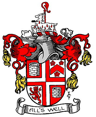
Camberwell Motto: All's well 
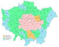
Camberwell within the County of LondonGeography Status Civil parish (until 1965)
Metropolitan borough (1900—1965)1911/1931 area 4,480 acres (18.1 km2)[1] 1961 area 4,482 acres (18.14 km2)[1] HQ Town Hall, Peckham Road History Origin Ancient parish Abolished 1965 Succeeded by London Borough of Southwark Demography 1911 population
- 1911 density261,328[1]
58/acre1931 population
- 1931 density251,294[1]
56/acre1961 population
- 1961 density175,304[1]
39/acrePolitics Governance Vestry of the Parish of Camberwell (1855—1900)
Camberwell Borough Council (1900—1965)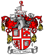
Coat of arms of the borough councilCamberwell was a civil parish and metropolitan borough in the County of London. The borough was created in 1900 by the London Government Act 1899, covering the area of the ancient parish of Camberwell. In 1965 it was amalgamated with the Metropolitan Borough of Southwark and the Metropolitan Borough of Bermondsey to form the London Borough of Southwark.
Contents
Settlements
It included the following places:
Coat of arms
The corporation was granted arms in 1901. The shield depicted the main areas of the borough. In the first and fourth quarter was a well, for Camberwell. The second quarter was for Dulwich: the chevron and cinquefoils from the arms of Edward Alleyn, founder of Dulwich College. The third quarter represented Peckham: the lion was from the arms of Robert, Earl of Gloucester, one time lord of the manor.
The crest depicted a wounded hart, symbol of St Giles, patron saint of Camberwell.
In 1927 the borough was additionally granted an heraldic badge and standard. The badge depicted a Camberwell Beauty butterfly.
Politics
From 1900 to 1934 the borough was controlled by the Municipal Reform Party (allied to the Conservatives). In 1934 the Labour Party gained control, which they retained until abolition in 1965.
For elections to Parliament, the borough was divided into three constituencies:
In 1918 the borough's representation was increased to four seats:
In 1950 the number of seats was halved to 2:
Area and population
The area of the borough was 4,480 acres (18.1 km2). The population, as recorded at the census, was:
Civil Parishes 1801-1899
Year[2] 1801 1811 1821 1831 1841 1851 1861 1871 1881 1891 Population 7,059 11,309 17,876 28,231 39,868 54,667 71,488 111,306 186,593 235,344 Metropolitan Borough 1900-1961
Year[3] 1901 1911 1921 1931 1941 1951 1961 Population 259,339 261,328 267,198 251,294 [4] 179,777 175,304 References
- ^ a b c d e Vision of Britain - Camberwell population (area and density)
- ^ Statistical Abstract for London, 1901 (Vol. IV); Census tables for Metropolitan Borough of Camberwell
- ^ Census Tables for the Metropolitan Borough of Camberwell accessed 14 Jun 2007
- ^ The census was suspended for World War II
Local government districts abolished or transferred by the London Government Act 1963 London · CC Battersea · Bermondsey · Bethnal Green · Camberwell · Chelsea · Deptford · Finsbury · Fulham · Greenwich · Hackney · Hammersmith · Hampstead · Holborn · Islington · Kensington · Lambeth · Lewisham · Paddington · Poplar · Shoreditch · Southwark · St. Marylebone · St. Pancras · Stepney · Stoke Newington · Wandsworth · Westminster · Woolwich
Constituent parts of Greater LondonEssex Barking · Chigwell (part) · Chingford · Dagenham · East Ham · Hornchurch · Ilford · Leyton · Romford · Walthamstow · Wanstead and Woodford · West Ham
Hertfordshire Middlesex · CC Acton · Brentford and Chiswick · Ealing · Edmonton · Enfield · Feltham · Finchley · Friern Barnet · Harrow · Hayes and Harlington · Hendon · Heston and Isleworth · Hornsey · Ruislip-Northwood · Southall · Southgate · Tottenham · Twickenham · Uxbridge · Wembley · Willesden · Wood Green · Yiewsley and West Drayton
Kent Surrey Transfers Metropolitan Board of Works Districts Fulham · Greenwich · Hackney · Holborn · Lee/Plumstead · Lewisham · Limehouse · Poplar · St Giles · St Olave · St Saviour's · Strand · Wandsworth · Westminster · Whitechapel
Headquarters at Spring GardensIncorporated vestries Battersea · Bermondsey · Bethnal Green · Camberwell · Chelsea · Clerkenwell · Fulham · Hackney · Hammersmith · Hampstead · Islington · Kensington · Lambeth · Mile End Old Town · Newington · Paddington · Plumstead · Rotherhithe · St George Hanover Square · St George in the East · St Luke Middlesex · St Martin in the Fields · St Marylebone · St Pancras · Stoke Newington · Shoreditch · Southwark St George the Martyr · Westminster St Margaret and St John · Westminster St James · WoolwichUndertakings Major works Legislation Royal Commission on the City of London · Metropolis Management Act 1855 · Metropolis Toll Bridges Act 1877 · Metropolitan Board of Works (Money) Act 1885 · Metropolis Management Amendment Act 1885 · Local Government Act 1888 · London Government Act 1899People Categories:- Metropolitan boroughs of the County of London
- History of Southwark
- Parishes governed by vestries (Metropolis)
- 1900 establishments in the United Kingdom
- 1965 disestablishments


Wikimedia Foundation. 2010.