- Metropolis Management Act 1855
-
The Metropolis Management Act 1855 
Parliament of the United KingdomLong title An Act for the better Local Management of the Metropolis. Statute book chapter 18 & 19 Vict. c.120 Territorial extent England and Wales Dates Royal Assent 14 August 1855 Commencement 12 December 1855 Other legislation Repealing legislation Statute Law Revision Act 1892, Public Health (London) Act 1936, Local Law (Greater London Council and Inner London Boroughs) Order 1965 Status: Repealed The Metropolis Management Act 1855 (18 & 19 Vict. c.120) was an act of the Parliament of the United Kingdom that created the Metropolitan Board of Works, a London-wide body to co-ordinate the construction of the city's infrastructure. The Act also created a second tier of local government consisting of parish vestries and district boards of works. The Metropolitan Board was the forerunner of the London County Council.
Contents
Background
The Royal Commission on the City of London considered the case for creation of an authority for the whole of London. Its report recommended the creation of a limited-function Metropolitan Board of Works and seven municipal corporations based on existing parliamentary representation.[1]
The Metropolitan board
The act constituted the Metropolitan Board of Works and provided that its members should be chosen by the parish vestries and district boards also constituted by the act. The first election of members was to take place on 12 December 1855. From 1857 one third of the board was to go out of office on the third Wednesday of June every year. The board was to take over the powers, duties and liabilities of the Metropolitan Commission of Sewers and the Metropolitan Buildings Office on 1 January 1856. Its area of responsibility was to be that designated by the Registrar General as London in the 1851 census.[2]
Vestries and District Boards
The second tier of local government was to be based on the existing vestries of civil parishes in an area comprising parts of the counties of Middlesex, Kent and Surrey. Section 42 of the Act dealt with the incorporation of vestries and district boards. Where single parishes became a local authority they were to have the title:
"The Vestry of the Parish of _______ in the County of ________"
Where parishes were grouped the resulting authority took the title:
"The Board of Works for the _________ District"
List of vestries, district boards and number of members elected to the metropolitan board
Vestries and districts of the Metropolis 1855 - City of London
- Bermondsey
- Bethnal Green
- Camberwell
- (and 5a) Chelsea
- Clerkenwell
- Fulham District
- Greenwich District
- Hackney District
- Hampstead
- Holborn District
- Islington
- Kensington
- Lambeth
- (and 15a) Lewisham District
- Limehouse District
- Mile End Old Town
- Newington
- Paddington
- Plumstead District
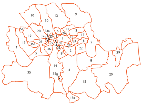
- Poplar District
- Rotherhithe
- St George Hanover Square
- St George in the East
- St Giles District
- St Luke
- St Martin the Fields
- St Marylebone
- St Olave District
- St Pancras
- St Saviours District
- Shoreditch
- Southwark St George the Martyr
- (and 34a) Strand District
- (and 35a) Wandsworth District
- (and 36a) Westminster District
- Westminster St James
- Whitechapel District
- Woolwich
The following were detached parts of parishes and districts:
5a Kensal Green; 15a Penge Hamlet; 34a St Anne; 35a detached portion of Streatham parish; 36a Kensington Palace
Not shown is Clerkenwell Detached, an exclave of that parish within Hornsey, Middlesex.
Electing Authority
Number of members elected to MBW
Administrative Headquarters
City of London 3 Guildhall Bermondsey Vestry (Surrey) 1 Town Hall, Spa Road, Bermondsey Bethnal Green Vestry (Middlesex) 1 Vestry Hall, Bethnal Green Camberwell Vestry (Surrey) 1 Vestry Hall, Peckham Road Chelsea Vestry (Middlesex) 1 Town Hall, King's Road, Chelsea St. James & St. John Clerkenwell Vestry (Middlesex) 1 Vestry Hall, 58 Rosomon Street, Clerkenwell (replaced by Town Hall in Rosebery Avenue 1895) Fulham District, comprising: 1 Town Hall, Walham Green Greenwich District , comprising: 1 141 Greenwich Road, Greenwich Hackney District, comprising: 1 Town Hall, Hackney Hampstead Vestry (Middlesex) 1 Vestry Hall, Haverstock Hill, Hampstead Holborn District, comprising: - Liberty of Glasshouse Yard (Middlesex)
- Liberty of Saffron Hill, Hatton Garden, Ely Rents and Ely Place (Middlesex)
- St Andrew Holborn Above the Bars with St George the Martyr (Middlesex)
- St Sepulchre (Middlesex)
1 Town Hall, Gray's Inn Road Islington St Mary Vestry (Middlesex) 2 Vestry Hall, Upper Street, Islington Kensington Vestry (Middlesex) 1 Town Hall, Kensington Lambeth Vestry (Surrey) 2 Vestry Hall, Kennington Green Lewisham District comprising: 1 member jointly with Plumstead District Catford Limehouse District comprising: 1 White Horse Street, Commercial Road Hamlet of Mile End Old Town Vestry (Middlesex) 1 Vestry Hall, Bancroft Road, Mile End Road Newington Vestry (Surrey) 1 Vestry Hall, Walworth Road Paddington Vestry (Middlesex) 1 Vestry Hall, Harrow Road Plumstead District comprising: 1 member jointly with Lewisham District Old Charlton Poplar District comprising: 1 117 High Street, Poplar Rotherhithe Vestry (Surrey) 1 member jointly with St Olave District Public Baths, Lower Road, Rotherhithe St George Hanover Square Vestry (Middlesex) 2 Vestry Hall, Mount Street, Grosvenor Square St George in the East Vestry (Middlesex) 1 Vestry Hall, Cable Street St Giles District comprising: 1 197 High Holborn St Luke Middlesex Vestry (Middlesex) 1 Vestry Hall, City Road St Martin in the Fields Vestry (Middlesex) 1 Town Hall, Charing Cross Road St Marylebone Vestry (Middlesex) 2 Court House, Marylebone Lane St Olave District comprising: 1 member jointly with Rotherhithe Vestry Vine Street, Tooley Street, Southwark St Pancras Vestry (Middlesex) 2 Vestry Hall, Pancras Road St Saviour's District comprising: - Southwark Christchurch (Surrey)
- Southwark St Saviour (Surrey)
1 3 Emerson Street, Bankside Shoreditch St Leonard Vestry (Middlesex) 2 Shoreditch Town Hall, Old Street Southwark St George the Martyr Vestry (Surrey) 1 Vestry Hall, 81 Borough Road Strand District comprising: 1 5 Tavistock Street Wandsworth District comprising: 1 East Hill, Wandsworth Westminster District comprising: - Westminster St Margaret and St John (Middlesex)
1 Town Hall, Caxton Street, Westminster Westminster St James Vestry (Middlesex) 1 Vestry Hall, Piccadilly Whitechapel District comprising: - Mile End New Town (Middlesex)
- Liberty of Norton Folgate (Middlesex)
- Old Artillery Ground (Middlesex)
- St Botolph without Aldgate (Middlesex)
- Spitalfields (Middlesex)
- Whitechapel (Middlesex)
1 15 Great Alie Street, Whitechapel Woolwich Vestry (Kent) 1 Town Hall, Woolwich A number of extra-parochial places lay within the Metropolitan Board's area but were not included in any District:
- Inner Temple
- Middle Temple
- Charterhouse
- Close of the Collegiate Church of St Peter (i.e. Westminster Abbey)
- Furnival's Inn
- Gray's Inn
- Lincoln's Inn
- Staple Inn
Changes in later legislation
In 1886 The Fulham district was dissolved and the two parish vestries of Fulham and Hammersmith became local authorities. Fulham vestry continued to use the existing town hall at Walham Green, while Hammersmith vestry built a town hall at Hammersmith Broadway.
In 1889 the Local Government Act replaced the Metropolitan Board of Works with the London County Council, and the area of the board became the County of London. From that date the various parishes were separated from Middlesex, Kent and Surrey and placed for all purposes in the new county, while the vestries and district boards continued to function under the aegis of the new county council.
In 1894 the Hackney District Board of Works was dissolved, with the vestries of Hackney and Stoke Newington assuming the powers of the district board. Stoke Newington vestry built a town hall at 126 Church Street. At the same time the Vestry of the Parish of Plumstead became a separate authority, with the remaining four parishes of Plumstead District being reconstituted as Lee District Board of Works.
In 1896 the parishes of Southwark St Olave and St Thomas were combined as a civil Parish.
In 1900 metropolitan boroughs created by the London Government Act replaced the vestries and district boards.
References
External links
- Official text of the Metropolis Managment Act 1855 as amended and in force today within the United Kingdom, from the UK Statute Law Database
- Official text of the Metropolis Managment Act 1855 as originally enacted within the United Kingdom, from the UK Statute Law Database
Metropolitan Board of Works Districts Fulham · Greenwich · Hackney · Holborn · Lee/Plumstead · Lewisham · Limehouse · Poplar · St Giles · St Olave · St Saviour's · Strand · Wandsworth · Westminster · Whitechapel
Headquarters at Spring GardensIncorporated vestries Battersea · Bermondsey · Bethnal Green · Camberwell · Chelsea · Clerkenwell · Fulham · Hackney · Hammersmith · Hampstead · Islington · Kensington · Lambeth · Mile End Old Town · Newington · Paddington · Plumstead · Rotherhithe · St George Hanover Square · St George in the East · St Luke Middlesex · St Martin in the Fields · St Marylebone · St Pancras · Stoke Newington · Shoreditch · Southwark St George the Martyr · Westminster St Margaret and St John · Westminster St James · WoolwichUndertakings Major works Legislation Royal Commission on the City of London · Metropolis Management Act 1855 · Metropolis Toll Bridges Act 1877 · Metropolitan Board of Works (Money) Act 1885 · Metropolis Management Amendment Act 1885 · Local Government Act 1888 · London Government Act 1899People  United Kingdom legislation
Pre-Parliamentary legislation 
Acts of Parliament by states preceding
the Kingdom of Great BritainActs of the Parliament of England to 1483 · 1485–1601 · 1603–1641 · Interregnum (1642–1660) · 1660–1699 · 1700–1706
Acts of the Parliament of Scotland
Acts of the Parliament of Ireland to 1700 · 1701–1800Acts of Parliament of the
Kingdom of Great Britain1707–1719 · 1720–1739 · 1740–1759 · 1760–1779 · 1780–1800
Acts of Parliament of the United Kingdom of
Great Britain and Ireland and the United
Kingdom of Great Britain and Northern IrelandChurch of England Measures Legislation of devolved institutions Acts of the Scottish Parliament
Acts and Measures of the Welsh Assembly
Acts of the Northern Ireland Assembly / of the Northern Ireland Parliament
Orders in Council for Northern IrelandSecondary legislation Categories:- 1855 in law
- United Kingdom Acts of Parliament 1855
- Local government legislation in England and Wales
- Local government of the metropolis (1855-1889)


Wikimedia Foundation. 2010.