- NW postcode area
-
London NW postcode area 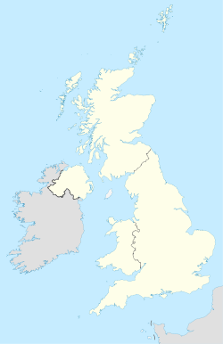
 NW
NWPostcode area NW Postcode area name London NW Post towns 1 Postcode districts 12 Postcode sectors 79 Postcodes (live) 14,677 Postcodes (total) 22,111 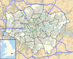 Locations in Greater London
Statistics as at October 2006 [1] The NW (North Western) postcode area, also known as the London NW postcode area[2], is a group of postcode districts covering part of northwest London, England. It is the successor of the NW sector, originally created as part of the London postcode district in 1856.
Contents
Postal administration
The London postal arrangements were refined in 1917 when the sub-districts (as appended to postal addresses) were given new alpha-numeric identities for public use;[3] the districts usually cover a wider area than their names might suggest. The district names are no longer included in the postal address because the first part of the postcode contains equivalent sorting information.[2]
List of postcode districts
The approximate coverage of the postcode districts, with the historic postal district names shown in italics:[4]
Postcode district Post town Coverage Local authority area NW1 LONDON North Western head district: Marylebone (part), Euston, Regent's Park, Camden Town, Somers Town, Primrose Hill (part), Gospel Oak (part) and Lisson Grove (part) Camden, Westminster NW2 LONDON Cricklewood district: Cricklewood, Willesden (part), Neasden (part), Dollis Hill, Childs Hill (most of) Barnet, Brent, Camden NW3 LONDON Hampstead district: Hampstead, Chalk Farm, Primrose Hill (part), Swiss Cottage, Belsize Park, Gospel Oak (part), Frognal, Childs Hill (a small part) Camden NW4 LONDON Hendon district: Hendon, Brent Cross Barnet NW5 LONDON Kentish Town district: Kentish Town, Tufnell Park (part), Dartmouth Park, Gospel Oak (part) Camden, Islington NW6 LONDON Kilburn district: Kilburn, Brondesbury, West Hampstead, Queen's Park Brent, Camden, Westminster NW7 LONDON Mill Hill district: Mill Hill, Arkley (part) Barnet NW8 LONDON St John's Wood district: St John's Wood, Primrose Hill (part), Lisson Grove (part) Camden, Westminster NW9 LONDON The Hyde district: The Hyde, Colindale, Kingsbury, Queensbury (part), West Hendon (part) Barnet, Brent, Harrow NW10 LONDON Willesden district: Willesden, Harlesden, Kensal Green, Stonebridge, Brent Park, Church End, Neasden (part), Acton (part), Park Royal (part), Brent, Ealing, Royal Borough of Kensington and Chelsea , Hammersmith and Fulham NW11 LONDON Golders Green district: Golders Green, Hampstead Garden Suburb (part) Barnet NW26 LONDON Non-geographic postcode district (located in NW1) Boundaries
Postcode district NW1 is central to London, with the NW2–11 postcode districts radiating outwards to the northwest. The boundaries of the area and its numbered districts have changed over time and are the result of the working requirements of Royal Mail. They are not tied to those of the local authority areas served; consequently a locality name might describe varying areas. The postcode area contains large parts of the London Borough of Barnet, London Borough of Brent and London Borough of Camden with small parts of the City of Westminster, the London Borough of Ealing, London Borough of Hammersmith and Fulham, London Borough of Harrow and London Borough of Islington. The NW7 district extends to the Greater London boundary with Hertfordshire and follows that boundary for a short distance near Scratch Wood.
Adjacent areas
Adjacent postcode areas WD EN 
HA  NW
NW 
N 
W WC EC Clockwise from the east, the adjacent postcode areas are: N (London N), EC (London EC), WC (London WC), W (London W), HA (Harrow), WD (Watford), EN (Enfield). The remainder of northwest London is covered by the HA, UB, part of the EN and a small section of WD postcode areas.
References
- ^ "National Statistics Postcode Directory" (PDF). Office for National Statistics Postcode Directory (November 2006). Office for National Statistics. November 2006. http://www.statistics.gov.uk/geography/downloads/NSPDVersionNotes.pdf. Retrieved 2009-05-29.
- ^ a b Royal Mail (2004). Address Management Guide (4 ed.). Royal Mail Group.
- ^ "Postcodes". Archive Information Sheet. The British Postal Museum and Archive. http://www.postalheritage.org.uk/history/downloads/BPMA_Info_Sheet_Postcodes_web.pdf. Retrieved 24 March 2010.
- ^ "Names of Streets and Places in the London Postal area". HMSO. 1930. http://www.londonancestor.com/po/1map-w.htm.
External links
- "NW1". The Postcodes Project. Museum of London. http://www.museumoflondon.org.uk/postcodes/places/NW1.html.
- "NW2". The Postcodes Project. Museum of London. http://www.museumoflondon.org.uk/postcodes/places/NW2.html.
- "NW3". The Postcodes Project. Museum of London. http://www.museumoflondon.org.uk/postcodes/places/NW3.html.
- "NW4". The Postcodes Project. Museum of London. http://www.museumoflondon.org.uk/postcodes/places/NW4.html.
- "NW5". The Postcodes Project. Museum of London. http://www.museumoflondon.org.uk/postcodes/places/NW5.html.
- "NW6". The Postcodes Project. Museum of London. http://www.museumoflondon.org.uk/postcodes/places/NW6.html.
- "NW7". The Postcodes Project. Museum of London. http://www.museumoflondon.org.uk/postcodes/places/NW7.html.
- "NW8". The Postcodes Project. Museum of London. http://www.museumoflondon.org.uk/postcodes/places/NW8.html.
- "NW9". The Postcodes Project. Museum of London. http://www.museumoflondon.org.uk/postcodes/places/NW9.html.
- "NW10". The Postcodes Project. Museum of London. http://www.museumoflondon.org.uk/postcodes/places/NW10.html.
- "NW11". The Postcodes Project. Museum of London. http://www.museumoflondon.org.uk/postcodes/places/NW11.html.
Postcode areas in the United Kingdom, Channel Islands and Isle of Man AB AL B BA BB BD BH BL BN BR BS BT BX CA CB CF CH CM CO CR CT CV CW DA DD DE DG DH DL DN DT DY E EC EH EN EX FK FY G GIR GL GU GY HA HD HG HP HR HS HU HX IG IM IP IV JE KA KT KW KY L LA LD LE LL LN LS LU M ME MK ML N NE NG NN NP NR NW OL OX PA PE PH PL PO PR RG RH RM S SA SE SG SK SL SM SN SO SP SR SS ST SW SY TA TD TF TN TQ TR TS TW UB W WA WC WD WF WN WR WS WV YO ZE
Related lists: Postal counties · Post towns · Postcode districts · London postal district Postcode areas in London London postal district Outer areas Categories:- Postcode areas covering London
- Media and communications in Brent
- Media and communications in Barnet
- Media and communications in Camden
- Media and communications in Westminster


Wikimedia Foundation. 2010.