- Massachusetts Route 79
-
Route 79

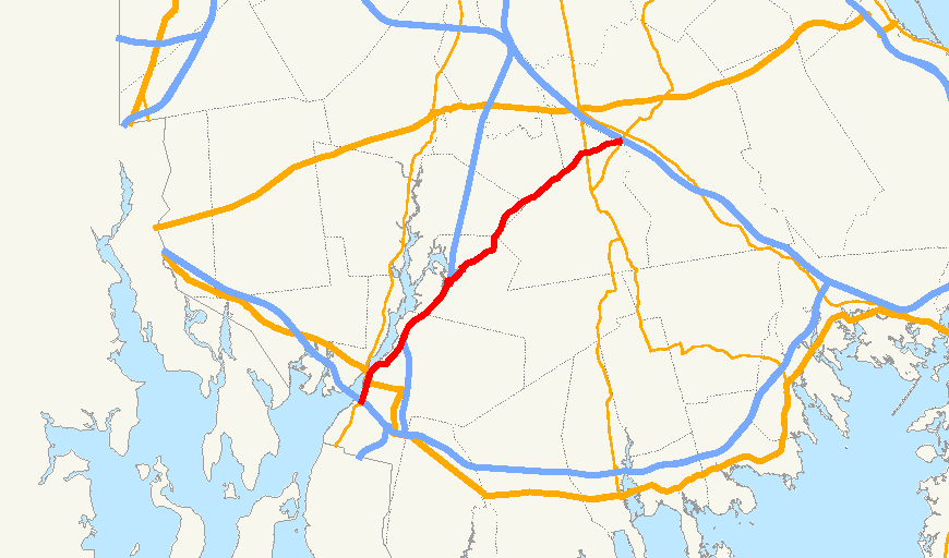
Route information Length: 18.47 mi[1] (29.72 km) Major junctions South end: 
 I-195/Route 138 in Fall River
 US 6 in Fall River
 Route 24 in Assonet
 Route 140 in Taunton
 Route 18 in Lakeville
North end:  Route 105 in Middleborough
Highway system Massachusetts State Highway Routes
←  Route 78
Route 80  →
→Route 79 is a highway in southeastern Massachusetts. The route begins as a highway in Fall River before becoming a rural route.
Route description
Route 79 begins as the Fall River Viaduct, a double-decked elevated highway that begins just south of the Braga Bridge, at the point where the road splits between ramps to Route 138 and I-195. The road continues northward under the Braga Bridge for a third of a mile before splitting into a single four-lane highway surface, elevated on embankments. It has two exits northbound and southbound to Davol Street, the road which travels in two one-way routes on either side of the highway, and also provides access to Route 6 between President Avenue and the Brightman Street Bridge, where that route and Route 138 cross the Taunton River. The Veterans Memorial Bridge, when completed, will connect to Route 79 just north of the Brightman Street Bridge; connections are in the process of being built.
The route continues northward, passing under North Main Street with exit access to that street. It then connects to Route 24 at that route's Exit 7. There is no access between Route 79 north and Route 24 south, or vice-versa. The route continues concurrently along Route 24 into the Assonet section of the town of Freetown, where it leaves its concurrency at Exit 9, turning on to South Main Street. (South Main Street southbound in Assonet connects to North Main Street in Fall River.) The route passes through the village before turning eastward along Elm Street, intertwining with the Assonet River as both make their way into Berkley.
In Berkley, Route 79 passes through the village of Myricks, in the far eastern end of the town. It crosses the Old Colony Railroad lines and County Road, the former alignment of Route 140, before crossing the current route at Exit 10 just over the Taunton line. In Taunton, the route follows along the Taunton-Lakeville town line before leaving Taunton completely. In Lakeville, the route heads through the northern part of the town, crossing Route 18 and passing the former Lakeville Hospital. Route 79 at Route 105 just over the Middleborough town line, just east of the junction of that route and I-495, and just west of the Middleborough/Lakeville MBTA station.
In 2013, following the completion of the Veterans Memorial Bridge project, the route's highway section will be repaved in Fall River. MassDOT is currently designing a $115 million project that will replace the Fall River Viaduct in the future.
Junction list
County Location Mile Roads intersected Notes Bristol Fall River 0.00 I-195 / Route 138Southern end of Route 79 begins. Concurrency begins with Route 138.
Southbound to I-195 or Route 138 South.0.3 Route 6 EastDavol Street – Northbound exit and southbound entrance only. 1.0 Route 6 West / Route 138 NorthNorthbound exit and southbound entrance only.
End of concurrency with Route 138.
To Brightman Street Bridge.1.6 Route 6 / Route 138 NorthSouthbound exit and northbound entrance only.
To Brightman Street Bridge.2.3 North Main Street Northbound exit and entrance. 2.6 North Main Street Southbound exit and entrance. 4.1 Route 24Beginning of concurrency with Route 24.
Southbound leaves Route 24 via Exit 7.
No access from 79 North to 24 South.Freetown 7.3 Route 24End of concurrency with Route 24 at Exit 9. Berkley 12.8 County Street Former intersection of Route 79 and Route 140. Taunton 13.1 Route 140Route 140 Exit 10. Plymouth Lakeville 16.9 Route 18Middleborough 18.48 Route 105Northern end of Route 79 at Route 105.
To I-495 via Route 105 north.
References
Freeways in the Providence metropolitan area Interstate highways Other freeways Unbuilt freeways See also Categories:- Numbered routes in Massachusetts
- Transportation in Plymouth County, Massachusetts

Wikimedia Foundation. 2010.