- Massachusetts Route 138
-
Route 138 
Route information Length: 43.58 mi[1] (70.14 km) Major junctions North end:  Route 28 in Milton
 Interstate 93/US 1 in Canton
 Interstate 495 in Raynham
 Interstate 195 in Fall River
South end:  RI Route 138 in Fall River
Highway system Massachusetts State Highway Routes
←  Route 137
Route 139  →
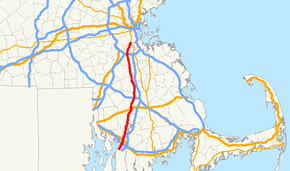
→Route 138 is a north–south state highway in Massachusetts. From Milton, Route 138 runs south through the following towns/cities:
- Canton (crossing Interstate 93/U.S. 1)
- Stoughton (crossing Route 27 and Route 139)
- Easton (crossing Route 123 and Route 106)
- Raynham (crossing Interstate 495)
- Taunton (crossing Route 140 and U.S. Route 44)
- Dighton
- Somerset (crossing U.S. Route 6 and Route 103)
- Fall River (crossing Route 79 and Interstate 195)
finally ending at the state line with Tiverton, Rhode Island, where it becomes Route 138 (Rhode Island).
During the Blizzard of 1978, Route 138's intersection with Interstate 93 (which at the time still had Route 128 concurrent with it) gained some notoriety as the location shot of photos taken featuring cars trapped in the snow along the underpassing freeway.[2]
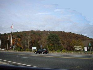
 Route 138 at the foot of Great Blue Hill
References
- ^ Executive Office of Transportation, Office of Transportation Planning - 2007 Road Inventory
- ^ http://www.mass.gov/?pageID=eopsterminal&L=3&L0=Home&L1=Public+Safety+Agencies&L2=Massachusetts+Emergency+Management+Agency&sid=Eeops&b=terminalcontent&f=mema_feature_story_2008_feature_stories_2008_blizzard_of_78_thirty_year_anniversary&csid=Eeops
Categories:- Numbered routes in Massachusetts
- Massachusetts road stubs
Wikimedia Foundation. 2010.

