- Compton Beauchamp
-
Coordinates: 51°35′06″N 1°35′56″W / 51.585°N 1.599°W
Compton Beauchamp 
 Compton Beauchamp
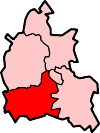
Compton Beauchamp shown within OxfordshirePopulation 50 (2001 census)[1] OS grid reference SU2887 District Vale of White Horse Shire county Oxfordshire Region South East Country England Sovereign state United Kingdom Postcode district SN6 Dialling code 01367 Police Thames Valley Fire Oxfordshire Ambulance South Central EU Parliament South East England UK Parliament Wantage List of places: UK • England • Oxfordshire Compton Beauchamp is a hamlet and civil parish 3 miles (4.8 km) southeast of Shrivenham in the Vale of White Horse. It was part of Berkshire until the 1974 boundary changes transferred it to Oxfordshire.
Contents
Location
The village is at the foot of the Berkshire Downs. The parish includes the hamlets of Knighton and Hardwell. Nearby is the Iron Age hill fort of Hardwell Castle.
History
Compton's toponym is derived from the Old English cum meaning "valley" and tun meaning "farm" or "settlement". Its manor was held by the Beauchamp family in the 13th century.
The moated Compton Beauchamp House was the home of the King's Councillor, Sir Thomas Fettiplace, from about 1507. His only daughter, Elizabeth, the wife of Sir Francis Englefield, had no children and the property passed to her Fettiplace cousins who took little interest in the property. In 1589 it was sold to an in-law, Sir Henry Poole. The old house had deteriorated and Poole appears to have pulled it down and replaced it with the present house in about 1600. Early in the 18th century a fashionable Palladian facade was attached to the eastern entrance front of this small Tudor manor house. The house was rented in the later 19th century by Vice-Chancellor Bacon and in 1940 by Singer sewing machine heiress Daisy Fellowes.
Parish church
The Church of England parish church of Saint Swithun is 13th century and is built of chalk.[2] The east window is a Decorated Gothic insertion and the north transept east window is early 14th century.[2] The font is a Perpendicular Gothic addition.[2] The painting on the chancel walls was executed by members of Vice-Chancellor Bacon's family, principally Lydia Lawrence [2].
The reredos, rood and altar rail were made by the artist Martin Travers[2] in the 1930s under the patronage of the banking heir and publisher, Samuel Gurney, who lived at the time in the Old Rectory.[citation needed]
References
- ^ "Area selected: Vale of White Horse (Non-Metropolitan District)". Neighbourhood Statistics: Full Dataset View. Office for National Statistics. http://neighbourhood.statistics.gov.uk/dissemination/viewFullDataset.do?instanceSelection=03070&productId=779&$ph=60_61&datasetInstanceId=3070&startColumn=1&numberOfColumns=4&containerAreaId=790499. Retrieved 30 March 2010.
- ^ a b c d e Pevsner, 1966, page 121
Sources & further reading
- Page, W.H.; Ditchfield, P.H., eds (1924). A History of the County of Berkshire, Volume 4. Victoria County History. pp. 523–528.
- Pevsner, Nikolaus (1966). Berkshire. The Buildings of England. Harmondsworth: Penguin Books. p. 121.
External links
Categories:- Villages in Oxfordshire
- Civil parishes in Oxfordshire
- Oxfordshire geography stubs

Wikimedia Foundation. 2010.