- Cumnor
-
Coordinates: 51°44′06″N 1°19′55″W / 51.735°N 1.332°W
Cumnor 
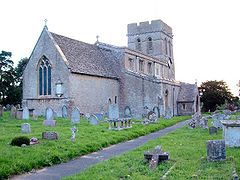
St. Michael's parish church
 Cumnor shown within Oxfordshire
Population 5,503 (parish, 2001 census)[1] OS grid reference SP4604 Parish Cumnor District Vale of White Horse Shire county Oxfordshire Region South East Country England Sovereign state United Kingdom Post town Oxford Postcode district OX2 Dialling code 01865 Police Thames Valley Fire Oxfordshire Ambulance South Central EU Parliament South East England UK Parliament Oxford West and Abingdon List of places: UK • England • Oxfordshire Cumnor is a village and civil parish 3.5 miles (5.6 km) west of the centre of Oxford, England. The parish of Cumnor includes Cumnor Hill, (a ribbon development between Cumnor village and Botley), Chawley (at the top of Cumnor Hill), the Dean Court area on the edge of Botley and the outlying settlements of Chilswell, Farmoor and Swinford. The parish was part of Berkshire until the 1974 local government boundary changes transferred it to Oxfordshire.
The village is about 2 miles (3.2 km) southwest of Botley and its centre is west of the A420 road to Swindon.
Contents
Amenities
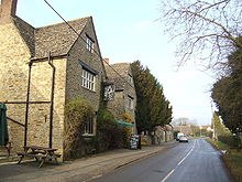
Cumnor has two public houses, the Vine and the Bear and Ragged Staff. It also has a newsagent, a butcher, a hairdresser and a post office/greengrocery. There are three churches: the Church of England parish church of Saint Michael in the centre of the village, Cumnor United Reformed Church in Leys Road and Living Stones Christian Fellowship that meets in the Primary School.
The village has football and cricket clubs, both located on Appleton Road.
Cumnor Primary School has produced many distinguished pupils who have attended schools such as Abingdon School, Magdalen College School, Oxford High School for Girls, Our Lady's Abingdon and the School of St Helen and St Katharine in Abingdon. The local county secondary school is Matthew Arnold School. Oxford School of Music is based in Cumnor Hill.
Notable residents, as of October 2008, included novelist Philip Pullman[2] and celebrity chef Sophie Grigson.[3]
History
Cumnor was first mentioned in 931 as Cumanoran. The name is of Old English origin, and appears to mean 'Hillside of a man named Cuma'.[4]
In Saxon and medieval times the parish was one of the largest in Berkshire, and included Wytham, Seacourt, North Hinksey, South Hinksey and Wootton.
In 1560 Cumnor Place was the scene of the death and suspected murder of Amy Robsart, the wife of Lord Robert Dudley. The house was pulled down in 1810, it is said because her ghost gave the locals so much trouble.
Cumnor is the basis for Lumsdon in Thomas Hardy's novel Jude The Obscure.
See also
- Henry Brooke, Baron Brooke of Cumnor (1903–1984)
- Ruth Deech, Baroness Deech of Cumnor (born 1943)
- Cumnor Hurst
References
- ^ "Area: Cumnor CP (Parish): Parish Headcounts". Neighbourhood Statistics. Office for National Statistics. http://www.neighbourhood.statistics.gov.uk/dissemination/LeadTableView.do?a=3&b=798723&c=Cumnor&d=16&e=15&g=481233&i=1001x1003x1004&m=0&r=1&s=1240682753323&enc=1&dsFamilyId=779. Retrieved 23 March 2010.
- ^ John Cornwell (24 October 2004). "Some enchanted author". Some enchanted author. The Times Online. http://www.timesonline.co.uk/tol/life_and_style/article494636.ece. Retrieved 6 January 2010.
- ^ Sophie Grigson (1 March 2007). "Sophie's Guide to the World of Vegetables". The Oxford Times "Weekend". http://www.oxfordtimes.co.uk/leisure/1227789.Sophie_s_guide_to_the_world_of_vegetables/. Retrieved 6 January 2010.
- ^ Mills & Room, 2003, page not cited
Sources & further reading
- Mills, A.D.; Room, A. (2003). A Dictionary of British Place-Names. Oxford: Oxford University Press. p. not stated. ISBN 0198527586.
- Page, W.H.; Ditchfield, P.H., eds (1924). A History of the County of Berkshire, Volume 4. Victoria County History. pp. 398–405.
- Pevsner, Nikolaus (1966). Berkshire. The Buildings of England. Harmondsworth: Penguin Books. pp. 124–126.
External links
- Cumnor Parish Record from the Bodleian Library, Oxford University
- Victoria County History of Berkshire
Towns 
Large Villages Blewbury • Cumnor (Chilswell, Cumnor Hill, Dean Court, Farmoor, Swinford) • Drayton • East Challow • East Hendred • Grove • Harwell • Kennington • Kingston Bagpuize with Southmoor (Kingston Bagpuize, Southmoor) • Marcham (Cothill) • Milton • North Hinksey (Botley, Harcourt Hill) • Radley • St. Helen Without (Dry Sandford, Shippon) • Shrivenham • Stanford in the Vale (Bow) • Steventon • Sunningwell (Bayworth, Boars Hill, Foxcombe Hill) • Sutton Courtenay • Watchfield • Wootton (Boars Hill, Henwood, Lamborough Hill)Other Civil
Parishes
(Component
Villages
and Hamlets)Appleford-on-Thames • Appleton-with-Eaton (Appleton, Eaton) • Ardington (Ardington Wick, West Ginge) • Ashbury (Idstone, Kingstone Winslow) • Baulking • Besselsleigh • Bourton • Buckland (Gainfield) • Buscot • Charney Bassett • Childrey • Chilton • Coleshill • Compton Beauchamp (Knighton) • Denchworth • East Hanney • Eaton Hastings • Fernham • Frilford • Fyfield and Tubney (Fyfield, Tubney, Netherton) • Garford • Goosey • Great Coxwell • Hatford (Little Hatford) • Hinton Waldrist (Duxford) • Kingston Lisle • Letcombe Bassett • Letcombe Regis • Little Coxwell • Littleworth • Lockinge (East Lockinge, West Lockinge) • Longcot • Longworth • Lyford • Pusey • Shellingford • South Hinksey (Hinksey Hill)• Sparsholt • Uffington • Upton • West Challow • West Hanney • West Hendred (East Ginge) • Woolstone • Wytham (Seacourt)Former Districts
and BoroughsMunicipal Borough of Abingdon • Abingdon Rural District • Faringdon Rural District • Wantage Urban District • Wantage Rural DistrictFormer
ConstituenciesCategories:- Villages in Oxfordshire
- Civil parishes in Oxfordshire
Wikimedia Foundation. 2010.


