- Rock of Gibraltar
-
Rock of Gibraltar 
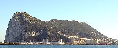
Western face of The Rock of Gibraltar, 2006.Elevation 426 m (1,398 ft) Prominence 426 m (1,398 ft) Location Location of the Rock of Gibraltar's summit.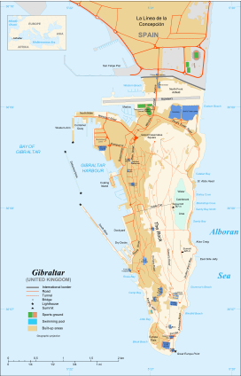

Location Gibraltar Range Betic Cordillera Coordinates 36°07′33″N 05°20′35″W / 36.12583°N 5.34306°WCoordinates: 36°07′33″N 05°20′35″W / 36.12583°N 5.34306°W Geology Age of rock Jurassic Climbing Easiest route Cable car, Road, Hike The Rock of Gibraltar (sometimes by its original Latin name, Calpe,[1] or from its later Arabic name: جبل طارق, or Jabal Tariq ("Rock of Tariq"), from which its English name is derived; Peñón de Gibraltar in Spanish) is a monolithic limestone promontory located in Gibraltar, off the southwestern tip of Europe on the Iberian Peninsula.[2] It is 426 m (1,398 ft) high. The Rock is Crown property of the United Kingdom, and borders Spain. The sovereignty of Gibraltar was transferred from Spain to the Kingdom of Great Britain by the Treaty of Utrecht in 1713 after the War of the Spanish Succession.[3] In 2002, the United Kingdom and Spain were working on "ending the centuries-old [sovereignty] dispute over the rock."[4] Most of the Rock's upper area is covered by a nature reserve, which is home to around 250 Barbary Macaques. These macaques, as well as a labyrinthine network of tunnels, attract a large number of tourists each year.
The Rock of Gibraltar was one of the Pillars of Hercules and was known to the Romans as Mons Calpe, the other pillar being Mons Abyla or Jebel Musa on the African side of the Strait. In ancient times the two points marked the limit to the known world, a myth originally fostered by the Phoenicians.[2][5]
Contents
Geology
The Rock of Gibraltar is a monolithic promontory. It is a deeply eroded and highly faulted limb of an overturned fold. The sedimentary strata comprising the Rock of Gibraltar are overturned (upside down) with the oldest strata overlying the youngest strata. These strata are the Catalan Bay Shale Formation (youngest), Gibraltar Limestone, Little Bay Shale Formation (oldest), and Dockyard Shale Formation (age unknown). These strata are noticeably faulted and deformed.[6]
The Catalan Bay Shale Formation consists predominately of shale. It also contains thick units composed of either brown calcareous sandstone; soft shaly sandstone interbedded with bluish-black limestone; and interlayered greenish-gray marls and dark gray cherts. The Catalan Bay Shale Formation contains unidentifiable echinoid spines and belemnite fragments and infrequent Early Jurassic (Middle Lias) ammonites.[6]
The Gibraltar Limestone consists of greyish-white or pale-gray compact, and sometime finely crystalline, medium to thick bedded limestones and dolomites that locally contain chert seams. This formation comprises about three quarters of the Rock of Gibraltar. Geologists have found various poorly preserved and badly eroded and rolled marine fossils within it. The fossils found in the Gibraltar Limestone include various brachiopods; corals; echinoid fragments; gastropods (including ammonites); pelecypods; and stromatolites. These fossils indicate an Early Jurassic age (Lower Lias) for the deposition of the Gibraltar Limestone.[6]
The Little Bay and Dockyard shale formations form a very minor part of the Rock of Gibraltar. The Little Bay Shale Formation consists of dark bluish-gray, unfossiliferous shale, which is interbedded with thin layers of grit, mudstone, and limestone. It predates the Gibraltar Limestone. The Dockyard Shale Formation is an undescribed varigated shale of unknown age that lies buried beneath the Gibraltar's dockyard and coastal protection structures.[6]
These geological formations were deposited during the early part of the Jurassic Period some 175-200 million years ago, when the African tectonic plate collided tightly with the Eurasian plate. The Mediterranean became a lake that, over the course of time, dried up during the Messinian salinity crisis. The Atlantic Ocean then broke through the Strait of Gibraltar, and the resultant flooding created the Mediterranean Sea. The Rock forms part of the Betic Cordillera, a mountain range that dominates south-eastern Iberia.[6]

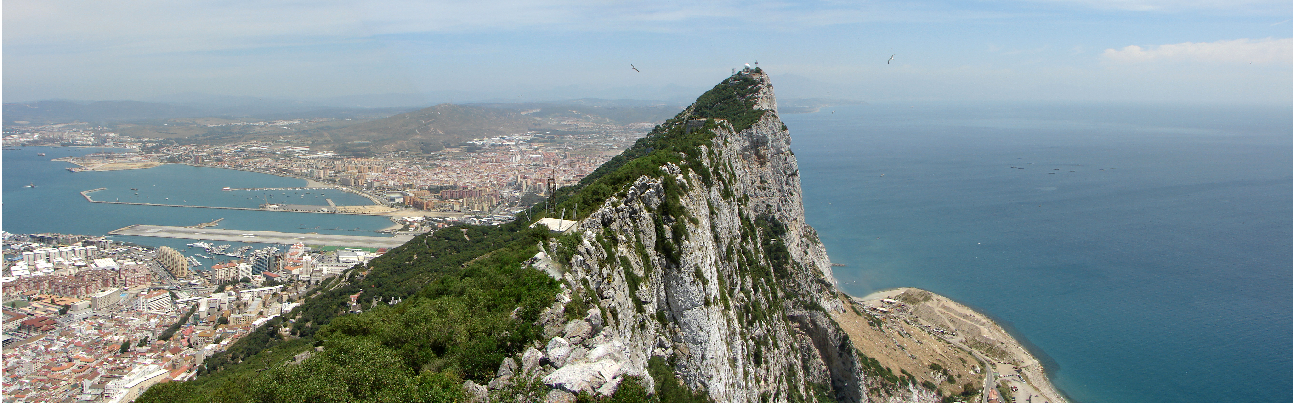
Today, the Rock of Gibraltar forms a peninsula jutting out into the Strait of Gibraltar from the southern coast of Spain. The promontory is linked to the continent by means of a sandy tombolo with a maximum elevation of 3 m (9.8 ft).[7] To the north, the Rock rises vertically from sea level up to 411.5 m (1,350 ft) at Rock Gun Battery. The Rock's highest point stands 426 m (1,398 ft) above the strait at O'Hara's Battery. The Rock's central peak, Signal Hill, stands at an elevation of 387 m (1,270 ft). The near-cliffs along the eastern side of the Rock drop down to a series of wind-blown sand slopes that date to the glaciations when sea levels were lower than today, and a sandy plain extended east from the base of the Rock. The western face, where the City of Gibraltar is located, is comparatively less steep.
 A panoramic view from the top of the Rock of Gibraltar looking north.
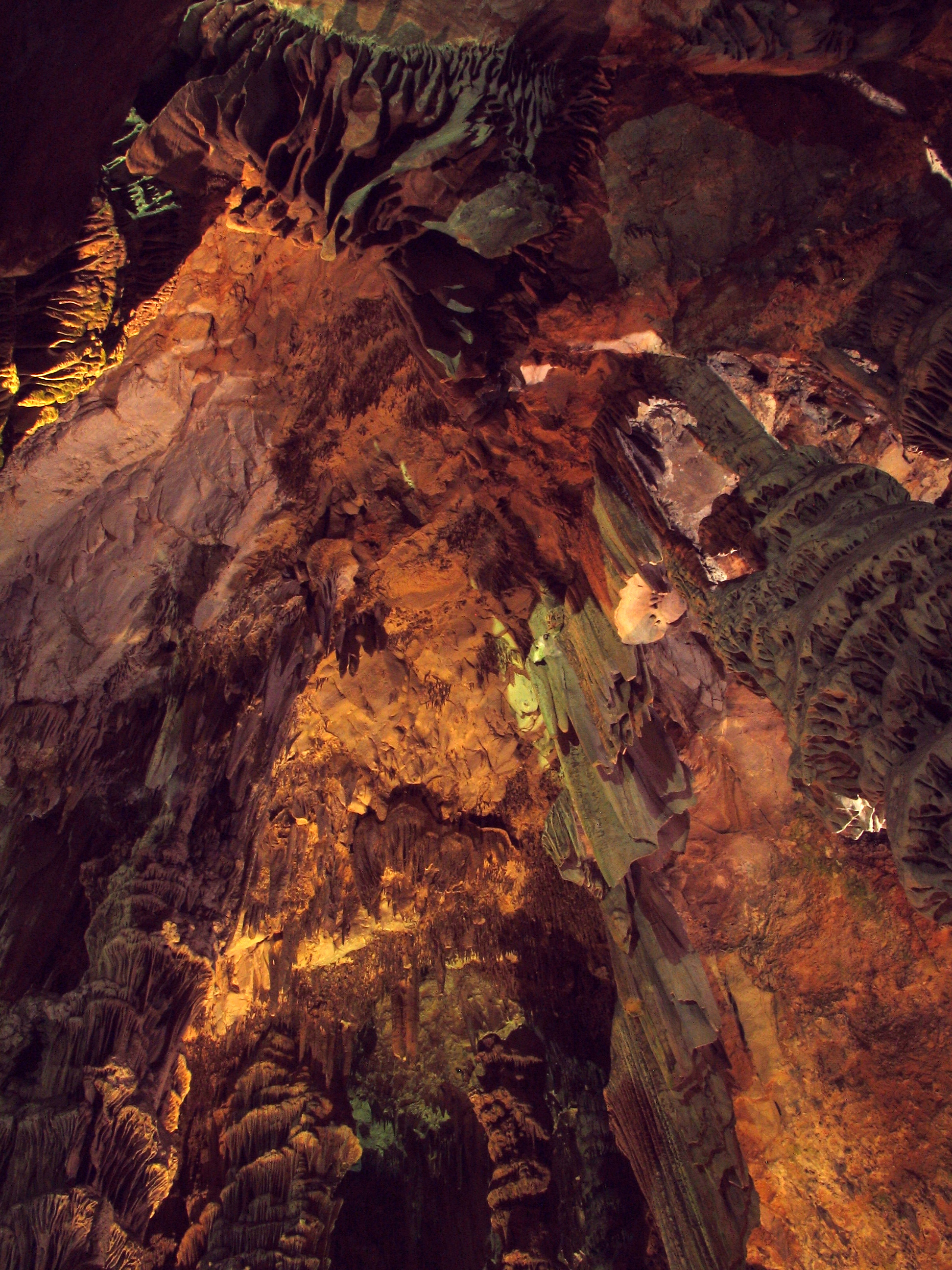
Calcite, the mineral that makes up limestone, dissolves slowly in rainwater. Over time, this process can form caves. For this reason the Rock of Gibraltar contains over 100 caves. St. Michael's Cave, located halfway up the western slope of the Rock, is the most prominent and is a popular tourist attraction.
Gorham's Cave is located near sea level on the steep eastern face of the Rock. It is noteworthy because archaeological excavations in the cave have found evidence that Neanderthals used it as far back as 30,000 years ago. It is especially significant because plant and animal remains found in the cave (and others nearby) indicate that the Neanderthals had a highly varied diet.[8]
Fortification

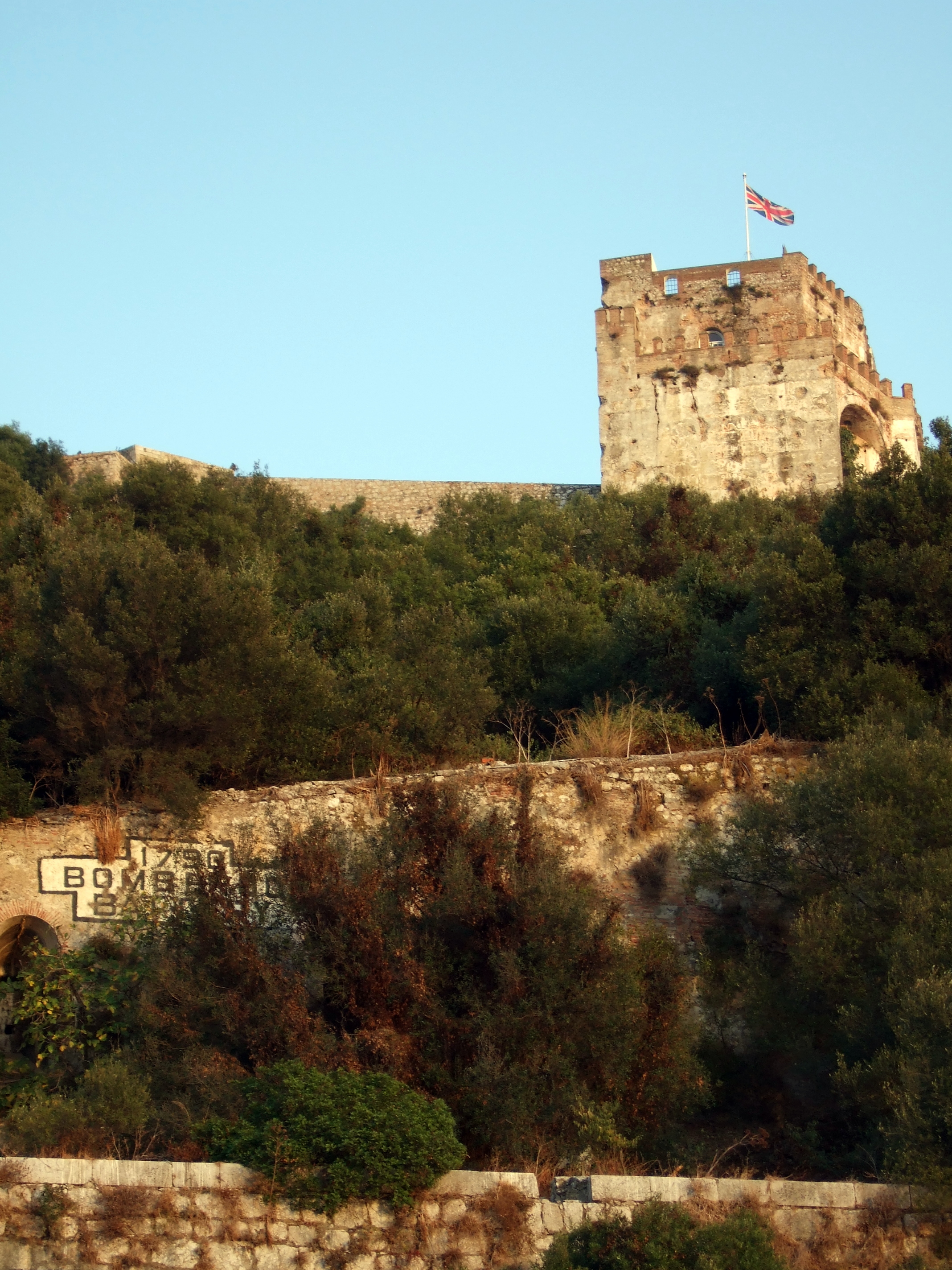
The Moorish Castle
The Moorish Castle is a relic of the Moorish occupation of Gibraltar, which lasted for 710 years. It was built in the year A.D. 711, when the Berber chieftain Tariq ibn-Ziyad first landed on the Rock that still bears his name.The 17th century Muslim historian Al-Maqqari wrote that upon landing, Tariq burned his ships.
The principal building that remains is the Tower of Homage, a massive building of brick and very hard concrete called tapia. The upper part of the tower housed the former occupants' living apartments and Moorish bath.
The Galleries
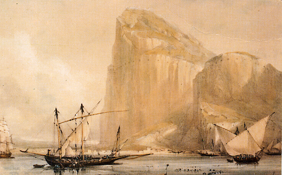
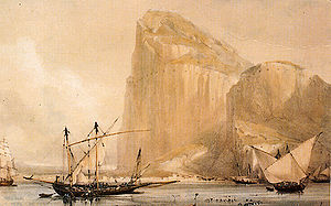 The Rock of Gibraltar's North Front cliff face from Bayside (c.1810) showing the embrasures in the Rock.
A unique feature of the Rock is its system of underground passages, known as the Galleries or the Great Siege Tunnels.
The first of these was dug towards the end of the four years’ siege which lasted from 1779-1783. General Elliot, afterwards Lord Heathfield, who commanded the garrison throughout the siege, was anxious to bring flanking fire on the Spanish batteries in the plain below the North face of the Rock. On the suggestion of Sergeant Ince of the Royal Engineers, he had a tunnel bored from a point above Willis’s Battery to communicate with the Notch, a natural projection from the North face. The plan was to mount a battery there. There was no intention at first of making embrasures in this tunnel, but an opening was found necessary for ventilation; as soon as it had been made a gun was mounted in it. By the end of the siege, the British had constructed six such embrasures, and mounted four guns.
The Galleries, which tourists may visit, were a later development of the same idea and were finished in 1797. They consist of a whole system of halls, embrasures, and passages, of a total length of nearly 304 m (997 ft). From them, one may see a series of unique views of the Bay of Gibraltar, the isthmus, and Spain.
The Second World War onwards
When World War II broke out in 1939, the authorities evacuated the civilian population to Morocco, the United Kingdom, Jamaica, and Madeira so that the military could fortify Gibraltar against a possible German attack. By 1942 there were over 30,000 British soldiers, sailors, and airmen on the Rock. They expanded the tunnel system and made the Rock a keystone in the defence of shipping routes to the Mediterranean.
In February 1997, it was revealed the British had a secret plan called Operation Tracer to conceal service men in tunnels beneath the Rock in case the Germans captured it. The team in the rock would have radio equipment with which to report enemy movements. A six-man team waited under cover at Gibraltar for two and half years. The Germans never got close to capturing the rock and so the men were never sealed inside. The team was disbanded to resume civilian life when the war ended.
Invincibility
Despite long sieges it seemed that there was nothing that could destroy the Rock or its people.[vague] This history has inspired the saying "solid as the Rock of Gibraltar", which is used to describe a person or situation that cannot be overcome and does not fail.[citation needed] The motto of the Royal Gibraltar Regiment and even Gibraltar itself, Nulli Expugnabilis Hosti (Latin for "No Enemy Shall Expel Us"), reflects this invincibility.
Upper Rock Nature Reserve
Upper Rock Nature Reserve 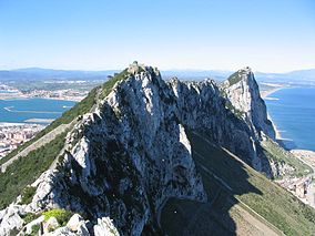
View north along the spine of the Rock of Gibraltar, within the nature reserve looking towards Spain.Location Rock of Gibraltar Nearest city Gibraltar Coordinates 36°08′43″N 05°20′35″W / 36.14528°N 5.34306°W Established 1993 Governing body Gibraltar Ornithological and Natural History Society Approximately 40% of Gibraltar's land area was declared a nature reserve in 1993.
Flora and fauna
See also: Gibraltar Barbary Macaques, List of mammals in Gibraltar, and List of reptiles and amphibians in Gibraltar
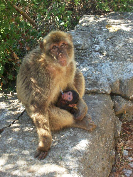
The flora and fauna of the Upper Rock Nature Reserve are of conservation interest and are protected by law.[9] Within it is a range of animals and plants, but the highlights are the Barbary Macaques (the famous Rock Apes), the Barbary Partridges, and flowers such as Gibraltar's own Chickweed, Thyme and the Gibraltar Candytuft.[citation needed] The Barbary Macaques may have originated from an escape of North African animals transported to Spain; it is also possible that the original Gibraltar macaques are a remnant of populations that are known to have spread throughout Southern Europe during the Pliocene, up to 5.5 million years ago.[10][11] Some animals of the Rock have been reintroduced by the Alameda Wildlife Conservation Park who have three Barbary Macaque.
Ornithology
The Rock of Gibraltar, at the head of the Strait, is a prominent headland, which accumulates migrating birds during the passage periods. The vegetation on the Rock, unique in southern Iberia, provides a temporary home for many species of migratory birds that stop to rest and feed before continuing migration for their crossing over the sea and desert. In spring, they return to replenish before continuing their journeys to Western Europe, journeys which may take them as far as Greenland or Russia.[12]
See also
- List of famous rocks
References
- ^ Alternate Names or Name Variants for Gibraltar
- ^ a b Welcome To The Rock of Gibraltar! by costarsure.com
- ^ Gibraltar, September 2001
- ^ Dispute, February 18, 2002
- ^ "Pillars of Hercules". The Gibraltar Museum. Archived from the original on 2007-07-20. http://web.archive.org/web/20070720172438/http://www.gib.gi/museum/phoenicians.htm. Retrieved 2008-01-14.
- ^ a b c d e Rose, E. P. F., and M. S. Rosenbaum, 1991, A Field Guide to the Geology of Gibraltar, The Gilbraltar Museum, Gibraltar. 192 pp.
- ^ "http://www.uhu.es/jr.vidal/pdf/journalsp/pdf08.pdf" (in Spanish). Boletín de la Sociedad Española de Espeleología y Ciencias del Karst: 7. 2002.
- ^ Earlham College - Physical Geology 2004 - The Rock of Gibraltar and Surroundings
- ^ GONHS - A Guide to The Upper Rock Nature Reserve
- ^ DNA solves mystery of Gibraltar’s macaques
- ^ C.Michael Hogan. 2008. Barbary Macaque: Macaca sylvanus, Globaltwitcher.com, ed. N.Strõmberg
- ^ Official Government of Gibraltar London Website
- "Gibraltar". Gibraltar: the Travel Key to the Mediterranean: 5–12. 1931.
Categories:- IUCN Category Ia
- Landforms of Gibraltar
- National symbols of Gibraltar
- Environment of Gibraltar
- Natural monoliths
- Naturalis Historia Encyclopedia
- Naturalis Historia Book 3: Europe Part 1
- The Living Daylights
- Baetic System


Wikimedia Foundation. 2010.