- Commissioners' Plan of 1811
-
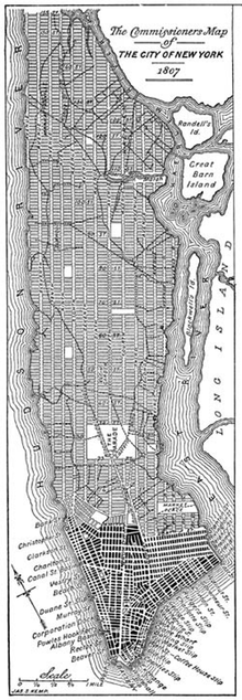 A modern redrawing of the 1807 version of the Commissioner's Grid plan for Manhattan, a few years before it was adopted in 1811.
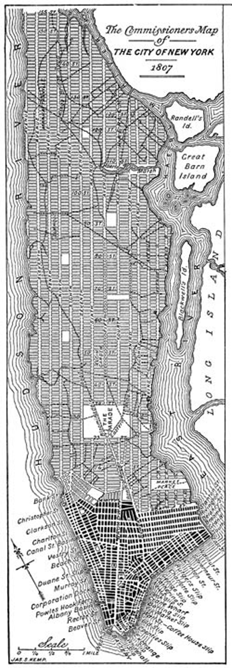
The Commissioners' Plan of 1811 was the original design plan for the streets of Manhattan, which put in place the grid plan that has defined Manhattan to this day.
It originated as a proposal by the New York State Legislature, adopted in 1811 for the orderly development and sale of the land of Manhattan between 14th Street and Washington Heights. The plan is arguably the most famous use of the grid plan and is considered by most historians to have been far-reaching and visionary. Since its earliest days, the plan has been criticized for its monotony and rigidity, in comparison with irregular street patterns of older cities, but in recent years has been viewed more favorably by urban planning critics.[1]
Central Park, the massive urban greenspace in Manhattan running from Eighth Avenue to Fifth Avenue and from 59th Street to 110th Street, is not a part of this plan, as Central Park was not envisioned until 1853. There were a few smaller interruptions in the grid, such as a park called the Parade between 23rd Street and 33rd Street.
Contents
Origins
Earlier street layouts for Manhattan had been drawn up prior to the Commissioners' Plan. In 1797, for example, the city asked Joseph Mangin and Casimir Goerck to survey Manhattan's streets; the two eventually produced a map which included a web of future streets, most of which appeared to correspond with future developers' speculative plans for street grids on their properties north of the city. Nevertheless, the scheme was pointedly rejected by the City Council.[2]
In 1807, however, the City Council showed a new willingness to consider planning for the city's future, and asked the state for help in laying out future streets. The council said its goal was "laying out Streets... in such a manner as to unite regularity and order with the public convenience and benefit and in particular to promote the health of the City...." In March 1807, the council appointed a three-member commission made up of Gouverneur Morris, the lawyer John Rutherfurd, and the surveyor Simeon De Witt, to establish a comprehensive street plan for Manhattan.[3]
A month later, the state legislature gave the commissioners "exclusive power to lay out streets, roads, and public squares, of such width, extent, and direction, as to them shall seem most conducive to public good, and to shut up, or direct to be shut up, any streets or parts thereof which have been heretofore laid out... [but] not accepted by the Common Council." The jurisdiction of the commission was all of Manhattan north of Houston Street, and into the Hudson and East Rivers 600 feet beyond the low water mark.[1][3]
Morris was named the president of the commission. The commissioners were paid $4 a day for their work, and were empowered to enter onto private property, and were greeted with widespread hostility from property owners. The commissioners' chief engineer and surveyor, John Randel, Jr., said afterwards that he "was arrested by the Sheriff, on numerous suits instituted...for trespass and damage by...workmen, in passing over grounds, cutting off branches of trees. &c., to make surveys under instructions from the Commissioners."[3]
The plan
The commissioners published their plan in March 1811 in the form of an eight-foot map with 12 main north-south avenues and numerous cross streets, with Broadway running at an angle through it. The goal was "a free and abundant circulation of air" to stave off disease. The right angles were also favored because "straight-sided and right-angled houses are the most cheap to build."[1][3]
The plan called for a regular grid of streets and property lines without regard to the topography of the island itself. The plan called for sixteen numbered and lettered avenues running north and south roughly parallel to the shore of the Hudson River. Except in the north and south ends of the island, the avenues would begin with First Avenue on the east side and run through Twelfth Avenue in the west. In addition, in a neighborhood that would come to be known as the East Village, nicknamed Alphabet City for obvious reasons, there would be four additional lettered avenues running from Avenue A eastward to Avenue D.
There would also be 155 orthogonal cross streets. The location of the cross streets was fixed at the boundaries of 5-acre (20,000 m2) parcels into which the land had previously been divided. The basepoint for the cross streets was First Street: this was a short and inconspicuous street, which still exists, and originally ran from the intersection of Avenue B and Houston Street to the intersection of the Bowery and Bleecker Street. Peretz Square, a small triangular sliver park where Houston Street, First Street and First Avenue meet marks the spot where the grid takes hold.[4]
Each avenue was to be one hundred feet (30 m) wide. The avenues in the center of the island were to be separated by 922 feet (281 m), and the avenues along the waterfront were to be slightly closer. The operating theory was that street frontage near the piers would be more valuable than the landlocked interior, the waterfront being the location of commerce and industry of the time, and so it would be to everyone's benefit to place avenues closer together at the island's edges.
The numbered streets running east-west are 60 feet (18 m) wide, with about 200 feet (61 m) between each pair of streets, resulting in a grid of approximately 2,000 long, narrow blocks. With each combined street and block adding up to about 260 feet (79 m), there are almost exactly 20 blocks per mile. Fifteen crosstown streets were designated as 100 feet (30 m) wide: 14th, 23rd, 34th, 42nd, 57th, 72nd, 79th, 86th, 96th, 106th, 116th, 125th, 135th, 145th and 155th Streets.[3]
The width of the crosstown blocks was irregular. The distance between First and Second Avenues was 650 feet, but 610 feet was the gap between Second and Third Avenues, while the blocks between Third and Sixth Avenues were 920 feet, and 800 feet from Sixth to 12th. Lexington and Madison Avenues were added after the original plan.[1]
Existing buildings could remain in place, and if removal was necessary the owners would receive compensation.[3]
Extensions and modifications
The numbered street and avenue plan was eventually continued north of 155th Street. It was also continued into the Bronx: however, the grids on the east side and west side do not match up exactly, especially in the northern reaches of the borough. The numbered cross streets are divided into East and West at Fifth Avenue in Manhattan north of Washington Square Park and at Broadway south of the park (whose southern boundary is 4th Street).
Most of the numbered avenues have been officially renamed over part or all of their route: only First, Second, Third and Fifth Avenues have never been renamed, though some of the named avenues, such as Avenue of the Americas (Sixth), are also known by their numbers. Two additional avenues were interpolated amongst the original avenues: Madison Avenue was built between Fifth Avenue and Park Avenue (formerly Fourth Avenue), and Lexington Avenue was built between Park Avenue and Third Avenue. Several other avenues were added to the grid when Upper Manhattan was developed, such as Riverside Drive, Claremont Avenue, and Saint Nicholas Avenue. The old Bloomingdale Road (which is pictured on the original 1811 map) became part of what is now known as Broadway.
Over the years, portions of Avenue A were renamed Sutton Place in Midtown Manhattan, York Avenue in the Upper East Side, and Pleasant Avenue in East Harlem.
The plan of numbered crosstown streets has survived for two centuries with only minor variations and irregularities, especially below the original 155th Street northern boundary. The most notable irregularities are in Harlem where West 125th and West 126th Streets go off on a diagonal to the north, and in the West Village where a number of streets vary from the original plan. Among them is West 4th Street, intersecting with West 10th, 11th, 12th and 13th Streets.
In 1853, Central Park was laid out between 59th and 110th Streets and Fifth Avenue and Eighth Avenues. Other major interruptions of the 1811 plan include the main Columbia University campus in Morningside Heights, the Columbia University Medical Center campus in Washington Heights, Lincoln Center, Morningside Park, Stuyvesant Town, Peter Cooper Village, and the City College of New York.
Reaction to plan
The plan was vociferously criticized from the start, with one commentator in 1818 saying, "These are men who would have cut down the seven hills of Rome." Thomas Janvier's book In Old New York (1894) criticized the plan as only "a grind of money-making." More recently, the plan has come in for praise despite its shortcomings. One critic recently pointed out that the wide avenues attract retail and commercial use, among other benefits.[1]
See also
- Architecture in New York City
- City block
- History of New York City
- Manhattanhenge
References
- ^ a b c d e Gray, Christopher (2005-10-23). "Are Manhattan's Right Angles Wrong?". The New York Times. http://www.nytimes.com/2005/10/23/realestate/23scap.html. Retrieved 9 July 2010.
- ^ URBANPHOTO: Cities / People / Place » An Alternate Map of Manhattan
- ^ a b c d e f Remarks Of The Commissioners For Laying Out Streets And Roads In The City Of New York, Under The Act Of April 3, 1807, accessed May 7, 2008. "These streets are all sixty feet wide except fifteen, which are one hundred feet wide, viz.: Numbers fourteen, twenty-three, thirty-four, forty-two, fifty-seven, seventy-two, seventy-nine, eighty-six, ninety-six, one hundred and six, one hundred and sixteen, one hundred and twenty-five, one hundred and thirty-five, one hundred and forty-five, and one hundred and fifty-five--the block or space between them being in general about two hundred feet."
- ^ Peretz Square, New York City Department of Parks and Recreation. Accessed July 12, 2007. "A sliver of Manhattan bounded by Houston Street, First Street and First Avenue, Peretz Square marks the spot where the tangled jumble of lower Manhattan meets the regularity of the Commissioners' Plan street grid."
External links
- The Commissioners' report of 1807, with a modern introduction and an 1811 map
- Rose-Redwood, R. (2002), Rationalizing the Landscape: Superimposing the Grid upon the Island of Manhattan
Categories:- History of New York City
- Streets in Manhattan
- Urban planning in the United States
- 1811 in New York
Wikimedia Foundation. 2010.