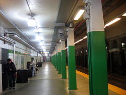
- Copley (MBTA station)
-
COPLEY
Outbound platformStation statistics Address 640 Boylston St. at 230 Dartmouth St. under Copley Square, Downtown Boston Coordinates 42°21′0.5″N 71°4′39.09″W / 42.350139°N 71.077525°WCoordinates: 42°21′0.5″N 71°4′39.09″W / 42.350139°N 71.077525°W Lines Platforms 2 side platforms Tracks 2 Other information Opened October 3, 1914 Accessible 
Owned by Massachusetts Bay Transportation Authority Traffic Passengers (1997) 3.582 million  0%
0%Services Preceding station MBTA Following station toward Boston CollegeGreen Line "B" Branchtoward Government Centertoward RiversideGreen Line "D" Branchtoward Cleveland CircleGreen Line "C" Branchtoward North Stationtoward Heath StreetGreen Line "E" Branchtoward LechmereCopley is a station on the MBTA Green Line light rail subway in Boston, Massachusetts. Located in and named after Copley Square, the station has entrances and exits along Boylston Street and Dartmouth Street.
As there is no connection between the inbound and outbound platforms, travelers must exit the station, cross the street, and pay again to switch directions at this station. Alternately, a free inbound-outbound transfer can be made by traveling one stop east to Arlington station, where the two platforms are connected by a paid mezzanine lobby.
Immediately west of Copley station, the Green Line "E" Branch splits off from the main line via a flat junction, running under Huntington Avenue towards its terminus at Heath Street. Because inbound and outbound trains must be carefully coordinated when traversing the junction, this location is one of the bottlenecks limiting peak capacity of the Green Line.[citation needed]
Attractions
Accessibility
Copley is fully wheelchair accessible, following extensive station renovation completed in 2011.
External links
- MBTA - Copley Station
 Media related to Copley (MBTA station) at Wikimedia Commons
- MBTA Projects Under Construction: Copley Station
- Dartmouth Street entrance from Google Maps Street View
 Massachusetts Bay Transportation Authority
Subway lines
(List of stations)Blue Line • Green Line ("B" Branch · "C" Branch · "D" Branch · "E" Branch) • Orange Line • Red Line (Ashmont–Mattapan High Speed Line)


Commuter
Rail lines
(List of stations)Fairmount • Fitchburg • Framingham/Worcester • Franklin • Greenbush • Haverhill • Kingston/Plymouth • Lowell • Middleborough/Lakeville • Needham • Newburyport/Rockport • Providence/StoughtonBus routes
(List of routes)Silver Line • Crosstown routes • Key routes • Trackless trolleys • Routes in East Boston, Chelsea, and Revere • Routes in Melrose, Reading, Stoneham, and Wakefield • MBTA bus routes in North Shore, Massachusetts • Routes in South BostonUnder construction South Coast RailProposed lines Former lines Other Accessibility • Arts on the Line • Boat • Boston-area streetcar lines • "Charlie on the M.T.A." • CharlieCard • History • Police • Nomenclature • Newton rail accident • The RideCurrently operating light rail and streetcar systems in the United States ArkansasArizonaCaliforniaMUNI: Cable Car, F Market & Wharves, and Metro lines · Metro Rail: Blue Line, Green Line and Gold Line · Sacramento RT · San Diego Trolley · Sprinter · Santa Clara VTA · Waterfront Red CarColoradoFloridaGeorgiaRiver Street StreetcarLouisianaMassachusettsMarylandMinnesotaMissouri / IllinoisNew JerseyNew YorkNorth CarolinaOhioOregonPennsylvaniaPittsburgh Light Rail · SEPTA Routes 15, 101, 102, and Subway–Surface LinesTennesseeTexasUtahVirginiaWashingtonWisconsin
This tram-, streetcar-, or light rail-related article is a stub. You can help Wikipedia by expanding it. This Massachusetts train station-related article is a stub. You can help Wikipedia by expanding it.

